Piedras Marcadas Canyon Hike
In Albuquerque Region
Map File Source: DeLorme
 Hike Key: H10471
Last Updated: 04/05/2021 12:00am
Last Updated By: Dawn McIntyre
Hike Class: A (Easy)
Hike Distance: 3.8 mi
Minimum Elevation: 5176 ft
Elevation Change: 120 ft
Total Uphill: 270 ft
Total Downhill: 270 ft
Avg. Grade: 4 %
Route Type: Figure8
On Trail: Yes
Paved or Gravel Roads: Yes
GPS Advised: No
Drive Distance Round Trip: 30 mi
Drive Time One-Way: 0:30
Hiking Seasons: Spring, Fall, and Winter
New Mexico Game Unit: 9
Hike Status: In Process
Highlights
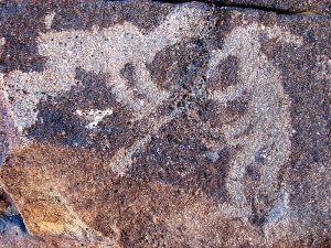
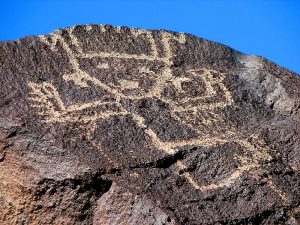
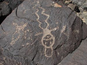
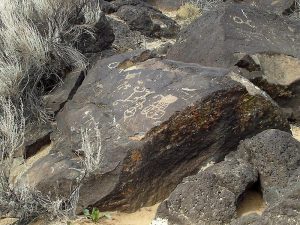
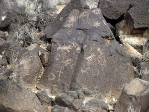
Explore several canyons at Piedras Marcadas, which has the densest concentration of images in Petroglyph National Monument.
CautionsSome steep parts; walking in sand.
Trailhead Directions
I-25 north to Paseo del Norte exit. Drive west to Golf Course and turn right (north). See brown Piedras Marcadas Canyon sign in median and turn left onto Jill Patricia. Turn right into Piedras Marcadas parking lot for Petroglyph National Monument.
Actual Hike
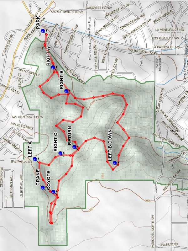
Walk up a paved path and through gates, turning left onto the trail. At RIGHT A (0.2 mi) turn and follow along the base of the volcanic escarpment. Look for numbered signs (1 through 6). Large groups of petroglyphs are behind these signs, including faces, birds, shields, starbursts, crosses, hand and footprints, katchinas, kokopelli, deer, spirals and snakes. At RIGHT B (0.55 mi) turn and continue along the base of the escarpment to RETURN (1.1 mi) and walk to the right. The official trail ends at sign 6, but this hike continues into the next canyon. At RIGHT C (1.2 mi) turn and follow the canyon wall north to LEFT A (1.4 mi), then west past CRANE (1.5 mi), where a crane seems to be feeding its baby. Farther along the west wall locate COYOTE (1.6 mi), where a real coyote watched us. Continue into the last canyon, which has construction debris, but also nice petroglyphs. At the end retrace route into large canyon and walk along south wall to RETURN (2.25 mi). Bear right on a trail that leads up onto the escarpment. Once there, follow a two-track with a view of Paseo del Norte. At LEFT B DOWN (2.6 mi) descend into the canyon along a ridge, then left again on a clear trail. Cross the fence and follow the trail around the hillside to rejoin the main trail and return to the parking area.
Comments
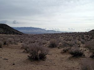
This hike is really a B because of the total vertical but, because it is such a well established trail, it has been made an A. With 5,000 images, Piedras Marcadas (marked rocks) Canyon is home to the densest concentration of petroglyphs in Petroglyph National Monument. There are more than 20,000 images in the park as a whole. Most of them were carved 400 to 700 years ago by ancestors of today’s Pueblo people. Piedras Marcadas is one of the least visited sites and a good place to see wildlife. In December 2011 we saw 15 jackrabbits, 8 cottontails, 1 coyote, 2 antelope squirrels, a hawk and a flicker.
WaypointsPARK: N35 11.327, W106 41.154
RIGHT A: N35 11.275, W106 41.356
RIGHT B: N35 11.209, W106 41.500
RETURN: N35 11.169, W106 41.841
RIGHT C: N35 11.239, W106 41.881
LEFT A: N35 11.366, W106 41.914
CRANE: N35 11.327, W106 42.089
COYOTE: N35 11.274, W106 42.116
LEFT B DOWN: N35 10.967, W106 41.938
Hike GPS File Name: PiedrasMarcadasWayTrack_WH.gpx
Hike GPS File: Click link to download hike waytrack file
Text Author: Judie Schwartz
Map Author: Marilyn Warrant
Waypoints Author: Bill Hansen
Track Author: Bill Hansen
Maintainer: Dawn McIntyre
Editor: Howard Carr