Griegos Drain North from Matthew Hike
In Albuquerque Region
Map File Source: DeLorme
 Hike Key: H10455
Last Updated: 06/29/2021 12:00am
Last Updated By: Marilyn Fixer
Hike Class: A (Easy)
Hike Distance: 4.2 mi
Minimum Elevation: 4964 ft
Elevation Change: 10 ft
Total Uphill: 10 ft
Total Downhill: 10 ft
Avg. Grade: %
Route Type: InOut
On Trail: Yes
Paved or Gravel Roads: Yes
GPS Advised: No
Drive Distance Round Trip: 35 mi
Drive Time One-Way: 0:30
Hiking Seasons:
New Mexico Game Unit: 9
Hike Status: Published
Highlights
Shady hike along an irrigation ditch.
CautionsNone.
Trailhead Directions
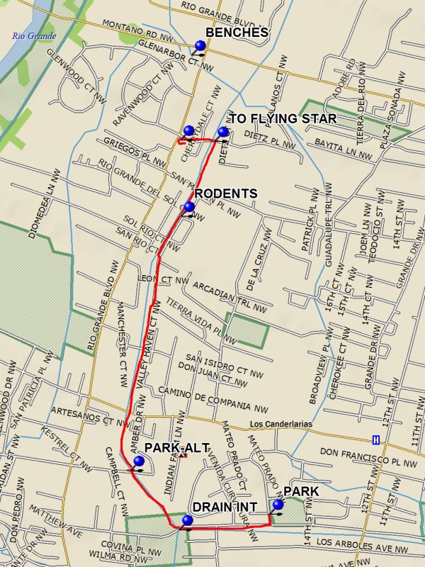
Take Candelaria west to Rio Grande. Turn south (left) on Rio Grande, then left again on Matthew. Go east on Matthew until you come to Matthew Meadows Park. PARK (0.0 mi) there.
Actual Hike
Go south from the park a few feet to the Alameda Drain, and walk along it going west. At DRAIN INT (0.4 mi), turn north (right) and follow the Griegos Drain. If you want a really short hike, there’s another parking location on Campbell (PARK-ALT (0.7 mi)). Keep to the east side of the drain to get the most shade. Near waypoint RODENTS (1.6 mi), there may be some mystery rodents swimming in the water — see if you can figure out if they’re rats, muskrats, or something else. To get to the Flying Star, a convenient place to stop for refreshments, turn left at TO FLYING STAR (1.9 mi) and take Dietz PL to Rio Grande Blvd. The FLYING STAR (2.1 mi) restaurant will be on your left. Return the way you came.
If you want a longer hike (about 5 mi total), continue going north following the Griegos Drain until just before Montano. Take a break at the BENCHES in the shade. Then return.
Comments
There are wildflowers growing along the sides of the drain. In the early morning in the summer you can see female hummingbirds catching bugs in the drain just above the water. Most of the drain walk is on packed dirt, though there is a paved bike trail option for some of the distance.
WaypointsPARK: N35 07.144, W106 39.748
DRAIN INT: N35 07.094, W106 40.091
PARK-ALT: N35 07.278, W106 40.277
RODENTS: N35 08.069, W106 40.085
TO FLYING STAR: N35 08.302, W106 39.956
FLYING STAR: N35 08.306, W106 40.086
BENCHES: N35 08.571, W106 40.043
Hike GPS File Name: GriegosDrainNorthfromMatthewWayTrackMod_MW.gpx
Hike GPS File: Click link to download hike waytrack file
Text Author: Marilyn Warrant
Map Author: Marilyn Warrant
Waypoints Author: Marilyn Warrant
Track Author: Marilyn Warrant
Maintainer: Marilyn Warrant
Editor: Howard Carr