Sandia Ski Area Outer Loop Hike
In Sandia Mountain East Region
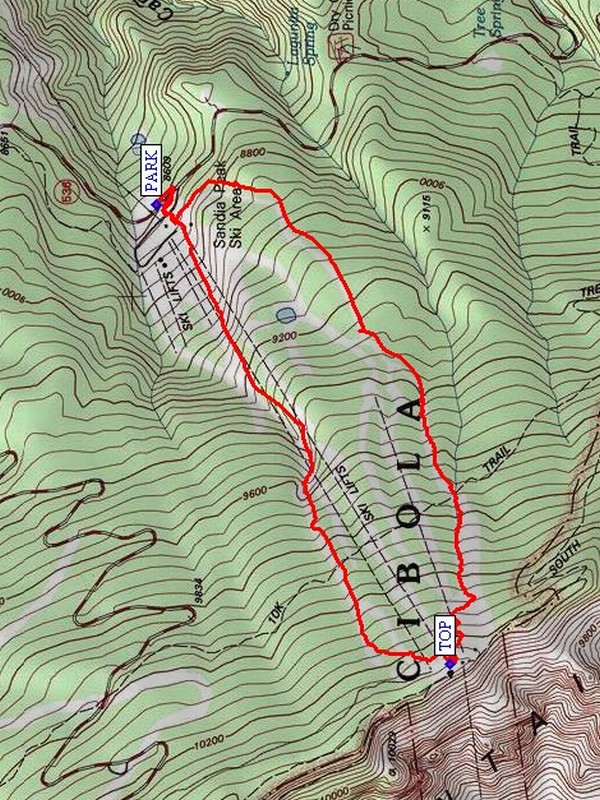
Map File Source: NG Topo
 Hike Key: H10448
Last Updated: 03/13/2021 12:00am
Last Updated By: Marilyn Fixer
Hike Class: D (Difficult)
Hike Distance: 4 mi
Minimum Elevation: 8619 ft
Elevation Change: 1669 ft
Total Uphill: 1713 ft
Total Downhill: 1713 ft
Avg. Grade: 16 %
Route Type: CW Loop
On Trail: Yes
Paved or Gravel Roads: Yes
GPS Advised: Yes
Drive Distance Round Trip: 58 mi
Drive Time One-Way: 0:45
Hiking Seasons: Spring, Summer, and Fall
New Mexico Game Unit: 8
Hike Status: Published
Highlights
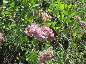
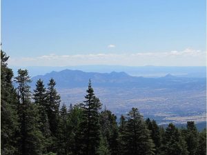
Green grass, wildflowers, views to the west as we hike along ski trails.
CautionsHiking poles recommended for the steep downhill return.
Trailhead Directions
From Albuquerque drive I-40 east to Tijeras exit 175 and stay left to NM 14 North toward Cedar Crest, then after about 6 miles on NM14, turn left onto SR536 toward Sandia Crest. After about 7 miles on SR536 you will reach the Sandia Peak Ski Area. Park your car in the wide area on the left (west) side of the highway just past the turn-in to the ski area. Do not park in the ski area parking lot; you will not want to return hours later and find your ride behind a locked gate.
Actual Hike
On the left or south side of PARK (0.0 mi), find the trail leading up thru the brush to the parking lot, cross this lot and then ascend the wooden stairs on the right (north) side of the ski lodge and buildings. Make your way across the wooden decks and stairs up to the service road at the ski lift base. This hike uses the green ski trails up the mountain on the south side (to your left) of the ski area, and the blue ski trails to the north side of the ski area on the way down. The last half-mile on the way up can seem especially steep. This hike skips most of the bike trails which crisscross the ski runs.
In June 2011 we enjoyed the wildflowers and attendant butterflies in the open grassy ski-runs all the way up and down the mountain. The grass in some areas was knee-high. If a hiker wants to pick a wildflower bouquet, remind them the Forest Service frowns on this and backs it up with a $100 fine. Remember the bicycles and safely avoid them if they come racing down the trails. When you reach the TOP (2.3 mi), there are outdoor tables and benches where you can take a break and enjoy the views all around. There are restrooms and a water fountain in the lower level of the restaurant as well as in the upper tram station. Return to the ski area base by one of the ski runs to your left, which will converge at the base and your vehicle.
Comments
This hike is all up and all down, but offers cool mountain air and great views. During dry summers, this area is usually open when the surrounding trails are closed due to fire danger. During these times, you may call the Sandia Ranger District Office at 281-3304 (8 am – 4:30 pm) to inquire/confirm that this area is open for hiking. This hike is just one of many possible ways to hike these ski-runs (see also the Sandia Ski Area hike, on which this hike description is based).
WaypointsPARK: N35 12.449, W106 24.773
TOP: N35 11.773, W106 26.061
Hike GPS File Name: SandiaSkiAreaOuterLoopWayTrack_MW.gpx
Hike GPS File: Click link to download hike waytrack file
Text Author: Marilyn Warrant
Map Author: Marilyn Warrant
Waypoints Author: Marilyn Warrant
Track Author: Marilyn Warrant
Maintainer: Not Assigned
Editor: Howard Carr