La Leña South Mesa Top Loop Hike
In Cabezon Region
Map File Source: NG Topo
 Hike Key: H10434
Last Updated: 12/15/2020 12:00am
Last Updated By: Marilyn Warrant
Hike Class: B (Moderate)
Hike Distance: 5.2 mi
Minimum Elevation: 6458 ft
Elevation Change: 158 ft
Total Uphill: 425 ft
Total Downhill: 425 ft
Avg. Grade: 4 %
Route Type: CW Loop
On Trail: No
Paved or Gravel Roads: No
GPS Advised: Yes
Drive Distance Round Trip: 150 mi
Drive Time One-Way: 1:45
Hiking Seasons: Spring and Fall
New Mexico Game Unit: 7
Hike Status: Published
Access Description: Cabezon Area Access
Highlights
Views from the mesa of the Rio Puerco Valley, Cabezon Peak, erosion features, and sandstone formations.
CautionsMost of hike off trail.
Trailhead Directions
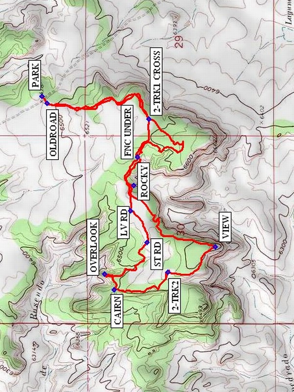
From Albuquerque take I-25 north to Bernalillo. At Bernalillo take US 550 to San Ysidro. Drive west 18 mi. past intersection of SR 4 and US 550 in San Ysidro to San Luiz Rd. Turn left and drive 12 mi. on San Luis Road (past Torreon Rd.), veer to the right at TURN1 then turn right after another 2 mi. at TURN2. Go uphill for another 4.4 mi, and PARK (0.0 mi) on or slightly off of a two-track road on the right. The road crosses an arroyo at one point, but the bottom is mostly rock.
Actual Hike
Cross the dirt road onto an OLDROAD and follow it south and then southwest past 2-TRK1 CROSS (0.7 mi). Go out on this mesa protrusion as far as you wish, or keep going west at 2-TRK1 CROSS. Go under a fence at FNC UNDER (1.4 mi) and continue west on another old road. At ROCKY (1.6 mi), go southwest until you reach the edge of the mesa, and walk along the edge until you reach a VIEW (2.3 mi) to the south. Go northwest then north to another two-track 2-TRK2 (2.7 mi), then north to a CAIRN (3.1 mi) and an OVERLOOK (3.3 mi) to the north. Go southeast to meet up with another old road at ST RD (3.7 mi), but leave it at LV RD (3.9 mi) to go east back to ROCKY. Return the rest of the way as you came, taking the shortcut back to 2-TRK1 CROSS.
Comments
Wonderful views from this mesa top.
WaypointsTURN1: N35 37.926, W107 06.500
TURN2: N35 38.135, W107 07.938
PARK: N35 41.140, W107 10.811
OLDROAD: N35 41.118, W107 10.850
2-TRK1 CROSS: N35 40.643, W107 10.937
FNC UNDER: N35 40.699, W107 11.154
ROCKY: N35 40.715, W107 11.317
VIEW: N35 40.337, W107 11.664
2-TRK2: N35 40.558, W107 11.809
CAIRN: N35 40.806, W107 11.910
OVERLOOK: N35 40.851, W107 11.818
ST RD: N35 40.653, W107 11.638
LV RD: N35 40.731, W107 11.459
Hike GPS File Name: LaLenaSouthMesaTopLoopWayTrackRev_MW.gpx
Hike GPS File: Click link to download hike waytrack file
Text Author: Marilyn Warrant
Map Author: Marilyn Warrant
Waypoints Author: Marilyn Warrant
Track Author: Marilyn Warrant
Maintainer: Marilyn Warrant
Editor: Howard Carr