Paseo de la Mesa Multi-Use Trail Hike
In Albuquerque Region
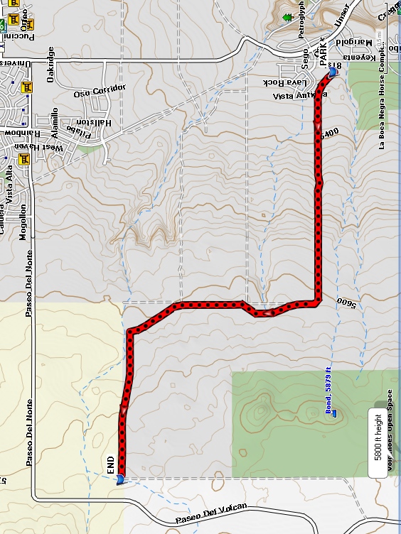
Map File Source: Garmin BaseCamp
 Hike Key: H10428
Last Updated: 06/29/2021 12:00am
Last Updated By: Marilyn Fixer
Hike Class: B (Moderate)
Hike Distance: 4.1 mi
Minimum Elevation: 5345 ft
Elevation Change: 400 ft
Total Uphill: 400 ft
Total Downhill: 13 ft
Avg. Grade: 2 %
Route Type: Oneway
On Trail: Yes
Paved or Gravel Roads: Yes
GPS Advised: No
Drive Distance Round Trip: 16 mi
Drive Time One-Way: 0:30
Hiking Seasons: Spring, Fall, and Winter
New Mexico Game Unit: 9
Hike Status: Published
Highlights
The paved bike trail passes volcanic and geologic features. It provides 360 degree views of surrounding mountain ranges.
CautionsLittle or no shade and it can be windy.
Trailhead Directions
West on I-40 to exit 154, Unser Blvd. Drive north approximately 5.5 miles. Just past the Montano Rd. intersection Unser Blvd. climbs up through the volcanic escarpment onto the west mesa. Take the first left onto Molten Rock and then turn left on 81st Street. After .4 miles turn right into the parking area for the Paseo de la Mesa Multi-Use trail.
This will be an 8.4 mile hike unless you leave a second vehicle at the destination. To do so, once up on the mesa top continue 0.4 miles staying in the left lane. Turn left at the first traffic light onto Rainbow Blvd. Stay in the left lane and proceed through the second traffic light. At the third traffic light turn left onto Paseo del Norte and continue 3.2 miles to the hike destination and parking on the left.
Actual Hike
The paved multi-use trail proceeds west on Open Space land adjacent to Petroglyph National Monument. It passes to the north of the Southern Geologic Window, a part of the park preserved so that geologists can see the layers of lava flow from the volcanoes to the west. After about 2 miles the trail turns north (an unpaved trail continues west and south to link with the volcanoes trail in the park). Continue on the paved trail, which passes to the west of the Northern Geologic Window before turning west again.
Comments
The trail passes many volcanic and geologic features. It provides 360 degree views of the Jemez, Santa Fe, Sandia, Manzano, San Mateo and Magdalena mountain ranges as well as Mount Taylor and the Ladron and Polvadera peaks. There is little or no shade and it can be windy. See the Open Space Trail Map.
WaypointsPARK: N35 09.489, W106 43.753
END: N35 10.785, W106 46.857
Hike GPS File Name: PaseoDeLaMesa.gpx
Hike GPS File: Click link to download hike waytrack file
Text Author: Judie Schwartz
Map Author: Marilyn Warrant
Waypoints Author: Bill Hansen
Track Author: Bill Hansen
Maintainer: Dawn McIntyre
Editor: Marilyn Warrant