Del Orno – N Crest – Agua Sarca Loop Hike
In Sandia Mountain East Region
Map File Source: NG Topo
 Hike Key: H10412
Last Updated: 02/25/2025 9:33pm
Last Updated By: Marilyn Fixer
Hike Class: E (Most difficult)
Hike Distance: 6.8 mi
Minimum Elevation: 6384 ft
Elevation Change: 2696 ft
Total Uphill: 2700 ft
Total Downhill: 2700 ft
Avg. Grade: 16 %
Route Type: Loop
On Trail: No
Paved or Gravel Roads: Yes
GPS Advised: Yes
Hiker Limit (NF/BLM/NP): 15 (Sandia Wilderness)
Drive Distance Round Trip: 50 mi
Drive Time One-Way: 0:45
Hiking Seasons: Spring and Fall
New Mexico Game Unit: 8
Hike Status: Published
Highlights
A challenging adventure hike over a little used route in the north Sandia Mountains.
CautionsSome portions of this hike are very steep (up to 24% grade), so wear boots with sticky soles and bring your trekking poles. Avoid scheduling during hot weather.
Trailhead Directions
I-25 north to Placitas exit (exit 242). Go east on SR 165 for 5 miles. Tunnel Springs Road (Forest Road 231) is on the right, just before mile marker 5 at LEAVE SR 165. Follow it (rough dirt road) and signs for about 1.5 miles to the Tunnel Springs trailhead. Pay fee there, continue on to the parking area, and PARK (0.0 mi). Note the springs pouring water out a pipe at south side of road just before entering parking area.
Actual Hike
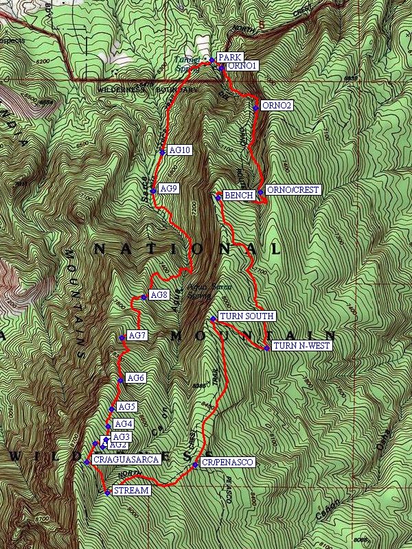
Begin hiking from the Tunnel Spring trailhead. The turnoff to the del Orno Trail is just past the wilderness boundary sign at ORNO1 (0.1 mi). Go southeast, then south at ORNO2 (0.4 mi) to the intersection with the N Crest Trail at ORNO/CREST (0.8 mi). Shortly after that, start going west to BENCH (1.2 mi), then south south-east to TURN N-WEST (2.1 mi). TURN SOUTH (2.4 mi) to the intersection with the Penasco Blanco Trail at CR/PENASCO (3.2 mi). Hike southwest to the STREAM (3.7 mi). Go northwest to the intersection of the N Crest Trail with the Agua Sarca Trail at CR/AGUASARCA (3.9 mi). From there, follow the cairns as best you can in a northerly direction. A number of waypoints are provided in case the trail is hard to follow; see AG1 (4.1 mi), AG2 (4.1 mi), AG3 (4.2 mi), AG4 (4.2 mi), AG5 (4.3 mi), and AG6 (4.5 mi). AG7 (4.7 mi) is a large pile of rocks that is a noticeable landmark. AG8 (5.1 mi) marks a distinct “T” in the trail. Continue past AG9 (6.0 mi) going north to a saddle point at AG10 (6.2 mi), then back to the parking area.
Comments
The name of the del Orno Trail should properly be the Ojo del Orno Trail. This hike description is based on the trail descriptions in Coltrin’s Sandia Mountain Hiking Guide. Some portions of this hike are very steep (up to 24% grade), so wear boots with sticky soles and bring your trekking poles.
Addendum 06/14/2016: The Ojo del Orno portion of this hike is about 0.8 miles long with an elevation change of 986 feet. It is steep and rough with loose slippery rock and is not part of the maintained USFS trail system. It is a direct route up/down the mountain and the alternative to this is a 3.3 mile broad loop of the North Crest Trail TR130 to the east.
WaypointsPARK: N 35 17.487, W 106 26.372
ORNO1: N 35 17.451, W 106 26.323
ORNO2: N 35 17.280, W 106 26.143
ORNO/CREST: N 35 16.921, W 106 26.119
BENCH: N 35 16.896, W 106 26.340
TURN N-WEST: N 35 16.256, W 106 26.086
TURN SOUTH: N 35 16.382, W 106 26.365
CR/PENASCO: N 35 15.757, W 106 26.460
STREAM: N 35 15.636, W 106 26.919
CR/AGUASARCA: N 35 15.767, W 106 27.023
AG1: N 35 15.848, W 106 26.981
AG2: N 35 15.832, W 106 26.944
AG3: N 35 15.865, W 106 26.923
AG4: N 35 15.920, W 106 26.915
AG5: N 35 15.993, W 106 26.895
AG6: N 35 16.117, W 106 26.851
AG7: N 35 16.300, W 106 26.843
AG8: N 35 16.473, W 106 26.728
AG9: N 35 16.926, W 106 26.677
AG10: N 35 17.091, W 106 26.630
Hike GPS File Name: DelOrno-NCrest-AguaSarcaLoopWayTrack_DVDV.gpx
Hike GPS File: Click link to download hike waytrack file
Text Author: Bill Davidson
Map Author: Marilyn Warrant
Waypoints Author:
Track Author:
Maintainer: Not Assigned
Editor: Marilyn Warrant