La Mesita Blanca Northeast Hike
In Tohajillee Region
Map File Source: DeLorme
 Hike Key: H10337
Last Updated: 12/15/2020 12:00am
Last Updated By: Marilyn Warrant
Hike Class: C (Challenging)
Hike Distance: 6.6 mi
Minimum Elevation: 5815 ft
Elevation Change: 290 ft
Total Uphill: 610 ft
Total Downhill: 610 ft
Avg. Grade: 5 %
Route Type: Loop
On Trail: No
Paved or Gravel Roads: No
GPS Advised: Yes
Drive Distance Round Trip: 100 mi
Drive Time One-Way: 1:15
Hiking Seasons: Spring, Fall, and Winter
New Mexico Game Unit: 9
Hike Status: Published
Highlights
Hike to an area containing beehive and sandstone formations.
CautionsMost of this hike is off trail.
Trailhead Directions
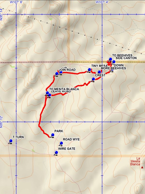
From Albuquerque take I-40 West to the Tohajillee exit. Go north for 5 miles to the village. Just before the school area, turn right over a CATTLE GUARD with yellow sides (7.8 mi from the I-40 interchange). Then an immediate left. Drive for about 8 miles, taking the obvious main road at any turns. At T TURN go a sharp right and proceed for 1.0 miles to a FENCE GATE on the left. Go through the fence gate and drive the two track, turning left at the ROAD WYE and go to the windmill and PARK (0.0 mi).
Actual Hike
Start the hike by continuing on the two track which goes up on a ridge which forms the east side of the La Mesita Blanca beehive and other formations. Proceed along the ridge northward to a point where you LEAVE ROAD (1.0 mi) near the head of the canyon to your left. Turn northeast heading toward the CREST (2.2 mi) in the distance, a broad dam-like formation. Find your way up the right side of the formation and after crossing a two track go down into a small broad canyon, staying near its right wall. The canyon will deepen and reach a point where there is a drop-off. Go along the left side for about 200 feet and find a way DOWN (2.7 mi) into the bottom of the canyon. It will then be about 0.3 miles to the mouth of the SIDE CANYON (2.9 mi). Venture into the side canyon to the first wall. It would be risky to continue beyond this point to a second wall, which is not scalable without rope and grappling hook. You will be able to observe this wonder later from above. Return and at the mouth of the canyon go left and up a steep loose trail to the ledge above. Go along the base of the mesa, circling around and going to the west where there will be a way up top TO BEEHIVES (3.1 mi). Wander around the area observing the interesting formations. Then head back southwest toward the canyon you came down where there will be MORE BEEHIVES (3.8 mi). Go northwest among these formations until the two track is reached. Cross the road and go toward the TINY MESA (4.1 mi) , then cross the broad and boring terrain, going due west to a box canyon on the right. Pass around the deep arroyo at the canyon head and go to a notch where it is possible to get UP (4.9 mi) and onto the ridge. Continue west for a short distance and JOIN ROAD (5.0 mi). Go left down the two track to the head of the La Mesita Blanca area canyon. Here there is the option of going TO MESITA BLANCA to explore that area before returning to the ridge and returning to parking.
Comments
The rating is C because segments of the hike are off trail and sometimes difficult.
WaypointsCATTLE GUARD: N 35 05.820, W 107 06.662
ROAD WYE: N 35 11.557, W 107 05.053
T TURN: N 35 11.600, W 107 06.230
TO MESITA BLANCA: N 35 12.492, W 107 05.380
WIRE GATE: N 35 11.386, W 107 05.171
PARK: N 35 11.712, W 107 05.254
LEAVE ROAD: N 35 12.455, W 107 05.330
CREST: N 35 12.751, W 107 04.310
DOWN: N 35 12.936, W 107 03.869
SIDE CANYON: N 35 13.072, W 107 03.833
TO BEEHIVES: N 35 13.120, W 107 03.911
MORE BEEHIVES: N 35 12.882, W 107 04.173
TINY MESA: N 35 12.926, W 107 04.400
UP: N 35 12.883, W 107 05.065
JOIN ROAD: N 35 12.853, W 107 05.160
Hike GPS File Name: LaMesitaBlancaNortheastWayTrack_DBDB.gpx
Hike GPS File: Click link to download hike waytrack file
Text Author: Dick Brown
Map Author: Dick Brown
Waypoints Author: Dick Brown
Track Author: Dick Brown
Maintainer: Not Assigned
Editor: Howard Carr