Cerro Pelado Hike
In Jemez Mountains Region
Map File Source: DeLorme
 Hike Key: H10333
Last Updated: 11/23/2021 12:00am
Last Updated By: Marilyn Fixer
Hike Class: E (Most difficult)
Hike Distance: 10.1 mi
Minimum Elevation: 8450 ft
Elevation Change: 1650 ft
Total Uphill: 2355 ft
Total Downhill: 2355 ft
Avg. Grade: 12 %
Route Type: InOut
On Trail: Yes
Paved or Gravel Roads: Yes
GPS Advised: Yes
Drive Distance Round Trip: 150 mi
Drive Time One-Way: 1:30
Hiking Seasons: Spring, Summer, and Fall
New Mexico Game Unit: 6A
Hike Status: Inactive
Highlights
Hike to Cerro Pelado watchtower.
CautionsNone.
Trailhead Directions
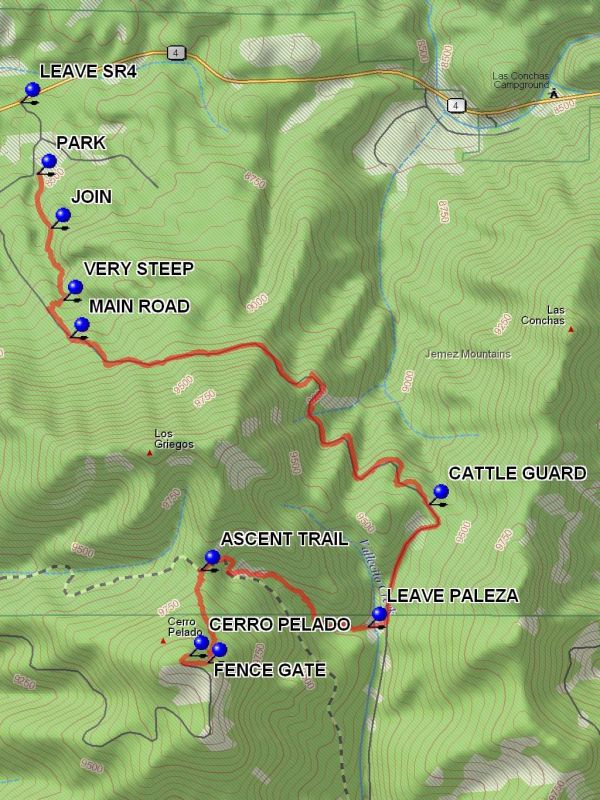
From Albuquerque take I-25 N to exit 242, Go west on US 550 to San Ysidro. Go right (north) on SR 4 to La Cueva. Continue on SR 4 for 10 miles east to [LEAVE SR4]. Turn right onto the dirt road. Drive for 0.4 miles to U bend in the road and PARK (0.0 mi) at 0.0 miles.
Actual Hike
Take the washed out “road” to a JOIN (0.2 mi). Continue right on the road until the road dead ends at wall that is VERY STEEP (0.5 mi). Go up this wall and onto another road going uphill. This road will connect to the MAIN ROAD (0.8 mi). Go left and follow this road, which will have views of the Caldera to the north, to the CATTLE GUARD (2.9 mi). This point is common to the Peralta-Paliza Loop hike. Go through the fence and start down Paliza Canyon, stay on the road until you are almost to the small lake and cross the valley where you will LEAVE PALEZA (3.6 mi), going up a side canyon to the ASCENT TRAIL (4.4 mi). Go left up this trail to a FENCE GATE (4.9 mi). Go through the gate and on to CERRO PELADO (5.0 mi), where there will be a fire tower and some views. During fire season the tower will be manned and you can go up the stairs to chat with the person on duty. Enjoy the 360 degree views then return the way you came to parking.
Comments
Access to the trailhead for this hike has been closed (gated) as a result of the Los Conchas fire. Whether this closure is temporary of permanent is not known. The quality of this hike has been severely degraded as a result of that fire.
WaypointsLEAVE SR4: N35 48.855, W106 33.622
PARK: N35 48.623, W106 33.556
JOIN: N35 48.448, W106 33.500
VERY STEEP: N35 48.213, W106 33.452
MAIN ROAD: N35 48.093, W106 33.425
CATTLE GUARD: N35 47.551, W106 31.989
LEAVE PALEZA: N35 47.153, W106 32.234
ASCENT TRAIL: N35 47.338, W106 32.902
FENCE GATE: N35 47.038, W106 32.874
CERRO PELADO: N35 47.061, W106 32.948
Hike GPS File Name: CerroPeladoWayTrack_DBDB.gpx
Hike GPS File: Click link to download hike waytrack file
Text Author: Dick Brown
Map Author: Marilyn Warrant
Waypoints Author: Dick Brown
Track Author: Dick Brown
Maintainer: Not Assigned
Editor: Howard Carr