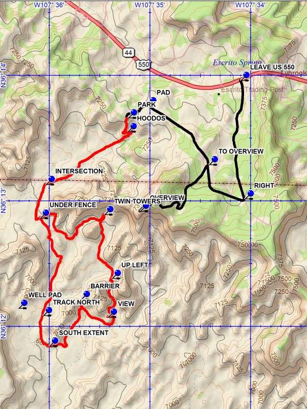
Lybrook Badlands West Hike
In Cuba Region
Map File Source: DeLorme
 Hike Key: H10327
Last Updated: 12/15/2020 12:00am
Last Updated By: Marilyn Warrant
Hike Class: C (Challenging)
Hike Distance: 7.9 mi
Minimum Elevation: 6870 ft
Elevation Change: 390 ft
Total Uphill: 450 ft
Total Downhill: 450 ft
Avg. Grade: 3 %
Route Type: Loop
On Trail:
Paved or Gravel Roads:
GPS Advised:
Drive Distance Round Trip: 240 mi
Drive Time One-Way: 2:15
Hiking Seasons: Spring and Fall
New Mexico Game Unit: 7
Hike Status: Inactive
Cautions
None.
Trailhead Directions
From Albuquerque take I-25 north to Bernalillo. Go west on US 550 through San Ysidro, thru Cuba (reset the odometer here), Thru Counselors, and past the small refinery on the right side of the road. Shortly after cresting the rise and just before a yellow crossing sign on the right, LEAVE US 550 on the left. This turn will be about 37 miles from Cuba. Take the dirt road for 1 mile and turn RIGHT at the Y where you will see a green tank down the road to the right. Go 0.7 miles to an intersection with the road TO OVERVIEW. If you go to the overview it will be 1 mile to the OVERVIEW. Otherwise continue another 0.4 miles to a PAD. Turn Left and drive through the pad to a two track and go 0.2 miles to PARK (0.0 mi) on the left.
Actual Hike
From parking continue on the road for a short distance to a scenic area with interesting formations and a drop off. The road becomes impassable to vehicles as it descends. In this area there are a number of HOODOS (0.1 mi) along the way. At the bottom the road turns back, heading across open terrain, passing formations on both sides. When the “road” reaches the INTERSECTION (1.2 mi) take the fainter trail to the left. As you approach the fence bear left and go UNDER FENCE (1.6 mi) in the wash. Follow the wash and keep near the base of the large formations until you reach a low dark badlands barrier which you must go up and over. Once over bear to the left to the TWIN TOWERS (2.5 mi). Then turn back to the south and go to the narrowing terrain, entering a south going wash. Go UP LEFT (3.2 mi) a steep incline as you must pass over a “dam” in the wash. Beyond this point the terrain opens up, with mesas on east and west sides. Stay to your right and follow the low ridge up to the VIEW (3.7 mi). Then return and circle around the south end of the formation and head west. Keep along the base of the formations toward the BARRIER (4.3 mi). The are numerous interesting formations in the alcove. Then turn back and go southwest along the formations in a broadening wash until the SOUTH EXTENT (4.9 mi) is reached. There will be a faint two track taking you to a well pad road going north. At TRACK NORTH (5.3 mi) leave the well pad road and take the two track. Continue on the two track, which disappears at times, to the point where you will pass back UNDER FENCE. From this point retrace your path to parking.
Comments
This hike is changed to inactive until a way around newly posted private property has been found.
Going to the Overlook is recommended as you will be able to visit only a fraction of the large Lybrook Badlands area during the hike. This hike is “off trail” with some difficult sections. Consider this and read the descriptive material before deciding to do this hike.
WaypointsLEAVE US 550: N 36 13.963, W 107 34.141
OVERVIEW: N 36 12.920, W 107 35.138
PAD: N 36 13.761, W 107 35.067
RIGHT: N 36 13.018, W 107 34.099
TO OVERVIEW: N 36 13.290, W 107 34.456
WELL PAD: N 36 12.147, W 107 36.346
PARK: N 36 13.663, W 107 35.258
HOODOS: N 36 13.554, W 107 35.262
INTERSECTION: N 36 13.133, W 107 36.075
UNDER FENCE: N 36 12.864, W 107 36.133
TWIN TOWERS: N 36 12.893, W 107 35.494
UP LEFT: N 36 12.384, W 107 35.419
VIEW: N 36 12.077, W 107 35.457
BARRIER: N 36 12.216, W 107 35.728
SOUTH EXTENT: N 36 11.845, W 107 36.041
TRACK NORTH: N 36 12.089, W 107 36.104
Hike GPS File Name: LybrookBadlandsWestWayTrack_DBDB.gpx
Hike GPS File: Click link to download hike waytrack file
Text Author: Dick Brown
Map Author: Dick Brown
Waypoints Author: Dick Brown
Track Author: Dick Brown
Maintainer: Not Assigned
Editor: Marilyn Warrant