La Ventana Mesa Hike
In Cabezon Region
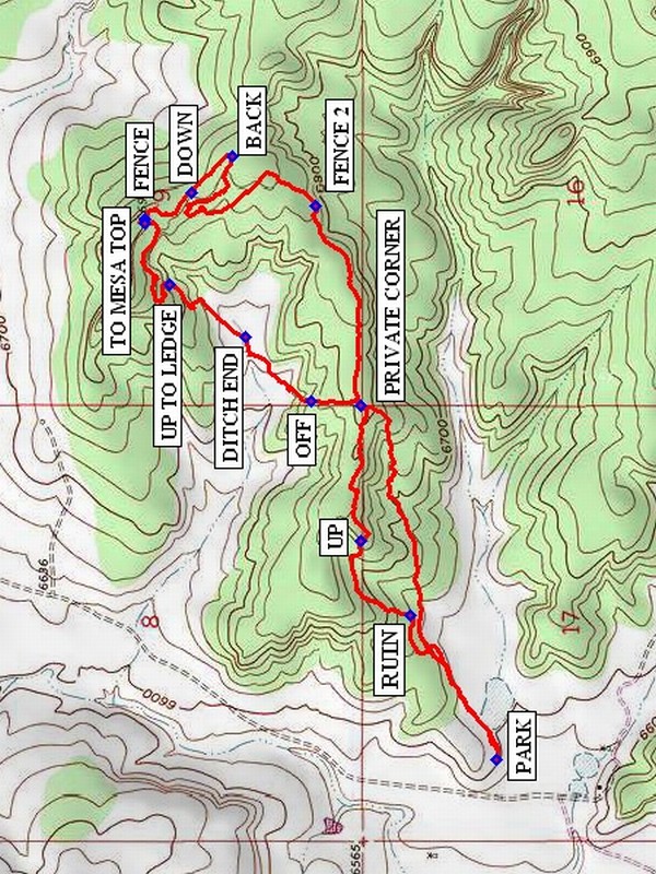
Map File Source: NG Topo
 Hike Key: H10263
Last Updated: 12/15/2020 12:00am
Last Updated By: Marilyn Warrant
Hike Class: B (Moderate)
Hike Distance: 4.5 mi
Minimum Elevation: 6600 ft
Elevation Change: 300 ft
Total Uphill: 450 ft
Total Downhill: 450 ft
Avg. Grade: 5 %
Route Type: CW Loop
On Trail: No
Paved or Gravel Roads: No
GPS Advised: Yes
Drive Distance Round Trip: 170 mi
Drive Time One-Way: 1:45
Hiking Seasons: Spring, Fall, and Winter
New Mexico Game Unit: 7
Hike Status: Published
Access Description: Cabezon Area Access
Highlights
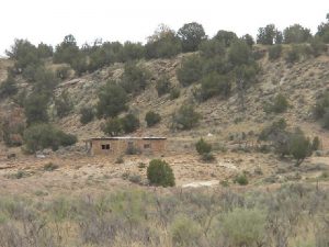
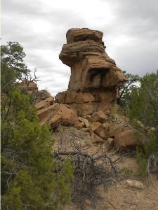
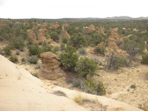
Pueblo ruins, sandstone features, views of surrounding areas.
CautionsBring hiking poles for the steep sections.
Trailhead Directions
From Albuquerque take I-25 north to Bernalillo. Take US 550 to San Ysidro. Drive west 18 mi. past intersection of SR 4 and US 550 to San Luiz Rd. Turn left and drive 8.5 miles to Torreon Rd. on the right. Turn right onto [TORREON RD] and drive 3.6 miles to a cattle guard. There the paved road turns into a dirt road. Continue 0.1 mile on the dirt road, TURN RIGHT at the intersection and continue 8.3 miles on this dirt road (the road to Deadman Peak in the Cabezon Area Access Description) to a two track on the right. Take this track for about 200 ft to beyond a low hill on the left and PARK (0.0 mi).
Actual Hike
From parking go east along the base of the ridge to the north where there will be a RUIN (0.4 mi). Continue into the canyon in the ridge and UP (0.7 mi) onto the ridge. Go along the ridge to the PRIVATE CORNER (1.1 mi) and then turn northeast. Get off the ridge at OFF (1.2 mi). Across the valley below there will be a small mesa. Head toward the mesa. After crossing the small valley floor enter an area with many interesting formations. At UP TO LEDGE (1.7 mi) turn northwest and find a path up to a ledge at the bottom of the low mesa. Turn east and follow the ledge. There will be a profusion of small dark plugs on the floor below the ledge to the east. When the east end of the small mesa is reached go to the TO MESA TOP (2.1 mi) point and find a notch taking you to the top of the mesa. Once there, you will have good views of the area. Search for the ruin on this mesa. Then go back off the east end of the mesa and walk the rocky expanse, negotiate the FENCE (2.1 mi) and go along the ledge to the DOWN (2.3 mi) point and go off the ledge. Go along the ridge, on which there will be several interesting formations. To the east you can see the edge of this large mesa area. But it is a long trek to the edge, so turn back and take the east going ridge to the private corner and off the ridge, returning to parking.
Comments
Please leave any shards where you found them.
WaypointsPARK: N 35 47.644, W 107 04.452
RUIN: N 35 47.817, W 107 04.094
UP: N 35 47.918, W 107 03.910
PRIVATE CORNER: N 35 47.916, W 107 03.575
OFF: N 35 48.018, W 107 03.566
DITCH END: N 35 48.150, W 107 03.408
UP TO LEDGE: N 35 48.301, W 107 03.278
FENCE: N 35 48.351, W 107 03.115
TO MESA TOP: N 35 48.352, W 107 03.125
DOWN: N 35 48.258, W 107 03.052
BACK: N 35 48.175, W 107 02.960
FENCE 2: N 35 48.008, W 107 03.082
Hike GPS File Name: LaVentanaMesaWayTrackAdd_DBDB.gpx
Hike GPS File: Click link to download hike waytrack file
Text Author: Dick Brown
Map Author: Marilyn Warrant
Waypoints Author: Dick Brown
Track Author: Dick Brown
Maintainer: Bill Gloyd
Editor: Marilyn Warrant