Pino Spring Short Loop Hike
In Tohajillee Region
Map File Source: NG Topo
 Hike Key: H10240
Last Updated: 01/26/2023 2:33pm
Last Updated By: Marilyn Warrant
Hike Class: C (Challenging)
Hike Distance: 4.9 mi
Minimum Elevation: 6074 ft
Elevation Change: 298 ft
Total Uphill: 320 ft
Total Downhill: 320 ft
Avg. Grade: 5 %
Route Type: Lollypop
On Trail: No
Paved or Gravel Roads: No
GPS Advised: Yes
Drive Distance Round Trip: 100 mi
Drive Time One-Way: 1:30
Hiking Seasons: Spring, Fall, and Winter
New Mexico Game Unit: 9
Hike Status: Inactive
Highlights
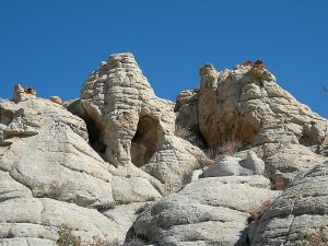
Beehive formations, red rock. Outstanding views up the Rio Puerco Valley.
CautionsCan be windy. Wear sturdy hiking boots to fend off the “ground cover” cactus. Some walking on rocks. Bring hiking poles for the steep sections.
Trailhead Directions
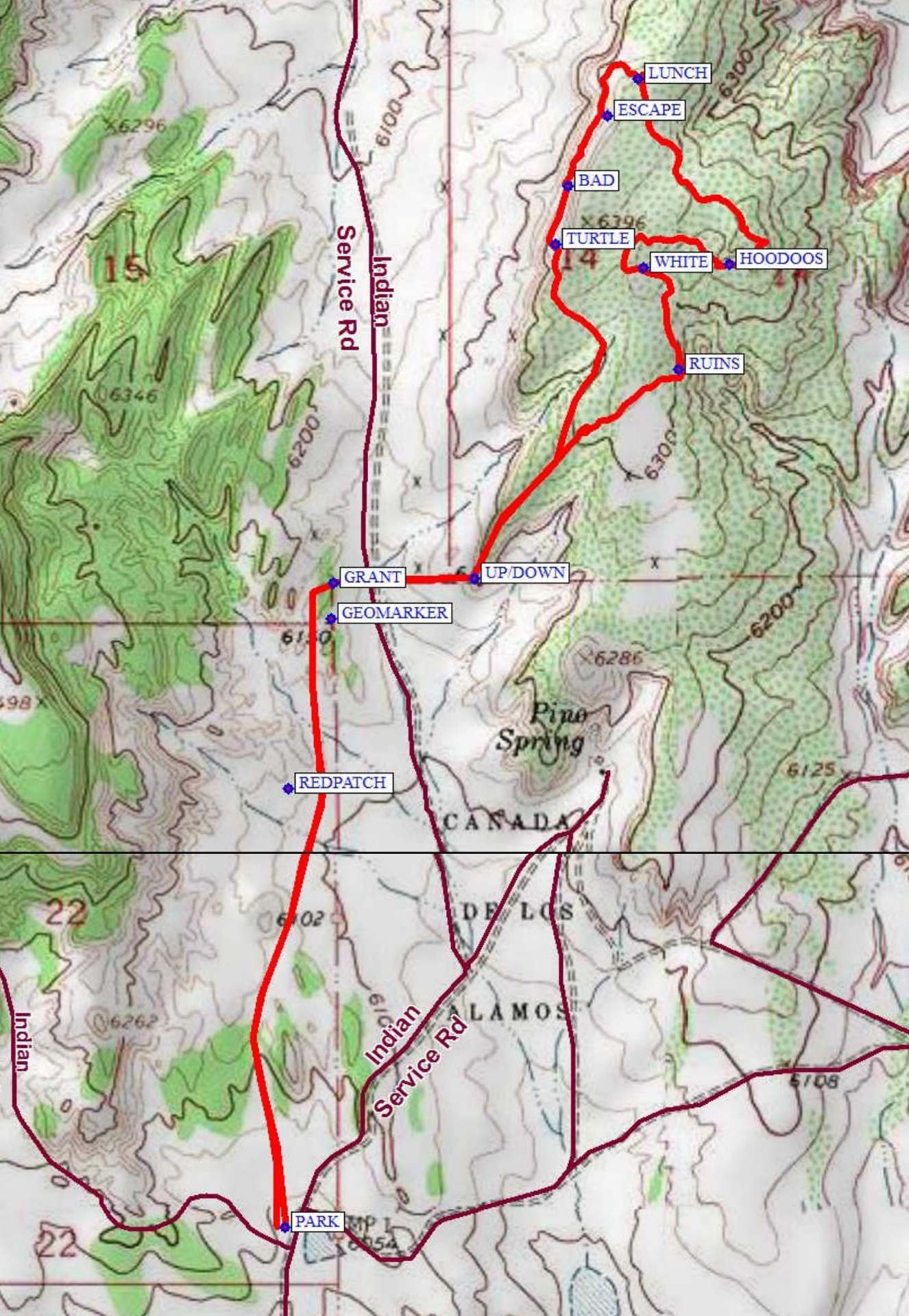
From Albuquerque take I-40 West to the Tohajillee exit. Go north approx. 5 mi. to the village. Just before school area, turn right over a cattle guard with yellow sides. Then an immediate left. Drive for approx. 8 mi., taking the obvious main road at any turns. At “T” with another main road, go left for about 4.5 mi. and look for a TURN on the right. After going through the arroyo, proceed to the east over primitive road to a “Y” in the road, take the left hand route, pull over to the left within a block of the “Y” and PARK (0.0 mi).
Actual Hike
From parking go slightly northwest then due north staying to the left of low hills, then northeast to the right of the higher mesa, heading towards the REDPATCH (0.7 mi). Going right of the Red Patch, continue nearly north up a small valley. After crossing a low spot in the hill to the right, maintaining a northward direction, stay on the left side of a large valley going past a GEOMARKER (0.9 mi) until you make a 90 deg turn at GRANT (1.0 mi), which marks the boundary of the Canada de los Alamos land grant. Go due east to UP/DOWN (1.2 mi) to get onto the mesa. Find some RUINS (1.75 mi) on the east face of the mesa then head north to the WHITE (1.95 mi) rocks then east to some HOODOOS (2.2 mi) and up a sandy slope to a good view. Go over the top of the rise to the north along part of an old road to the northwest. When the road turns west, go northwest up over the low ridge to the pines and have LUNCH (2.7 mi) with a great view to the north and west of several volcanic necks, including Cabezon. After lunch, go down onto the lower shelf of the mesa and continue around a hairpin turn heading back south. There are some “tight” points along this route beyond the ESCAPE (2.8 mi) point, and these can be avoided by going up top at the escape point. This will, however, miss some interesting terrain. If you do not use the ESCAPE point, be sure to go around the leftmost bush at BAD (3.0 mi). Just as you leave the hoodoo area, look back at the TURTLE (3.1 mi). As you go south, you’ll come across some interesting rock features. At the south end of the cliff, complete the loop and rejoin the trail from the parking area.
Comments
Either check out the road ahead of time or be prepared to turn around and hike somewhere else if the road is bad. This hike has been rerouted to avoid private land. Avoid doing this hike during inclement weather. The roads to the hike trailhead deteriorate during wet conditions. The area is very exposed. Dress warmly if doing the hike in early spring or late fall. Junipers and a few larger trees provide some shade. Wear sturdy hiking boots — as one hiker remarked “The cactus is like ground cover up there”. You may come across moss agate up on the mesa, jackrabbits, and snakes. This hike is given a “C” rating because of the uneven footing.
Hike data were determined using a Garmin GPSMap 60CSx and National Geographic TOPO v.4.6 DEM for New Mexico.
Set inactive because of bad access road.
WaypointsAccess
TURN: N35 14.737, W107 08.721
Hike
PARK: N35 15.038, W107 08.117
REDPATCH: N35 15.556, W107 08.155
GEOMARKER: N35 15.779, W107 08.087
GRANT: N35 15.825, W107 08.082
UP/DOWN: N35 15.832 W107 07.860
RUINS: N35 16.106, W107 07.536
WHITE: N35 16.239, W107 07.591
HOODOOS: N35 16.241, W107 07.430
LUNCH: N35 16.488, W107 07.601
ESCAPE: N35 16.438, W107 07.648
BAD: N35 16.346, W107 07.711
TURTLE: N35 16.270, W107 07.730
Hike GPS File Name: PinoSpringShortLoopWayTrackRev_MW.gpx
Hike GPS File: Click link to download hike waytrack file
Additional File 1 Link Click link to download an additional file.
Text Author: Theodore (Ted) Cooley
Map Author: Marilyn Warrant
Waypoints Author: Marilyn Warrant
Track Author: Marilyn Warrant
Maintainer: Marilyn Warrant
Editor: Howard Carr