Mesita De Ricardo – Northwest Passage Hike
In Ojito Region
Map File Source: Garmin BaseCamp
 Hike Key: H10235
Last Updated: 08/07/2023 10:01am
Last Updated By: Marilyn Warrant
Hike Class: C (Challenging)
Hike Distance: 6.4 mi
Minimum Elevation: 5915 ft
Elevation Change: 355 ft
Total Uphill: 1016 ft
Total Downhill: 1016 ft
Avg. Grade: 7 %
Route Type: Loop
On Trail: No
Paved or Gravel Roads: No
GPS Advised: Yes
Drive Distance Round Trip: 100 mi
Drive Time One-Way: 1:30
Hiking Seasons: Spring, Fall, and Winter
New Mexico Game Unit: 9
Hike Status: In Process
Access Description: Ojito Wilderness Area Access
Highlights
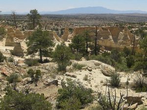
Extensive badlands, hoodoos, impressive rock formations, spectacular views.
CautionsSome steep pitches and tricky spots.
Trailhead Directions
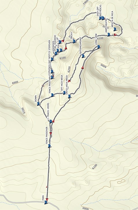
From Albuquerque take I-25 north to Bernalillo. From the intersection of I-25 and US 550 (formerly SR 44) in Bernalillo go northwest on US 550 for 20.9 miles to Cabezon Road (about 2 mi. before San Ysidro). Turn left onto Cabezon Road then go left almost immediately at the Y in the road. At 12.5 miles, turn right onto Pipeline road, and go 3.8 miles to a two track on your right. Go right and go about 0.4 miles and PARK (0.0 mi) at the fence gate.
Actual Hike
Take the pass-through to the left of the gate. Turn right and follow the north side of the fence which heads east. Find a FENCE-PASSOVER (0.4 mi) taking you to the south side of the fence. Continue along the fence, picking up a two track. The 2-TRACK-VEERS (0.7 mi) to the southeast toward the low mesa. The track goes ONTO-HIGH-MESA (1.0 mi). Once on the mesa go to the right and travel along the mesa edge to enjoy the views from the highest point in Ojito. Reach the end of the mesa for the LONG VIEW (1.6 mi) of the whole of Ojito. Turn back to the north and go along the eastern edge of the mesa where there are views of the Jemez. Go OFF HIGH MESA (2.2 mi) and go thru fence at the FENCE PASSTHRU (2.4 mi) , then go to the DOWN (2.5 mi) point. At the down point find an animal trail on the right side of the notch which takes a traverse to the base of the mesa. Go south east along the base of the mesa toward FENCE STEPOVER (3.0 mi) and enter the HOODOOS (3.1 mi) area, exploring it. Optional lunch spot. Then hug the base of the mesa on a trail to the TRICKY (3.3 mi) point where a small drop off must be negotiated. Stop at AMPHITHEATER (3.7 mi). Continue southward along the base to the east side of MESITA DE RICARDO where there is a wonderland of rock formations. Work around the south end of the mesita, then turn back north to the RED ROCKS (4.2 mi), which is another good place for lunch. Near here is CACHE (4.2 mi), a geocache, if you can find it. At the EASY OFF (4.2 mi) point (well, sort of easy) drop down off of the ledge and down into an extensive badlands area. Go upward in the canyon, traversing numerous badlands formations. The canyon will narrow as it reaches a point where the climb is UP (4.7 mi) out of the canyon into the hoodoos area. Take the route previously traveled (more or less) until the top of the high mesa is reached. Then head southwest to the fence and follow the north side of the fence to parking.
Comments
If the duration of the hike may be a concern (e.g., shorter days in the winter), it is recommended to consider hiking the (eastern) “hoodoo loop” of the hike first and on the way back determine if there is time to hike the (western) “top of the mesa loop”, before heading back to the vehicle.
In other words, upon arriving at “2-TRACK VEERS” head more northerly to the waypoint, “DOWN”. Hike down to the” HOODOOS” waypoint and on around the eastern loop, as described. Then when coming back up (about 2 hours later), consider whether time will permit to hike the western loop on top of the mesa (head for “FENCE PASSTHRU”) or whether the leader would prefer to head directly back to the vehicle (head for “2-TRACK VEERS”).
This hike contains steep pitches and some tricky spots.
WaypointsMESETA DE RICARDO: N35 31.586, W106 56.490
OJITO HIGH POINT: N35 31.827, W106 56.744
TURN: N35 31.935, W106 58.487
PARK: N35 32.112, W106 58.124
FENCE-PASSOVER: N35 32.090, W106 57.665
2-TRACK-VEERS: N35 32.073, W106 57.361
ONTO-HIGH-MESA: N35 31.932, W106 57.124
LONG VIEW: N35 31.709, W106 56.657
OFF HIGH MESA: N35 31.969, W106 57.090
FENCE PASSTHRU: N35 32.061, W106 57.112
DOWN: N35 32.168, W106 57.194
MICA: N35 32.064, W106 56.945
UNDER FENCE: N35 32.073, W106 56.768
HOODOOS: N35 32.034, W106 56.719
TRICKY: N35 31.995, W106 56.689
PINE SHADE: N35 31.934, W106 56.621
EASY OFF: N35 31.696, W106 56.375
RED ROCKS: N35 31.683, W106 56.381
UP: N35 31.985, W106 56.590
Hike GPS File Name: MesitaDeRicardoNW_DMDM.gpx
Hike GPS File: Click link to download hike waytrack file
Text Author: Dick Brown
Map Author: Dick Brown
Waypoints Author: Dick Brown
Track Author: Dick Brown
Maintainer: Dawn McIntyre
Editor: Marilyn Warrant