La Luz Spur – Kiwanis Cabin Loop Hike
In Sandia Mountain East Region
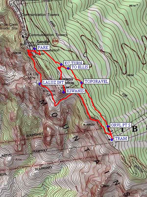
Map File Source: NG Topo
 Hike Key: H10205
Last Updated: 12/15/2020 12:00am
Last Updated By: Marilyn Warrant
Hike Class: C (Challenging)
Hike Distance: 4.3 mi
Minimum Elevation: 10110 ft
Elevation Change: 520 ft
Total Uphill: 805 ft
Total Downhill: 805 ft
Avg. Grade: 9 %
Route Type: Loop
On Trail: Yes
Paved or Gravel Roads: Yes
GPS Advised: No
Drive Distance Round Trip: 70 mi
Drive Time One-Way: 1:15
Hiking Seasons: Summer and Fall
New Mexico Game Unit: 8
Hike Status: Published
Highlights
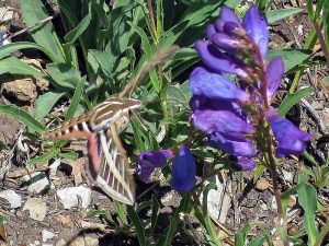
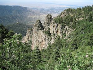
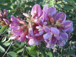
A delightful, mostly shaded summer hike with spectacular views, wildflowers and possibly some wildlife.
CautionsSome portions with narrow trail and steep dropoffs. Hiking poles recommended.
Trailhead Directions
I-40 east to Tijeras exit, North on NM 14, west on Crest Road 536 all the way to the Crest parking lot and PARK (0.0 mi). The trailhead for Crest Spur Trail 84 is at the junction of the steps coming down (south) from the Crest House and the steps going up (west) from the south end of the parking lot.
Actual Hike
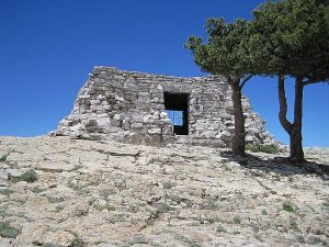
Follow trail down (west) using switchbacks and a concrete stairs 1/2 mile to juncture with main La Luz Trail at LALUZ INT (0.7 mi). Continue on around to the TRAM (2.0 mi) station, where there are public rest rooms. Don’t eat your lunch there, though. Continue on to the Kiwanis Cabin via the Crest Trail, or, as we did in July 2010 when the Crest Trail was being repaired, using the Gravel Pit Trail. You’ll go by the gravel pit itself (GRVL PT S (2.2 mi)), the top of the Gravel Pit Trail (TOPGRAVEL (2.8 mi)), and the intersection with the Ellis Trail (TO ELLIS (3.0 mi)). Take the short trail at (KC TURN (3.1 mi)) steeply up to the KIWANIS (3.5 mi) Cabin and have lunch there. Return to parking using the Buried Cable Trail. The “Relief Route” option keeps you in the shade most of the way back from the Tram.
Comments
There are steep rocky sections on this trail, with steep dropoffs to one side. Not for anyone with vertigo. But it’s one of the greatest short hikes with stupendous rock spires overlooking the city. It can be quite cool even in the hottest months because of the height and you start on the west side of the mountain that is in shade in the early morning. The flowers in early summer are stupendous, and growing in rock ledges so that they’re just the right height for photographing. Kiwanis Cabin was built out of stone in 1936 by the CCC (Civilian Conservation Corps). It looks rather like a Greek Temple perched atop the point of the cliff. Look for it behind you as you ascend the trail to the Tram Terminal.
The Sandia Ranger District has set a 25-hiker limit for this area.
WaypointsPARK: N 35 12.589, W 106 26.910
LALUZ INT: N 35 12.275, W 106 26.852
TRAM: N 35 11.771, W 106 26.062
GRVL PT S: N 35 11.890, W 106 26.106
TOPGRAVEL: N 35 12.284, W 106 26.394
TO ELLIS: N 35 12.412, W 106 26.543
KC TURN: N 35 12.448, W 106 26.616
KIWANIS: N 35 12.200, W 106 26.593
Hike GPS File Name: LaLuzSpur-KiwanisCabinLoopWayTrack_KSKS.gpx
Hike GPS File: Click link to download hike waytrack file
Text Author: Roger Holloway
Map Author: Marilyn Warrant
Waypoints Author: Ken Smith
Track Author: Ken Smith
Maintainer: Marilyn Warrant
Editor: Howard Carr