Winsor Trail to Puerto Nambe Hike
In Sangre De Cristos Region
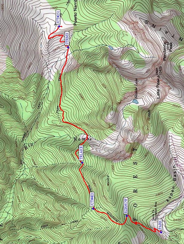
Map File Source: NG Topo
 Hike Key: H10204
Last Updated: 12/15/2020 12:00am
Last Updated By: Marilyn Warrant
Hike Class: D (Difficult)
Hike Distance: 8.7 mi
Minimum Elevation: 10260 ft
Elevation Change: 678 ft
Total Uphill: 1732 ft
Total Downhill: 1732 ft
Avg. Grade: 10 %
Route Type: InOut
On Trail: Yes
Paved or Gravel Roads: Yes
GPS Advised: No
Hiker Limit (NF/BLM/NP): 15 (Pecos Wilderness)
Drive Distance Round Trip: 160 mi
Drive Time One-Way: 1:45
Hiking Seasons: Summer and Fall
New Mexico Game Unit: 44
Hike Status: Published
Highlights
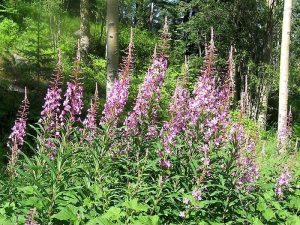
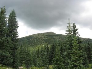
A strenuous hike through lush forest. Wildflowers; views of surrounding mountain peaks.
CautionsA rocky trail with steep sections and little soft footing. Trekking poles recommended. High altitude; not recommended for hikers with respiratory disorders.
Trailhead Directions
Take I-25 north to Santa Fe. Take the Old Pecos Trail exit 284 and follow to Paseo de Peralta. Turn right and follow to Washington Avenue, just before the pink Masonic Temple. Turn north on Washington, then east on Artist Road, which becomes Hyde Park Rd and leads to the ski area in 17 mi. The trail begins at the northwest corner of the lower parking area (PARK (0.0 mi)).
Actual Hike
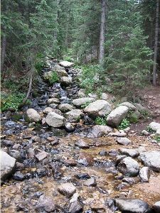
The hike follows Winsor Trail (#254), a wide, rocky, worn, popular trail, and begins at 10,250′ elevation. There is an initial 600′ ascent for 0.4 mi. from the ski area using long, steep switchbacks through the forest to EZRNOW (0.7 mi) then to the Pecos Wilderness boundary. A very gradual descent follows for about 2 miles (total elevation loss about 550′). You’ll pass the junctions with Lower Nambe Trail #403 (JCT#403 (1.3 mi)) to the left and an unmarked junction TRLAKE (1.9 mi) that goes to Nambe Lake. The main Winsor Trail turns left here, and continues to a log bridge crossing the west fork of the Rio Nambe at about 2.5 mi. Our Trail 254 continues climbing gradually, and eventually the forest opens up to small meadow areas of wildflowers (penstemon, harebell, black-eyed susan, coneflower, geraniums, and huge white and periwinkle columbines), and fist-sized red mushrooms. Our trail crosses several branches of the east fork of the Rio Nambe at STRMX (3.6 mi). After crossing, climb the gentle switchbacks and note Trail #160 coming in from the left (west), stay on Trail #254 and soon reach a grassy meadow and JCT#251 (4.3 mi). This is a lower meadow of Puerto Nambe and the end of the hike; pick a nice rock or log for lunch. There are grand views of Santa Fe Baldy to the north, and Lake Peak and Penitente Peak off to the south. All these peaks are over 12,000 feet high.
Comments
PLAN A LATE RETURN. Strong hikers can make it in about 4 hrs; the rest of us will need more time or may not go the full distance. While the average grade is 10, there are places twice as steep. Little of this trail is soft or easy on the feet. There are a few mosquitoes in the meadows and marshy areas, and remember, you are in the high mountains at near 11,000 feet, so bring appropriate clothing and rain gear. Leave the center early if you can so you can eat lunch before the storms start to roll in.
WaypointsPARK: N 35 47.754, W 105 48.279
EZRNOW: N 35 48.112, W 105 48.070
JCT#403: N 35 48.464, W 105 47.978
TRLAKE: N 35 48.579, W 105 47.388
STRMX: N 35 48.724, W 105 45.911
JCT#251: N 35 48.817, W 105 45.641
Hike GPS File Name: WinsorTrailtoPuertoNambeWayTrack_MWKS.gpx
Hike GPS File: Click link to download hike waytrack file
Text Author: Ken Smith
Map Author: Ken Smith
Waypoints Author: Ken Smith
Track Author: Marilyn Warrant
Maintainer: Ken Smith
Editor: Marilyn Warrant