Manzano Open Space Hike
In Albuquerque Region
Map File Source: DeLorme
 Hike Key: H10202
Last Updated: 10/05/2021 12:00am
Last Updated By: Marilyn Fixer
Hike Class: C (Challenging)
Hike Distance: 4.1 mi
Minimum Elevation: 5984 ft
Elevation Change: 763 ft
Total Uphill: 858 ft
Total Downhill: 858 ft
Avg. Grade: 9 %
Route Type: Messy
On Trail: Yes
Paved or Gravel Roads: Yes
GPS Advised: Yes
Drive Distance Round Trip: 14 mi
Drive Time One-Way: 0:30
Hiking Seasons: Spring, Fall, and Winter
New Mexico Game Unit: 14
Hike Status: Published
Highlights
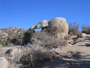
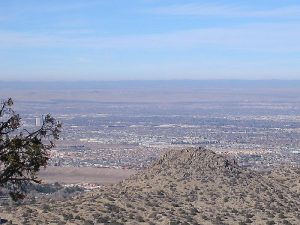
A challenging hike for winter months with only a short drive. Views all around Albuquerque.
CautionsHiking poles recommended.
Trailhead Directions
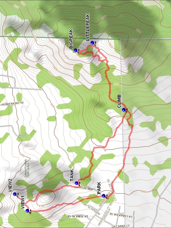
I-40 east to the Tramway Blvd off ramp. Take Tramway south across Central where shortly Tramway will curve to the east for approximately a quarter of a mile. There, Tramway dead ends at Four Hills Drive. Go south on Four Hills Drive, which drops down into the Tijeras Arroyo and up the south slope of the Arroyo to a “Y”. At the “Y” take the left (east) branch, which becomes Stagecoach Rd. SE. Continue east on Stagecoach Rd. for a mile or so, until Stagecoach Rd. makes a sharp 90 degree turn (almost a dead end) to the south. Continue south on Stagecoach Rd. for six/seven blocks where it curves to the east for several blocks. At that point Stagecoach Rd. dead ends at the entrance/gate of the Manzano Open Space. PARK (0.0 mi) at the curb on either side of the street.
Actual Hike
From parking go north around a little hill to two views of the west and north to I-40 (VIEW1 (0.6 mi) and VIEW2 (0.75 mi), then south to the big water TANK (1.25 mi) and then southeast. You’ll think this is a really easy hike until you reach CLIMB (2.0 mi). Hikers who don’t want to hike up and down 500 ft at a grade of up to 16% should wait here. Otherwise, keep going uphill to LITTLEPEAK (2.6 mi), then slog on up BIGPEAK (2.7 mi). Eat your lunch here or head back down a little way to get out of the wind. Return to CLIMB then take one of the southern trails back to parking. The southern boundary is with Kirtland AFB. The trails themselves are mostly rutted bike trails or old roads.
Comments
We have great views of I-40 in Tijeras Canyon, the Mesa del Sol movie studio complex, the E-W airport runway, the border fence of Kirtland Air Force Base, and Mt. Taylor.
WaypointsPARK: N35 02.748, W106 28.931
VIEW1: N35 03.202, W106 29.040
VIEW2: N35 03.277, W106 28.921
TANK: N35 02.910, W106 28.841
CLIMB: N35 02.629, W106 28.307
LITTLEPEAK: N35 02.816, W106 27.821
BIGPEAK: N35 02.916, W106 27.876
Hike GPS File Name: ManzanoOpenSpaceWayTrack_MW.gpx
Hike GPS File: Click link to download hike waytrack file
Text Author: Jim Giachino
Map Author: Marilyn Warrant
Waypoints Author: Marilyn Warrant
Track Author: Marilyn Warrant
Maintainer: Cathy Intemann
Editor: Howard Carr