Trail Canyon Hike
In Manzano Mountains East Region
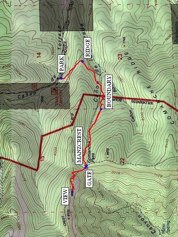
Map File Source: NG Topo
 Hike Key: H10196
Last Updated: 12/15/2020 12:00am
Last Updated By: Marilyn Warrant
Hike Class: C (Challenging)
Hike Distance: 3.9 mi
Minimum Elevation: 7500 ft
Elevation Change: 1097 ft
Total Uphill: 1100 ft
Total Downhill: 1100 ft
Avg. Grade: 12 %
Route Type: InOut
On Trail: Yes
Paved or Gravel Roads: No
GPS Advised: No
Drive Distance Round Trip: 120 mi
Drive Time One-Way: 1:30
Hiking Seasons:
New Mexico Game Unit: 14
Hike Status: Published
Highlights
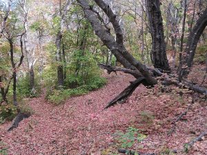
Forest hike in the Rocky Mountain maples that are beautiful in the fall.
CautionsSteep, so hiking poles recommended.
Trailhead Directions
I-40 east to Tijeras exit 175. South on 337 (14) to its end (mile 0). West on SR 55 to Tajique and on to Torreon. At the far end of Torreon turn right onto La Questa Street (red roofs). There is also a sign there: “SUFI Foundation of America Retreat Center.” Then immediately take a right onto (what may be unnamed) FR 55 (yes, SR 55 and FR 55 have the same number). It also is called Tajique-Torreon Loop Road. You will come to a tee with a white pipe fence and a pillar with a golden lion on top. That is the Sufi Center. Turn right there. In just a few minutes you will pass over two cattle guards and see sign: “Cibola Forest.” Watch for the trailhead sign for Trail Canyon Trail. Drive across stream and PARK (0.0 mi) near the mapboard.
Actual Hike
The trail goes south over a small RIDGE (0.3 mi) and down into the canyon on the other side. Then the trail goes up the canyon, comes to the wilderness BOUNDARY (0.9 mi), and then to the intersection of the Trail Canyon Trail, Comanche Trail, and Manzano Crest Trail 170 at MANCREST. At this point you may have some who would rather go left (south) for a couple hundred yards to an overlook for lunch and wait for the rest to come back. Turn north (right) on Crest Tr. where just to the right is Comanche Canyon Tr.182 going down the other side. Just beyond that is a fence. Go through the GATE (1.6 mi). If you’re fortunate, someone has been before you recently with loppers and you can get through the oaks and locust bushes. Climb up steeply using five switchbacks for lunch on a steep cliff overlooking Comanche Canyon at VIEW (2.0 mi). Look south to Capilla Peak. Breathtaking vista! Return the way you came.
Comments
Trail Canyon is shown as “Canon de la Vereda” on the Manzano map. Vereda is Spanish for path, or trail. At Crest Trail, there are signs (that may be lying down) that say Capilla Peak is 3 miles south, Bosque Peak Trail is 3 miles to the north and a few paces to the north more signs indicate that JFK Campground is 4 miles via Comanche Trail going down the west side. Go to the trailhead via Tajique, even though Torreon is closer.
WaypointsPARK: N 34 44.577, W 106 23.386
RIDGE: N 34 44.394, W 106 23.213
BOUNDARY: N 34 44.238, W 106 23.703
MANZCREST: N 34 44.359, W 106 24.291
GATE: N 34 44.368, W 106 24.311
VIEW: N 34 44.484, W 106 24.563
Hike GPS File Name: TrailCanyonWayTrack_BGBG.gpx
Hike GPS File: Click link to download hike waytrack file
Text Author: Roger Holloway
Map Author: Marilyn Warrant
Waypoints Author: Bill Gloyd
Track Author: Bill Gloyd
Maintainer: Bill Gloyd
Editor: Marilyn Warrant