Cieneguilla Petroglyphs Hike
In Santa Fe Region
Map File Source: Other
 Hike Key: H10156
Last Updated: 12/15/2020 12:00am
Last Updated By: Marilyn Warrant
Hike Class: B (Moderate)
Hike Distance: 1.5 mi
Minimum Elevation: 6130 ft
Elevation Change: 100 ft
Total Uphill: 100 ft
Total Downhill: 100 ft
Avg. Grade: 4 %
Route Type: InOut
On Trail: No
Paved or Gravel Roads: Yes
GPS Advised: No
Drive Distance Round Trip: 100 mi
Drive Time One-Way: 1:00
Hiking Seasons: Spring, Fall, and Winter
New Mexico Game Unit: 6C
Hike Status: Published
Highlights
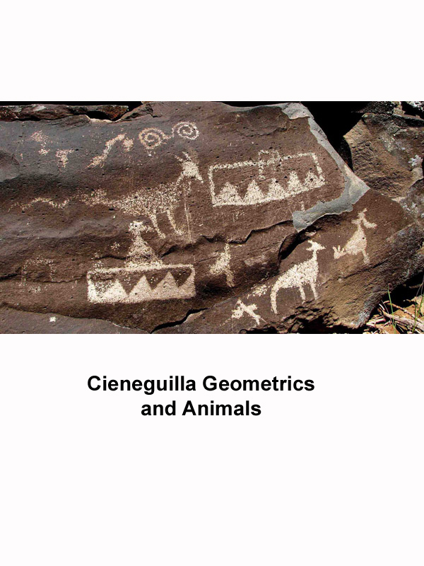
A great gallery of petroglyphs along the edge of a black rock mesa. Panoramic views of the Sandia, San Pedro, Ortiz, and Sangre de Cristo Mountains, with the Santa Fe River below.
CautionsHiking poles recommended for rock scramble to reach the petroglyphs, careful footing along the galleries, and then a rock scramble descent.
Trailhead Directions
I-25 north to La Cienega Exit 271. Go north 1 mile on Entrada La Cienega (NM 587) past town of La Cienega. Follow Los Pinos Road northeast; it becomes CR 56 (Paseo Real). You will see a small white church off to the left. Continue to where road goes to right (north). Park at PARK-GLYPHS in the fenced BLM parking area on the left.
Actual Hike
Walk 0.1 mile west on a well-defined path, then left along a fence at the junk yard tree (CANDOTREE), following the trail south. After crossing an arroyo bear right at TURN1 (0.3 mi) and pass through a GATE (0.4 mi), then head up the escarpment to PANEL (0.5 mi). The petroglyph galleries are along the trail just below the rim. For the most impressive images, follow the trail to the left along the petroglyph gallery until you reach a major rock slide. Head DOWN (0.75 mi) the escarpment at this point and follow along the fence until you rejoin the original trail.
Comments
A great gallery of petroglyphs along the edge of a black rock mesa. Panoramic views of the Sandias, San Pedros, Ortiz, and (snow-capped?) Sangre de Christo Mountains and the Santa Fe River below. The hike entails a rock scramble up to reach the petroglyphs, then careful footing along the galleries and a rock scramble descent. Hiking sticks may be helpful.
Hike class raised to B due to the steep parts.
WaypointsPARK-GLYPHS: N35 36.535, W106 07.193
CANDOTREE: N35 36.544, W106 07.296
TURN1: N35 36.361, W106 07.348
GATE: N35 36.296, W106 07.374
PANEL: N35 36.304, W106 07.429
DOWN: N35 36.127, W106 07.518
Hike GPS File Name: CieneguillaPetroglyphsFixWayTrack_KSKS.gpx
Hike GPS File: Click link to download hike waytrack file
Text Author: Roger Holloway
Map Author: Bob Schwartz
Waypoints Author: Ken Smith
Track Author: Ken Smith
Maintainer: Not Assigned
Editor: Marilyn Warrant