10K – Survey Loop Hike
In Sandia Mountain East Region
Map File Source: DeLorme
 Hike Key: H10141
Last Updated: 03/20/2023 2:07pm
Last Updated By: Marilyn Fixer
Hike Class: C (Challenging)
Hike Distance: 5.7 mi
Minimum Elevation: 9645 ft
Elevation Change: 775 ft
Total Uphill: 1020 ft
Total Downhill: 1020 ft
Avg. Grade: 9 %
Route Type: CCW Loop
On Trail: Yes
Paved or Gravel Roads: Yes
GPS Advised: No
Hiker Limit (NF/BLM/NP): 15 (Sandia Wilderness)
Drive Distance Round Trip: 60 mi
Drive Time One-Way: 1:00
Hiking Seasons: Spring, Summer, and Fall
New Mexico Game Unit: 8
Hike Status: Published
Attractions: Fall Color, Forest, and Meadows
Highlights
A good late spring, summer or fall hike
CautionsNone.
Trailhead Directions
From Albuquerque take I-40 east to Tijeras exit. North on NM 14, west on Crest Road SR-536. PARK (0.0 mi) at the 10K trailhead turnoff on the right just past mile marker 10. A three dollar fee or Golden Age Pass is required.
Actual Hike
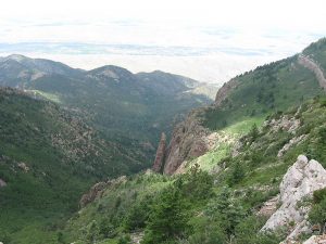
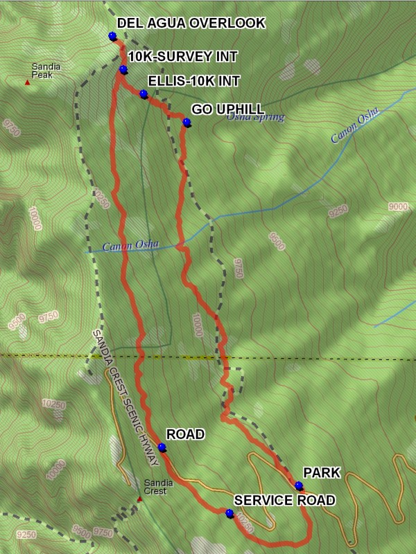
Go to the north end of the parking lot where the 10K trail starts. The trail goes northward with ups and downs, losing altitude for 2.1 miles. GO UPHILL (2.0 mi) at this point where there is a trail going down hill. This trail goes to Osha Spring, an arduous down and back up side trip. After another 0.3 miles the ELLIS-10K INT (2.3 mi) is reached. Continue uphill for 0.1 miles to the 10K-SURVEY INT (2.5 mi). This intersection is important for the return trip. Remember it. Continue uphill to the ridge where the 10K trail meets the Crest Trail. Continue to the DEL AGUA OVERLOOK (2.7 mi) ahead for a great view to the west and north. In the fall there will be a colorful large stand of aspen on the northwest facing slope to the left. This stand is easily visible from the valley below in the Fall. This is a good spot for lunch.
Return to the 10K-SURVEY INT (2.5 mi) and turn right onto the Survey Trail. This is a pleasant soft surfaced shaded trail which gains elevation for the next 2 miles at which point the paved ROAD (4.7 mi) is reached. Cross the road and take the trail downward for about 0.5 miles to where the SERVICE ROAD (5.1 mi) is reached. Go left on the service road to the Ellis Trailhead parking lot. Go to the southeast corner of the lot and find a two track leading downhill. This track will meet with the trail which is the end part of the 10K South – Crest hike. Follow this trail which will continue downward, then north to the 10K parking lot.
Waypoints
PARK: N35 12.585, W106 26.139
GO UPHILL: N35 13.952, W106 26.654
ELLIS-10K INT: N35 14.057, W106 26.852
10K-SURVEY INT: N35 14.150, W106 26.945
DEL AGUA OVERLOOK: N35 14.276, W106 26.996
ROAD: N35 12.729, W106 26.768
SERVICE ROAD: N35 12.481, W106 26.457
Hike GPS File Name: 10K-SurveyLoopWayTrack_DBDB.gpx
Hike GPS File: Click link to download hike waytrack file
Text Author: Dick Brown
Map Author: Marilyn Warrant
Waypoints Author: Dick Brown
Track Author: Dick Brown
Maintainer: Not Assigned
Editor: Marilyn Warrant