Otero Canyon West Loop Hike
In Cedro Peak Region
Map File Source: NG Topo
 Hike Key: H10134
Last Updated: 06/29/2021 12:00am
Last Updated By: Marilyn Fixer
Hike Class: C (Challenging)
Hike Distance: 4.9 mi
Minimum Elevation: 6762 ft
Elevation Change: 593 ft
Total Uphill: 728 ft
Total Downhill: 728 ft
Avg. Grade: 5 %
Route Type: CCW Loop
On Trail: Yes
Paved or Gravel Roads: Yes
GPS Advised: No
Drive Distance Round Trip: 40 mi
Drive Time One-Way: 0:45
Hiking Seasons: Spring, Summer, and Fall
New Mexico Game Unit: 14
Hike Status: Published
Highlights
A well-marked forested trail along the ridges of the Manzanita Mountain foothills close to Albuquerque.
CautionsIn winter, the trail may be covered with snow/ice. Therefore, hike trekking poles and/or boot traction devices are highly recommended.
Trailhead Directions
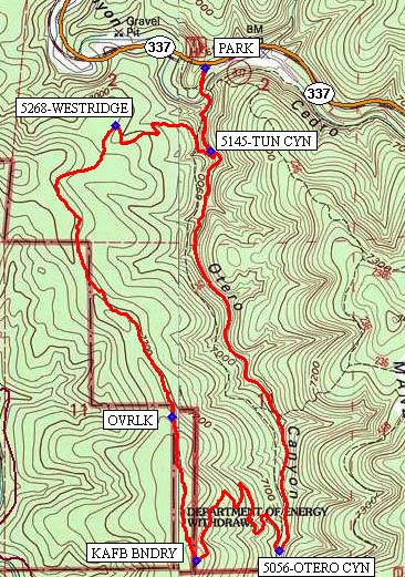
From Albuquerque take I-40 east. Take exit 175 south to Tijeras. From the traffic light in Tijeras go south on NM 337 (Old Highway 14) for 4 miles to Otero Canyon, PARK (0.0 mi) on the right.
Actual Hike
For a short distance the hikers follow an old road which is the start of Otero Canyon trail (#5056) going south. Make an abrupt right turn (west) at 5145-TUN CYN (0.4 mi) where the trail goes uphill, right up the side of the canyon. Continue on the trail until the intersection with 5268-WESTRIDGE (0.8 mi) where you turn left (southwest). Turn around at OVRLK (1.9 mi) for a view looking northward toward the Sandias and I-40. At KAFB BNDRY (2.4 mi) turn left (east) heading into Otero Canyon. For the next half mile, there may be a good spot for lunch. Then at 5056-OTERO CYN (2.9 mi), turn left (north) to follow the Otero Canyon trail back to the van.
Comments
The Otero Canyon West Loop hike trails are shown close to the middle-left of the Manzanita Mountains Trail System map.
Hike data were determined using a Garmin GPSMap 62 and Garmin BaseCamp’s DEM for TOPO US 24K Southwest.
WaypointsPARK: N35 02.085, W106 22.453
5145-TUN CYN: N35 01.864, W106 22.435
5268-WESTRIDGE: N35 01.933, W106 22.740
OVRLK: N35 01.162, W106 22.561
KAFB BNDRY: N35 00.782, W106 22.484
5056-OTERO CYN: N35 00.806, W106 22.212
Hike GPS File Name: OteroCynWestLp_BG.gpx
Hike GPS File: Click link to download hike waytrack file
Text Author: Bill Gloyd
Map Author: Bill Gloyd
Waypoints Author: Bill Gloyd
Track Author: Bill Gloyd
Maintainer: Bill Gloyd
Editor: Marilyn Warrant