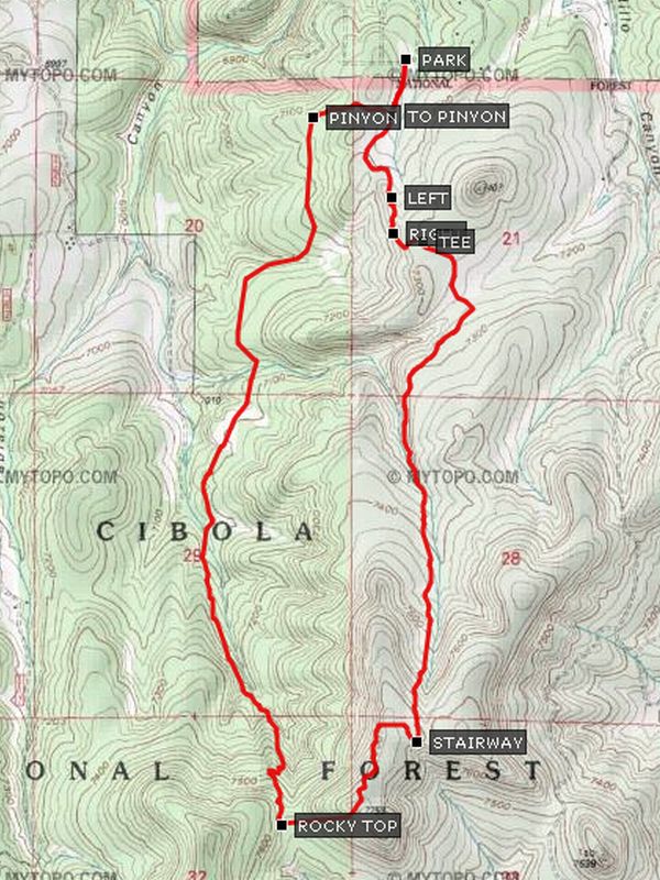
Five Hills – Rocky Top Hike
In Cedro Peak Region
Map File Source: GPS Visualizer
 Hike Key: H10126
Last Updated: 12/15/2020 12:00am
Last Updated By: Marilyn Warrant
Hike Class: C (Challenging)
Hike Distance: 6.3 mi
Minimum Elevation: 7025 ft
Elevation Change: 725 ft
Total Uphill: 750 ft
Total Downhill: 750 ft
Avg. Grade: 6 %
Route Type: Loop
On Trail: Yes
Paved or Gravel Roads: Yes
GPS Advised: No
Drive Distance Round Trip: 50 mi
Drive Time One-Way: 0:45
Hiking Seasons: Spring, Summer, and Fall
New Mexico Game Unit: 14
Hike Status: Published
Highlights
There are good southerly views from Rocky Top.
CautionsNone.
Trailhead Directions
From Albuquerque take I-40 west through Tijeras Canyon to exit 178. Exit south and go east on SR 333 for 2 miles to Sedillo Road. Go right onto Sedillo Road and go for about two tenths of a mile. Go right onto Five Hills Road and go about 1.8 miles to the end where the dirt road turns right the road straight ahead is a two track and PARK (0.0 mi).
Actual Hike
From parking go south to TO PINYON (0.2 mi) and go right up over the ridge and down the east side to PINYON (0.4 mi). Go left and go due south. At STRAIGHT start a climb up a narrowing canyon. The trail becomes steep before arriving at a good lunch spot on a saddle just before ROCKY TOP. After this point descend a few hundred feet to the intersection with ROCKY TOP (3.0 mi) Trail on the left. Take Rocky Top Trail which climbs steeply to the highest point on the hike, with good views to the south. The trail meets the STAIRWAY (3.7 mi) to Heaven trail (unmarked). Go left (north) and go to a TEE (5.5 mi). Turn left. This trail traverses downhill to a sharp bend downhill. Go RIGHT (5.6 mi), reaching a bend in a two track. Go LEFT (5.8 mi) and follow the road to parking.
Comments
There are good southerly views from Rocky Top.
WaypointsPARK: N35 05.129, W106 18.629
TO PINYON: N35 04.979, W106 18.673
PINYON: N35 04.972, W106 18.932
ROCKY TOP: N35 03.075, W106 19.038
STAIRWAY: N35 03.297, W106 18.592
TEE: N35 04.639, W106 18.574
RIGHT: N35 04.664, W106 18.671
LEFT: N35 04.760, W106 18.673
Hike GPS File Name: FiveHills-RockyTopWayTrack_DBDB_mod.gpx
Hike GPS File: Click link to download hike waytrack file
Text Author: Dick Brown
Map Author: Marilyn Warrant
Waypoints Author: Dick Brown
Track Author: Dick Brown
Maintainer: Bill Gloyd
Editor: Marilyn Warrant