Rocky Top – Poker Chip Hike
In Cedro Peak Region
Map File Source: NG Topo
 Hike Key: H10124
Last Updated: 06/29/2021 12:00am
Last Updated By: Marilyn Fixer
Hike Class: C (Challenging)
Hike Distance: 5.6 mi
Minimum Elevation: 7280 ft
Elevation Change: 480 ft
Total Uphill: 793 ft
Total Downhill: 793 ft
Avg. Grade: 7 %
Route Type: CCW Loop
On Trail: Yes
Paved or Gravel Roads: Yes
GPS Advised: No
Drive Distance Round Trip: 45 mi
Drive Time One-Way: 0:45
Hiking Seasons: Spring, Summer, and Fall
New Mexico Game Unit: 14
Hike Status: Published
Highlights
This enjoyable hike courses through mostly wooded hills and meadows, flowers galore.
CautionsThere are rocky and steep sections on this hike.
Trailhead Directions
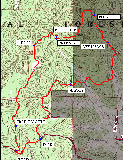
From Albuquerque take I-40 west, take exit 175 south to Tijeras. From the traffic light in Tijeras follow the following odometer readings. At 0.0, go south on NM 337 (Old Highway 14). At 5.0, turn left (east) on Juan Tomas Road. At 7.5 miles, PARK (0.0 mi) on the south side of the road.
Actual Hike
Cross the road and take Bear Scat trail north to a post marked, HARRYS (1.1 mi) trail. Take the right turn there, leaving the Bear Scat trail. This section of the hike enters private land (but for practical purposes, public trails) and passes through a combination of open and wooded terrain.
You will come to an open fence, where the trail enters the Bernalillo County OPEN SPACE (2.1 mi). This section begins to be rocky and steep all the way up to ROCKY TOP (2.5 mi). In a number of places, the trail is unmarked, obscure and easily missed, but is followed without difficulty once found. There are several view points along the Rocky Top.
The trail then drops down on a steep rocky section and reconnects with the BEAR SCAT (3.3 mi) trail at a well-marked “T” in the path. Take a right, going uphill a short distance to the saddle and turn left at the marked trail POKER CHIP (3.3 mi).
This section gains elevation to the highest point on the hike at 7760 feet. Along this section there are a number of view opportunities to the south and of the Sandias. Have LUNCH (3.7 mi) up here. After about a mile the trail drops down and you are redirected by a TRAIL REROUTE (4.8 mi) sign. Follow the trail to the ROAD (5.2 mi). From that point, it is a third of a mile walk to the parking lot.
Waypoints
PARK: N35 02.082, W106 19.226
HARRYS: N35 02.619, W106 18.871
OPEN SPACE: N35 03.033, W106 18.418
ROCKY TOP: N35 03.298, W106 18.585
BEAR SCAT: N35 03.298, W106 18.585
POKER CHIP: N35 03.098, W106 19.039
LUNCH: N35 03.001, W106 19.308
TRAIL REROUTE: N35 02.208, W106 19.527
ROAD: N35 02.208, W106 19.527
Hike GPS File Name: RkyTop_PokerChip0140509_1.gpx
Hike GPS File: Click link to download hike waytrack file
Text Author: Bill Gloyd
Map Author: Bill Gloyd
Waypoints Author: Bill Gloyd
Track Author: Bill Gloyd
Maintainer: Bill Gloyd
Editor: Marilyn Warrant