Crest Trail – Survey Trail Loop Hike
In Sandia Mountain East Region
Map File Source: DeLorme
 Hike Key: H10122
Last Updated: 03/20/2023 2:13pm
Last Updated By: Marilyn Fixer
Hike Class: C (Challenging)
Hike Distance: 5.7 mi
Minimum Elevation: 9930 ft
Elevation Change: 720 ft
Total Uphill: 1015 ft
Total Downhill: 1015 ft
Avg. Grade: 8 %
Route Type: Loop
On Trail: Yes
Paved or Gravel Roads: Yes
GPS Advised: No
Hiker Limit (NF/BLM/NP): 15 (Sandia Wilderness)
Drive Distance Round Trip: 60 mi
Drive Time One-Way: 1:00
Hiking Seasons: Spring, Summer, and Fall
New Mexico Game Unit: 8
Hike Status: Published
Highlights
Forest walk with views to the west and northwest.
CautionsSome rocky stretches on the Crest Trail.
Trailhead Directions
From Albuquerque go east on I-40 to the SR 14 exit and go north to Cedar Crest. At SR 536 turn left and go up the crest road 11.7 miles to The Ellis Trailhead parking on your left. A three dollar fee or Golden Age Pass is required.
Actual Hike
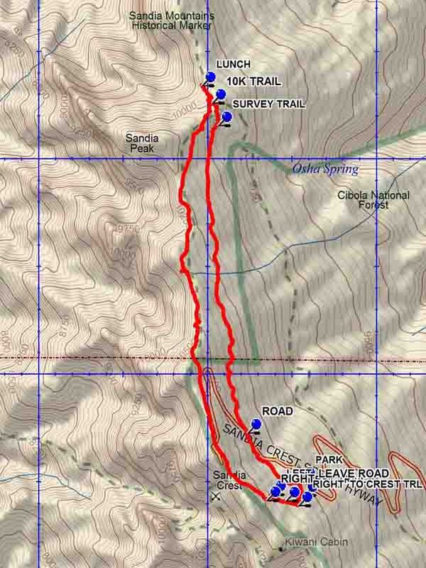
Go south from parking on the tram service road to LEAVE ROAD (0.1 mi) and take the trail uphill to a Y intersection and go RIGHT TO CREST TRL (0.2 mi). The trail meets the Crest Trail at CREST TRAIL (0.2 mi). Turn right onto the Crest Trail and go about 300 feet at which point the Crest Trail turns uphill at LEFT (0.3 mi). After 300 feet the Crest trail meets a “road”. Go RIGHT (0.4 mi). Continue on the road to the lower Crest parking lot. Walk north on the parking lot and across the paved road, where the Crest Trail is picked up again. It is about 2.5 miles to the LUNCH (3.1 mi) spot from this point. To go back return to the 10K TRAIL (3.2 mi) intersection. Go left and down hill to the intersection with the SURVEY TRAIL (3.4 mi) and go right on that trail. This trail gains elevation at a moderate rate and reaches the state ROAD (5.2 mi). The Survey Trail officially ends here. Cross the highway and go downhill on the trail to where there is a branch. The parking lot will be in sight. Bear left and continue downhill to the service road and go left to the parking lot.
Comments
Going slow on the uphill will make this hike easier. The trails in the woods are smooth and “soft”, but portions of the Crest Trail are quite rocky. A good summer hike, away from the heat of the city.
WaypointsPARK: N35 12.504, W106 26.452
LEAVE ROAD: N35 12.438, W106 26.436
CREST TRAIL: N35 12.412, W106 26.543
RIGHT TO CREST TRL: N35 12.390, W106 26.466
LEFT: N35 12.442, W106 26.625
RIGHT: N35 12.415, W106 26.656
LUNCH: N35 14.342, W106 27.039
10K TRAIL: N35 14.262, W106 26.978
SURVEY TRAIL: N35 14.156, W106 26.942
ROAD: N35 12.729, W106 26.768
Hike GPS File Name: CrestTrail-SurveyTrailLoopWayTrack_DBDB.gpx
Hike GPS File: Click link to download hike waytrack file
Text Author: Dick Brown
Map Author: Dick Brown
Waypoints Author: Dick Brown
Track Author: Dick Brown
Maintainer: Ken Smith
Editor: Marilyn Warrant