Mahogany-Gamble Oak Loop Hike
In Cedro Peak Region
Map File Source: Garmin BaseCamp
 Hike Key: H10108
Last Updated: 12/15/2020 12:00am
Last Updated By: Marilyn Warrant
Hike Class: C (Challenging)
Hike Distance: 7.6 mi
Minimum Elevation: 7245 ft
Elevation Change: 281 ft
Total Uphill: 740 ft
Total Downhill: 740 ft
Avg. Grade: 4 %
Route Type: Lollypop
On Trail: Yes
Paved or Gravel Roads: Yes
GPS Advised: No
Drive Distance Round Trip: 45 mi
Drive Time One-Way: 0:45
Hiking Seasons: Spring, Summer, and Fall
New Mexico Game Unit: 14
Hike Status: Published
Highlights
A pleasant ramble through the Gamble Oak woods on forest trails over varied terrain.
CautionsNone.
Trailhead Directions
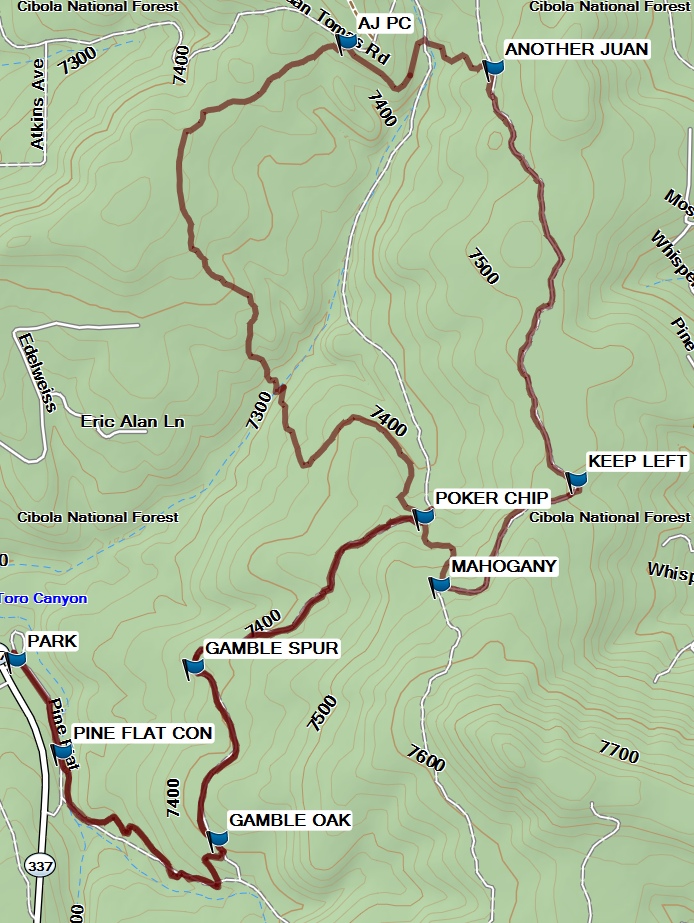
Go east on I-40 through Tijeras Canyon and take exit 175 south to SR 330. Go south through the traffic light for 6.9 miles to the Pine Flats picnic area on the left. PARK (0.0 mi) at the south end of the area.
Actual Hike
Walk a short distance to the PINE FLAT CON (0.2 mi) (PF Connector) trailhead. Follow the woodsy trail to the intersection with GAMBLE OAK (0.9 mi). Turn left and hike slightly up hill passing GAMBLE SPUR (1.3 mi) on to the intersection with POKER CHIP (1.9 mi), where you will turn right to begin the counterclockwise loop of the popsicle pattern. Keep left at MAHOGANY (2.1 mi) and continue a slight uphill climb where you will KEEP LEFT (2.5 mi). Here the trail goes in and out of a two-track road. Any place along here (or farther on) would be a good place for lunch.
Find the sign for ANOTHER JUAN (3.5 mi) and turn left. Follow the well-marked trail past AJ PC to the stick of the popcycle at POKER CHIP (5.5 mi), where you will back track over the early part of the hike. Take a right turn here, passing GAMBLE OAK (6.6 mi) and PINE FLAT CON (7.3 mi) back to the van at PARK (7.6 mi).
Comments
The Mahogany Gamble Oak Loop hike trails are shown in the lower right part of the Manzanita Mountains Trail System map. Note that most of our waypoint names match the trail names on the above mentioned map.
Hike data were determined using a Garmin GPSMap 62 and Garmin BaseCamp’s DEM for TOPO US 24K Southwest.
WaypointsPARK: N35 00.871, W106 20.227
PINE FLAT CON: N35 00.712 W106 20.128
GAMBLE OAK: N35 00.561, W106 19.791
GAMBLE SPUR N35 00.858, W106 19.842
POKER CHIP: N35 01.118, W106 19.344
MAHOGANY: N35 01.000, W106 19.310
KEEP LEFT: N35 01.183, W106 19.015
ANOTHER JUAN: N35 01.898, W106 19.193
AJ PC: N35 01.943, W106 19.511
Hike GPS File Name: Mahogany-GambleOakWayTrackRed2_BGMW.gpx
Hike GPS File: Click link to download hike waytrack file
Text Author: Bill Gloyd
Map Author: Marilyn Warrant
Waypoints Author: Bill Gloyd
Track Author: Bill Gloyd
Maintainer: Bill Gloyd
Editor: Dawn McIntyre