Chamisoso Canyon Hike
In Cedro Peak Region
Map File Source: NG Topo
 Hike Key: H10107
Last Updated: 12/15/2020 12:00am
Last Updated By: Marilyn Warrant
Hike Class: B (Moderate)
Hike Distance: 5.5 mi
Minimum Elevation: 6617 ft
Elevation Change: 356 ft
Total Uphill: 727 ft
Total Downhill: 727 ft
Avg. Grade: 5 %
Route Type: InOut
On Trail: Yes
Paved or Gravel Roads: Yes
GPS Advised: No
Drive Distance Round Trip: 40 mi
Drive Time One-Way: 0:45
Hiking Seasons: Spring, Summer, and Fall
New Mexico Game Unit: 14
Hike Status: Published
Highlights
This is a lovely, woodsy hike with a few hills, up and down.
CautionsNone.
Trailhead Directions
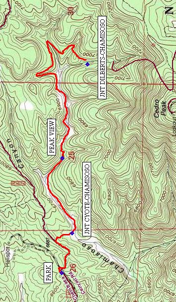
From Albuquerque take I-40 east to the Tijeras exit. Take SR 337 south through the traffic light for about 1.6 miles to Chamisoso Canyon Rd on your left. Take this dirt road east for about 0.6 mile. Park the van in the designated parking area PARK (0.0 mi), where there is a set of restrooms.
Actual Hike
From the parking area walk along the main road (462A) for 250 ft, where you will take a right turn off the main road, up a rocky side road (462) for nearly a third of a mile. At this point you will find four large boulders (used to block vehicular traffic), where you will turn right (south) going downhill for approximately one tenth of a mile to JNT CYOTE-CHAMIOSO (620-184) (0.5 mi). The trails are well-marked with five digit numbers, starting with 05, so the above waypoint is where 05620 and 05184 meet. Turn left and follow the trail to PEAK VIEW (0.7 mi) and on to JNT DILBERTS-CHAMIOSO (622-184) (2.8 mi), where you will turn around, head back and consider a place for lunch.
The trail is a general uphill stroll to the turn-around point, but not noticeably difficult. There are occasional areas of loose rock, but not particularly steep.
Comments
This is a pleasant B hike, very accessible and close to Albuquerque
WaypointsPARK: N35 03.846, W106 22.280
JNT CYOTE-CHAMIOSO: N35 03.784, W106 21.994
PEAK VIEW: N35 03.844, W106 21.456
JNT DILBERTS-CHAMIOSO: N35 03.694 W106 20.782
Hike GPS File Name: CHAMIOSO_CYN02_140505_BG.gpx
Hike GPS File: Click link to download hike waytrack file
Text Author: Bill Gloyd
Map Author: Bill Gloyd
Waypoints Author: Bill Gloyd
Track Author: Bill Gloyd
Maintainer: Bill Gloyd
Editor: Howard Carr