San Ysidro Trials West Hike
In San Ysidro Region
Map File Source: DeLorme
 Hike Key: H10106
Last Updated: 12/15/2020 12:00am
Last Updated By: Marilyn Warrant
Hike Class: B (Moderate)
Hike Distance: 5.2 mi
Minimum Elevation: 5500 ft
Elevation Change: 275 ft
Total Uphill: 325 ft
Total Downhill: 325 ft
Avg. Grade: 3 %
Route Type: Loop
On Trail: No
Paved or Gravel Roads: Yes
GPS Advised: Yes
Drive Distance Round Trip: 70 mi
Drive Time One-Way: 1:15
Hiking Seasons: Spring and Fall
New Mexico Game Unit: 6A
Hike Status: Published
Highlights
Hike on expanses of rock surface with rock formations, through canyons, and by water pools in a arroyo.
CautionsSome walking on rock surfaces.
Trailhead Directions
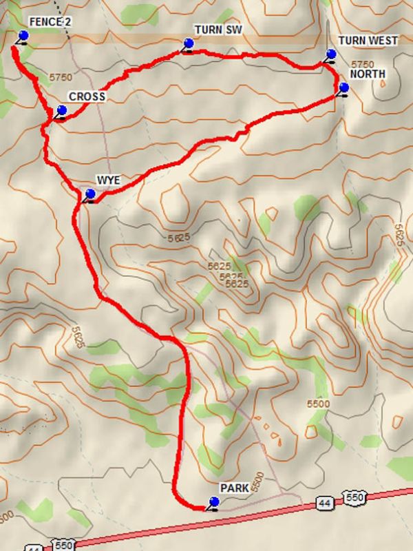
From Albuquerque go North on I-25 to Bernalillo. Go west on US 550 from Bernalillo to milepost 25 which is about 1.5 miles beyond San Ysidro. There is a small parking area beyond the west end of paved pull off area on the right in a fenced parking area marked “San Ysidro Trials”. Pull in there and PARK (0.0 mi).
Actual Hike
There is a fence pass through at the west end of the parking area. Go through the pass through and hike the road which curves to the north and up the hill. The road drops down into an open area before the first arroyo. At this WYE (1.1 mi) bear right and cross the arroyo and follow the path which goes slightly north of East. At 2 miles from the start of the hike a canyon is reached. Turn NORTH (2.0 mi) and hike along or near the east side of the canyon for about 0.1 miles. TURN WEST (2.1 mi), going 0.5 miles before a TURN SW (2.6 mi). This segment of the hike crosses an expanse of rock “pavement” with interesting formations. A second canyon is reached. CROSS (3.1 mi) the canyon. This canyon contains interesting terrain, and pools of water and vegetation even during dry weather. Go north to FENCE 2 (3.4 mi), then return south along and in the canyon until the WYE is reached. Then return to parking on the road.
Comments
This is BLM land. A motorcycle club has an agreement with the BLM to use the area for trials. A series of courses have been laid out in the area. The area is seldom used by the cyclists, who have access to the area on the gated road during events.
WaypointsPARK: N35 33.287, W106 48.414
WYE: N35 34.094, W106 48.811
NORTH: N35 34.372, W106 47.994
TURN WEST: N35 34.458, W106 48.036
TURN SW: N35 34.487, W106 48.496
CROSS: N35 34.311, W106 48.904
FENCE 2: N35 34.509, W106 49.028
Hike GPS File Name: SanYsidroTrialsWestWayTrack_DBDB.gpx
Hike GPS File: Click link to download hike waytrack file
Text Author: Dick Brown
Map Author: Dick Brown
Waypoints Author: Dick Brown
Track Author: Dick Brown
Maintainer: Cindy McConnell
Editor: Howard Carr