East Fork – Las Conchas Hike
In Jemez Mountains Region
Map File Source: DeLorme
 Hike Key: H10105
Last Updated: 03/10/2021 12:00am
Last Updated By: Marilyn Fixer
Hike Class: B (Moderate)
Hike Distance: 4.8 mi
Minimum Elevation: 8030 ft
Elevation Change: 524 ft
Total Uphill: 703 ft
Total Downhill: 400 ft
Avg. Grade: 6 %
Route Type: Oneway
On Trail: Yes
Paved or Gravel Roads: Yes
GPS Advised: Yes
Drive Distance Round Trip: 140 mi
Drive Time One-Way: 1:45
Hiking Seasons: Spring, Summer, and Fall
New Mexico Game Unit: 6A
Hike Status: Published
Highlights
Mountain stream in narrow canyon. Wildflowers, aspens, and rock walls.
CautionsHiking poles recommended.
Trailhead Directions
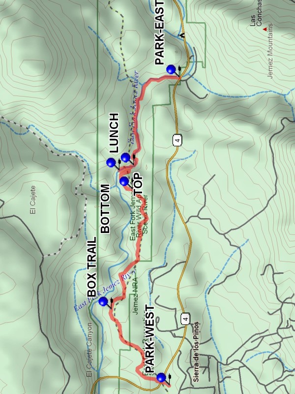
From Albuquerque take I-25 to Bernalillo. At Bernalillo take US 550 to San Ysidro. Take SR 4 north to La Cueva. Stay on SR 4 and go east for 5.5 miles to the point where the highway crosses over the South Fork of the Jemez River. From there it is less than a mile to a small picnic area on the left near the top of the hill where there is parking at PARK-WEST. The trail starts here. If doing the hike from east to west, it is another 4 miles to the parking area on the left before the bridge that re-crosses the river at PARK-EAST (4.8 mi).
Actual Hike
This description is for a west to east hike. The first part of the hike is a steady climb of 530 ft vertical over a distance of 2.8 miles to TOP. At 1.3 miles on this first part of the hike there is a marked trail to the left at BOX TRAIL (1.2 mi). This trail descends to the bottom of the gorge to the river. Do not take this trail unless a climb back out is desired, or even more exciting, a swim to the end of the box near BOTTOM (3.3 mi). The middle part of the hike is a descent to the river at 3.3 miles, BOTTOM (3.3 mi). The last part of the hike is a 1.5 mile walk down “Las Conchas Canyon”. This small canyon is very scenic. There are many crossings of the river on this part, all of them rebuilt as real foot bridges. When going from west to east, there are many nice spots for lunch in the canyon, one of them being LUNCH (3.5 mi). When going from east to west, find a spot in the aspens after the climb out of the canyon to TOP (2.9 mi).
Comments
This hike can be done in either direction. The entire hike requires some kind of shuttle arrangement, or a 10 mile hike. The hike can be done as an out and back hike from either end, going as far as desired before returning. A start from the east end would feature the very scenic “Los Conchas Canyon”, about 1.5 miles long. The start from the west end features aspens in the fall. If only “Las Conchas Canyon” is hiked the elevation change is minimal, an A hike.
WaypointsPARK-WEST: N35 48.996, W106 35.459
BOX TRAIL: N35 49.531, W106 34.594
TOP: N35 49.338, W106 33.232
BOTTOM: N35 49.458, W106 33.020
LUNCH: N35 49.327, W106 32.964
PARK-EAST: N35 48.906, W106 31.966
Hike GPS File Name: EastFork-LasConchasWayTrack_DBDB.gpx
Hike GPS File: Click link to download hike waytrack file
Text Author: Dick Brown
Map Author: Marilyn Warrant
Waypoints Author: Dick Brown
Track Author: Dick Brown
Maintainer: Vivian Heyward
Editor: Marilyn Warrant