Bernalillito Hoodoos Hike
In Ojito Region
Map File Source: DeLorme
 Hike Key: H10099
Last Updated: 12/15/2020 12:00am
Last Updated By: Marilyn Warrant
Hike Class: B (Moderate)
Hike Distance: 4.5 mi
Minimum Elevation: 5770 ft
Elevation Change: 180 ft
Total Uphill: 250 ft
Total Downhill: 250 ft
Avg. Grade: 6 %
Route Type: CCW Loop
On Trail: No
Paved or Gravel Roads: No
GPS Advised: Yes
Drive Distance Round Trip: 100 mi
Drive Time One-Way: 1:15
Hiking Seasons: Spring and Fall
New Mexico Game Unit: 9
Hike Status: Published
Access Description: Ojito Wilderness Area Access
Highlights
Outstanding badlands scenery.
CautionsNone.
Trailhead Directions
From Albuquerque go north on I-25 to Bernalillo. From the intersection of I-25 and US 550 (formerly SR 44) in Bernalillo go northwest on US 550 for 20.9 miles to Cabezon Road. This intersection is about 2 miles before San Ysidro. Turn left onto Cabezon Road. Almost immediately there is a Y in the road, go left. Go west for 10.9 miles to a two track on your right and PARK (0.0 mi).
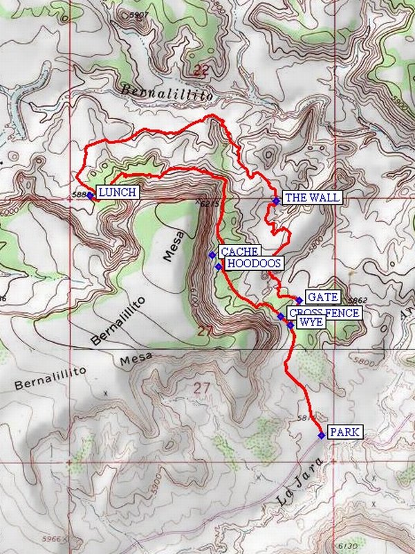
Actual Hike
From parking go north up the road for about 0.2 miles and go straight right at the WYE (0.5 mi) down the path to the GATE (0.6 mi) and pass through the fence. Continue toward the north toward the main Bernalillito Arroyo passing by THE WALL (1.25 mi). Then turn toward the west and go west for about a half a mile then head toward the mesa and into the canyon in the north side of the mesa and find the return trail near the LUNCH (2.6 mi) point. There is a nice view of the area from the lunch spot. Then head back east, following the “trail” which runs along the sloping side of the mesa. The trail will become more distinct as it curves around the mesa end and to the south. After reaching the HOODOOS (3.6 mi) area and the tall pines follow the now well traveled trail to the CROSS FENCE (4.0 mi) point, then on to the WYE (4.0 mi) and the return trail to parking.
Comments
This hike can be done in either direction. Much of the hike is over uneven and sometimes difficult terrain, with no trail to follow. But the scenery in the area is outstanding.
WaypointsPARK: N35 29.721, W106 55.287
WYE: N35 30.085, W106 55.412
GATE: N35 30.166, W106 55.375
THE WALL: N35 30.495, W106 55.470
LUNCH: N35 30.511, W106 56.221
CACHE: N35 30.315, W106 55.727
HOODOOS: N35 30.279, W106 55.700
CROSS FENCE: N35 30.113, W106 55.451
Hike GPS File Name: BernalillitoHoodoosWayTrack_DBDB.gpx
Hike GPS File: Click link to download hike waytrack file
Text Author: Dick Brown
Map Author: Marilyn Warrant
Waypoints Author: Dick Brown
Track Author: Dick Brown
Maintainer: Bill Gloyd
Editor: Marilyn Warrant