Gypsum Slot Canyon Hike
In Ojito Region
Map File Source: DeLorme
 Hike Key: H10093
Last Updated: 12/05/2023 9:26pm
Last Updated By: Marilyn Fixer
Hike Class: C (Challenging)
Hike Distance: 8.6 mi
Minimum Elevation: 5514 ft
Elevation Change: 458 ft
Total Uphill: 845 ft
Total Downhill: 845 ft
Avg. Grade: 4 %
Route Type: Loop
On Trail: No
Paved or Gravel Roads: No
GPS Advised: Yes
Drive Distance Round Trip: 100 mi
Drive Time One-Way: 1:00
Hiking Seasons: Spring, Fall, and Winter
New Mexico Game Unit: 9
Hike Status: Published
Highlights
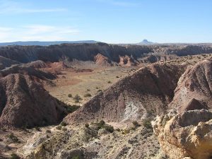
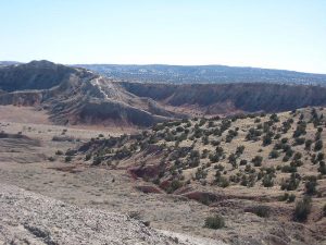
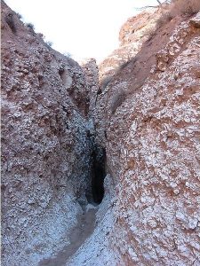
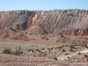
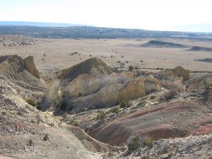
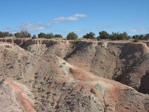
Spectacular scenery of brightly colored cliffs and views in all directions. Short trip through a very narrow slot canyon that has been carved through white gypsum deposits.
CautionsThe canyon may be blocked with tumbleweeds or contain several mud holes, so dress appropriately.
Trailhead Directions
North on I-25, west on 550 from Bernalillo past the Zia Pueblo to Cabezon Rd (milepost 21). Take the left fork (right goes to Gypsum mine). Park 4 miles from 550 turn-off at the White Mesa Bike Tail parking lot (new 2007).
Actual Hike
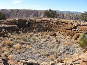
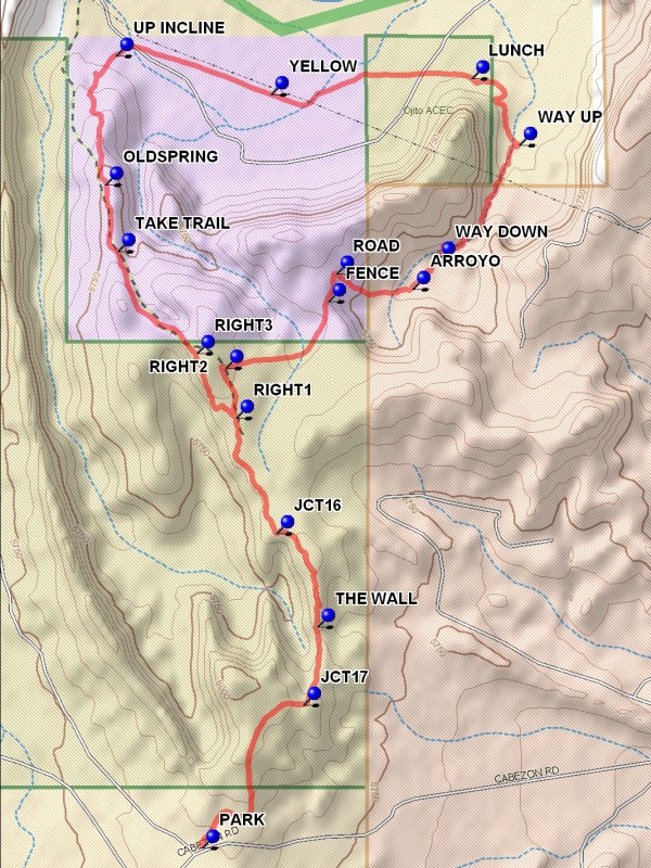
From the parking lot, hike east on a dirt road about 1/2 mi. to bike trails that lead along the east-side ridge that overlooks the valley. You’ll go by JCT17 (0.7 mi), what Roger Holloway called THE WALL (1.0 mi), and JCT16 (1.4 mi). At RIGHT1 (1.8 mi) and RIGHT2 (2.0 mi), follow the dirt road away from the bike trails to the northeast and then to the east to a step-over FENCE (2.5 mi). Find the steep dirt ROAD (2.6 mi) that descends into the valley to the east that contains the slot canyon. At the bottom, hike down an ARROYO (2.9 mi) that leads down to the slot canyon WAY DOWN (3.0 mi) (scrambling is required to get from the first arroyo to the slot canyon arroyo). Depending on the season you may encounter mud, tumbleweeds, and winter snow and ice. The actual gypsum slot is about one hundred yards long, very narrow but always open above you. You will encounter a log wedged part way through the slot that is a struggle to pass, about one quarter mile. After exiting the slot, find a slope on your left that you can scramble up and out of the arroyo (WAY UP (3.6 mi)). Hike cross-country around the corner on your left (west) and find a sheltered nook for LUNCH (4.0 mi) on the north side of the formation. Continue in a westerly direction.to a fence with a gate (near YELLOW (4.7 mi)-painted posts that were installed as petroleum pipeline markers). Continue on a dirt road to the north end of the TA Anticline. Ascend the TA Anticline (UP INCLINE (5.2 mi)) passing numerous mineral springs such as OLD SPRING and find a bike trail TAKE TRAIL (6.0 mi) that leads to the south, then to the southeast, and eventually to the bike trails that lead back to the parking lot.
Comments
This is a strenuous hike because of the distance, some steep declines and inclines, and some scrambling into and out of the arroyo that contains the Gypsum Slot. The scenery is spectacular with brightly colored cliffs and views to the West of the White Mesa bike/hike trail and Cabezon peak, the gypsum mine to the east, the Jemez and Sandia Mountains, the Rio Salado valley and the very narrow slot canyon that has been carved through white gypsum deposits.
WaypointsPARK: N35 29.914, W106 50.489
JCT17: N35 30.323, W106 50.129
THE WALL: N35 30.549, W106 50.081
JCT16: N35 30.817, W106 50.226
RIGHT1: N35 31.148, W106 50.368
RIGHT2: N35 31.292, W106 50.405
FENCE: N35 31.483, W106 50.041
ROAD: N35 31.563, W106 50.015
ARROYO: N35 31.518, W106 49.745
WAY DOWN: N35 31.602, W106 49.657
WAY UP: N35 31.932, W106 49.367
LUNCH: N35 32.123, W106 49.534
YELLOW: N35 32.078, W106 50.244
UP INCLINE: N35 32.188, W106 50.791
OLDSPRING: N35 31.818, W106 50.829
TAKE TRAIL: N35 31.626, W106 50.786
RIGHT3: N35 31.333, W106 50.506
Hike GPS File Name: GypsumSlotCanyonWayTrack_MWMW.gpx
Hike GPS File: Click link to download hike waytrack file
Text Author: John Holmes
Map Author: Marilyn Warrant
Waypoints Author: Marilyn Warrant
Track Author: Marilyn Warrant
Maintainer: Randy Simons
Editor: Howard Carr