Continental Divide To Deadman Peaks Hike
In Cabezon Region
Map File Source: DeLorme
 Hike Key: H10092
Last Updated: 03/23/2021 12:00am
Last Updated By: Marilyn Fixer
Hike Class: B (Moderate)
Hike Distance: 5.5 mi
Minimum Elevation: 6360 ft
Elevation Change: 420 ft
Total Uphill: 550 ft
Total Downhill: 410 ft
Avg. Grade: 4 %
Route Type: Oneway
On Trail: Yes
Paved or Gravel Roads: No
GPS Advised: Yes
Drive Distance Round Trip: 150 mi
Drive Time One-Way: 1:30
Hiking Seasons: Spring, Fall, and Winter
New Mexico Game Unit: 7
Hike Status: Published
Access Description: Cabezon Area Access
Highlights
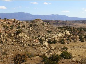
Sandstone formations, mesa views and the ever present Cabezon.
CautionsSome of this hike is over rough terrain.
Trailhead Directions
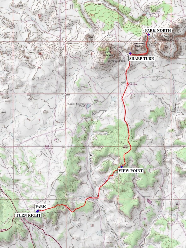
From Albuquerque take I-25 north to Bernalillo. Take US 550 to San Ysidro. Drive west 18 mi. past intersection of SR 4 and US 550 to San Luiz Rd. Turn left and drive 8.5 miles to Torreon Rd. on the right. Turn right onto TORREON RD and drive 3.6 miles to a cattle guard. There the paved road turns into a dirt road. Continue 0.1 mile on the dirt road, TURN RIGHT at the intersection and PARK (0.0 mi) along the side road. The shuttle vehicle proceeds on the dirt road for 3.5 miles to a left bend in the road after the top of the hill beyond the peaks. Turn right onto a two track and go 0.1 miles to the gate at PARK-NORTH (5.4 mi).
Actual Hike
The trail is marked by cairns. It is important to use these as a guide, as it is easy to stray from the “trail”. The trail drops down to a lower level, with interesting formations along the way. After passing an old windmill the trail climbs steeply to a small mesa top where there are great views of the formations down the Rio Puerco valley to the south. This is a good place for lunch. Then continue north to a road junction where the CDT follows the road for a short distance. The trail then veers away from the road and ascends to an upper ledge of one of the Deadman peaks. There are vista views to the south as the trail curls around the peak to a saddle. At this point leave the CDT and go north on a rough two track to PARK-NORTH.
Comments
This hike requires at least 2 people who will take the van to the north end of the hike, after dropping off the rest of the hikers at the south end of the hike. The two hikers will return to the van with the main group when they meet during the hike.
WaypointsTORREON RD: N35 40.177, W107 03.665
TURN RIGHT: N35 42.486, W107 06.312
PARK: N35 42.502, W107 06.289
VIEW POINT: N35 43.225, W107 04.596
SHARP TURN: N35 45.106, W107 04.420
PARK-NORTH: N35 45.419, W107 04.044
Hike GPS File Name: ContinentalDivideToDeadmanPeaksWayTrackMod_DB.gpx
Hike GPS File: Click link to download hike waytrack file
Text Author: Dick Brown
Map Author: Marilyn Warrant
Waypoints Author: Dick Brown
Track Author: Dick Brown
Maintainer: Carl Gervais
Editor: Howard Carr