Juan Tabo Canyon Hike
In Sandia Mountain West Region
Map File Source: DeLorme
 Hike Key: H10091
Last Updated: 12/15/2020 12:00am
Last Updated By: Marilyn Warrant
Hike Class: C (Challenging)
Hike Distance: 4.4 mi
Minimum Elevation: 6100 ft
Elevation Change: 910 ft
Total Uphill: 1040 ft
Total Downhill: 1040 ft
Avg. Grade: 12 %
Route Type: Figure8
On Trail: No
Paved or Gravel Roads: Yes
GPS Advised: Yes
Drive Distance Round Trip: 32 mi
Drive Time One-Way: 0:30
Hiking Seasons: Spring and Fall
New Mexico Game Unit: 8
Hike Status: Published
Highlights
Views of the canyon, Sandias, and the city in the distance.
CautionsHiking poles recommended.
Trailhead Directions
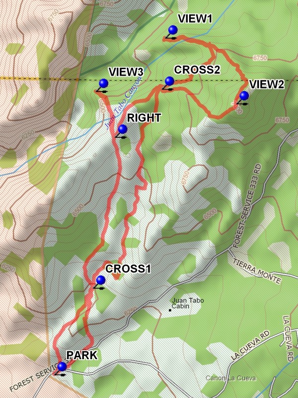
In Albuquerque go north on Tramway Blvd to Forest Hwy 333, the road to the La Luz trailhead. Follow 333 northeast for a short distance and PARK (0.0 mi) at the pay station on the right. A three dollar fee or Golden Age Pass is required to park here.
Actual Hike
Cross the road and go up the trail to the ridge. There are two points where your out and back paths will cross. After passing over the ridge follow the trail along the back side to CROSS1 (0.4 mi). Stay right at this intersection. A small narrow canyon is entered. The trail goes upward to the 1.4 mile point at CROSS2 (1.4 mi). Stay left. The trail circles around to the left, going out onto a prominence to VIEW1 (1.9 mi). From here there is a good view into Lower Juan Tabo canyon. Then return, going left at the Y and up the ridge to VIEW2 (2.4 mi). This is the highest point on the hike, with good views in all directions. This is also where the geocache “Alas, Poor Yorick” resides. The trail then drops down, curving to the right towards CROSS2. Continue straight ahead downward to the point RIGHT (3.0 mi). By going sharp right to VIEW3 (3.2 mi), there is another view into Lower Juan Tabo. Or skip it and continue down to CROSS1. Go straight and up over the ridge, proceeding down to the road. A short distance down the road is PARK.
Comments
This hike involves some steep hiking. The average grade for this hike is 12%.
WaypointsPARK: N35 12.152, W106 30.245
CROSS1: N35 12.422, W106 30.097
CROSS2: N35 13.043, W106 29.834
VIEW1: N35 13.203, W106 29.821
VIEW2: N35 12.998, W106 29.548
RIGHT: N35 12.894, W106 30.013
VIEW3: N35 13.037, W106 30.087
Hike GPS File Name: JuanTaboCanyonWayTrack_DBDB.gpx
Hike GPS File: Click link to download hike waytrack file
Text Author: Dick Brown
Map Author: Marilyn Warrant
Waypoints Author: Dick Brown
Track Author: Dick Brown
Maintainer: Not Assigned
Editor: Marilyn Warrant