Battleship Rock to McCauley Hot Springs Hike
In Jemez Mountains Region
Map File Source: NG Topo
 Hike Key: H10090
Last Updated: 12/05/2023 7:29pm
Last Updated By: Marilyn Fixer
Hike Class: C (Challenging)
Hike Distance: 4 mi
Minimum Elevation: 6780 ft
Elevation Change: 753 ft
Total Uphill: 930 ft
Total Downhill: 930 ft
Avg. Grade: 11 %
Route Type: InOut
On Trail: Yes
Paved or Gravel Roads: Yes
GPS Advised: No
Drive Distance Round Trip: 130 mi
Drive Time One-Way: 1:30
Hiking Seasons: Spring, Summer, and Fall
New Mexico Game Unit: 6A
Hike Status: Published
Highlights
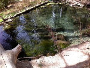
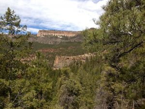
Walk among huge obsidian boulders and look down on Battleship Rock and river gorge. Bathe in upper or lower pools. Check out a waterfall at hike’s end.
CautionsHiking sticks and bathing suit recommended. Watch out for poison ivy around hot springs.
Trailhead Directions
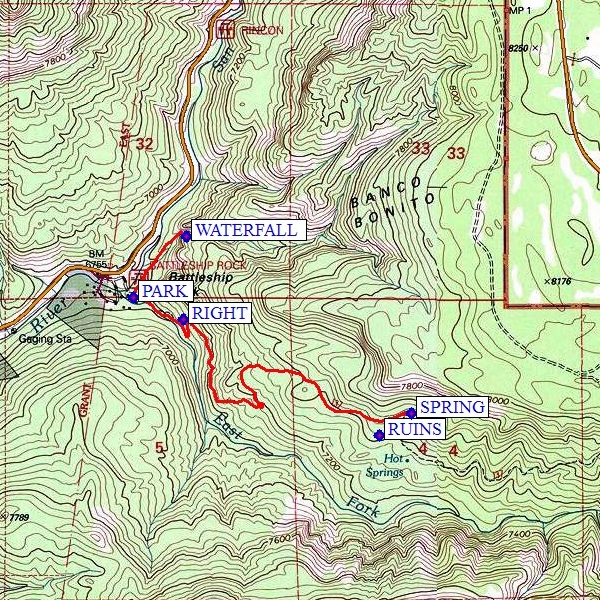
I-25 north to Bernalillo Exit 242, west on US 550 to San Ysidro, north on SR 4 past Jemez Springs to Battleship Rock Picnic Grounds. There is a small fee to park in this area. If possible drive across the small bridge and PARK (0.0 mi).
Actual Hike
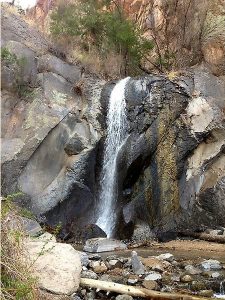
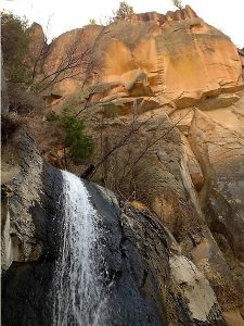
The hike begins on the far side of a picnic shelter at the back of the Battleship Rock day use area. Trail 137 follows the left side of the river for approximately 0.25 mile. At that point there is a sign for McCauley Hot Springs as the trail turns left and up the hill. From this point on you will begin to see amazing and amazingly huge obsidian boulders. These black glass wonders are the result of fast cooling of lava from the volcanic action in this area. After a few minutes of ascent an old trail veers slightly to the left, while the new trail turns sharply to the RIGHT (0.1 mi). Go to the right. Farther along the trail you will have excellent views of Battleship Rock and the gorge cut by the river. The trail continues its ascent then levels off somewhat as it passes through pine forest. Shortly before you reach the springs there are pueblo RUINS on the right–remains of walls and indentations in the soil. Look, but leave everything as you found it. The hot SPRING (1.5 mi) is on the hillside just below the trail. Several pools form as the waters bubble to the surface and flow down the hillside. A dip in either the upper or lower pools can be very refreshing. If you did not bring your bathing suit, you’ll have to go in your clothes. There’s a fine for bathing without. On returning to the Battleship Rock day use area, it’s possible to add a 20-minute hike extension to see falls WATERFALL at the north end of the picnic area.
Comments
Watch out for poison ivy around the hot springs area. Hike can be extended to Jemez Falls (another 2 miles beyond the hot springs) if you arrange a shuttle (see the Jemez Falls to Battleship Rock hike).
WaypointsPARK: N35 49.686, W106 38.634
RIGHT: N35 49.622, W106 38.452
RUINS: N35 49.280, W106 37.747
SPRING: N35 49.345, W106 37.635
WATERFALL: N35 49.865, W106 38.443
Hike GPS File Name: BattleshipRockToMcCauleyHotSpringsWaterfall_RS.gpx
Hike GPS File: Click link to download hike waytrack file
Text Author: Roger Holloway
Map Author: Marilyn Warrant
Waypoints Author: Marilyn Warrant
Track Author: Randy Simons
Maintainer: Nancy Carr
Editor: Marilyn Warrant