Rio Grande Nature Center North Hike
In Albuquerque Region
Map File Source: DeLorme
 Hike Key: H10079
Last Updated: 12/15/2020 12:00am
Last Updated By: Marilyn Warrant
Hike Class: B (Moderate)
Hike Distance: 6.9 mi
Minimum Elevation: 4965 ft
Elevation Change: 20 ft
Total Uphill: 20 ft
Total Downhill: 20 ft
Avg. Grade: 0 %
Route Type: InOut
On Trail: Yes
Paved or Gravel Roads: Yes
GPS Advised: No
Drive Distance Round Trip: 20 mi
Drive Time One-Way: 0:15
Hiking Seasons: Spring, Fall, and Winter
New Mexico Game Unit: 9
Hike Status: Published
Highlights
Walk along the Bosque.
CautionsNone.
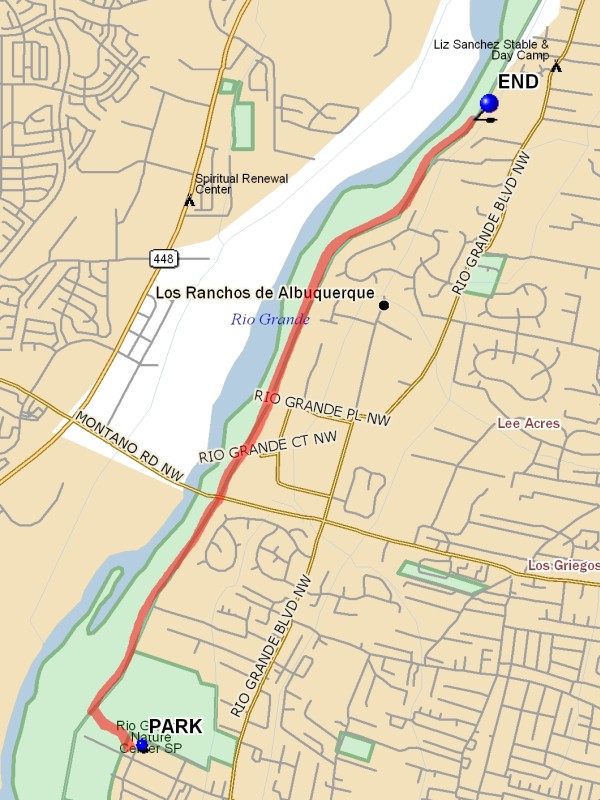
Trailhead Directions
In Albuquerque take Candelaria west to the end, go right to parking. There is a parking fee unless a city van is being used. Or park free on the last cross street before the end of Candelaria.
Actual Hike
Take the path past the Nature Center Building and across the bridge that crosses the irrigation ditch. Go north on the paved trail as far as desired, then turn around at END (3.45 mi) and come back.
Waypoints
PARK: N35 07.718, W106 40.849
END: N35 10.142, W106 39.279
Hike GPS File Name: RioGrandeNatureCenterNorthWayTrack_DBDB.gpx
Hike GPS File: Click link to download hike waytrack file
Text Author: Dick Brown
Map Author: Marilyn Warrant
Waypoints Author: Dick Brown
Track Author: Dick Brown
Maintainer: Joan Weissman
Editor: Marilyn Warrant