Kayser Mill Canyon Hike
In Manzano Mountains East Region
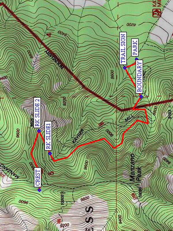
Map File Source: NG Topo
 Hike Key: H10077
Last Updated: 12/05/2023 9:37pm
Last Updated By: Marilyn Fixer
Hike Class: D (Difficult)
Hike Distance: 4.7 mi
Minimum Elevation: 8352 ft
Elevation Change: 1492 ft
Total Uphill: 1532 ft
Total Downhill: 1532 ft
Avg. Grade: 15 %
Route Type: InOut
On Trail: Yes
Paved or Gravel Roads: Yes
GPS Advised: No
Drive Distance Round Trip: 130 mi
Drive Time One-Way: 1:45
Hiking Seasons: Spring, Summer, and Fall
New Mexico Game Unit: 14
Hike Status: Published
Highlights
A strenuous hike in the Manzanos up to the Manzano Crest Trail.
CautionsSteep, so hiking poles recommended. Impacted by fires; burned logs across the trail as well as thorny New Mexico locust bushes.
Trailhead Directions
I-40 east to Tijeras exit 175. South on 337 (14) to its end (mile 0). West on SR 55 through Tajique and Torreon. When you get to the town of Manzano look for a “Y” fork and a sign “To Red Canyon C.G. and SR 131”. Take that right fork and go past Manzano State Park. About 3 more miles, at Red Canyon C.G. a road forks off to the right into the campground. Don’t take it. Go straight ahead on what is or becomes FR 422 past Ox Canyon Trail and 0.1 mi. past turnoff (to the left) onto FR 275. Turn right onto primitive road about 0.6 mi. (12 min.) to Kayser Mill Tr. 80 Trailhead and PARK (0.0 mi). The road is quite bad to begin with but it gets better. Or you can park anywhere short of the trailhead. You will pass Cottonwood Tr. 73 on the way.
Actual Hike
At FS map TRAIL SIGN (0.1 mi), the trail doubles back to the left, instead of going straight ahead like the road does. There is a nice aspen grove in the upper beginning of the canyon. You’ll go past the wilderness BOUNDARY (0.4 mi). You’ll see two rockslides in the canyon further along. These will be your intermediate objectives. You will think that you will be crossing over to the other side of the canyon soon, but you will be just going around another corner. This happens about three times until you actually do cross over to the other side. Even then, there is another arroyo to cross before getting to RK SLIDE1 (1.7 mi). Some people have done a lot of work to make the rockslides passable by filling in with smaller stones to make a rough pathway. The trail doubles back at RK SLIDE2 (1.9 mi), then continues on up to the Manzano CREST (2.3 mi) Trail.
Comments
The trail continues all the way to the Manzano Crest Trail, but we usually have hiked just past the first rockslide for lunch. The Manzano Crest Trail is only about one-half mile from the second rock slide. If people are not too tired, the views from there are certainly worth the extra walk. And then it’s all downhill going back.
WaypointsPARK: N34 35.472, W106 25.801
TRAIL SIGN: N34 35.550, W106 25.871
BOUNDARY: N34 35.442, W106 26.098
RK SLIDE1: N34 36.049, W106 26.559
RK SLIDE2: N34 36.122, W106 26.378
CREST: N34 36.121, W106 26.852
Hike GPS File Name: KayserMillCanyonWayTrack_FAFA.gpx
Hike GPS File: Click link to download hike waytrack file
Text Author: Roger Holloway
Map Author: Frances Arnold
Waypoints Author: Frances Arnold
Track Author: Frances Arnold
Maintainer: Marilyn Warrant
Editor: Randy Simons