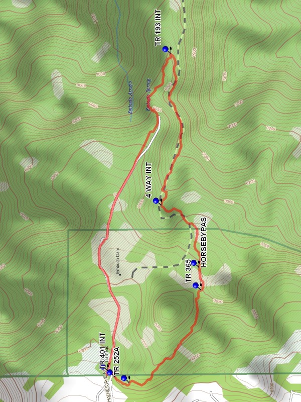
Embudo Loop Hike
In Sandia Mountain West Region
Map File Source: DeLorme
 Hike Key: H10076
Last Updated: 03/20/2023 2:27pm
Last Updated By: Marilyn Fixer
Hike Class: B (Moderate)
Hike Distance: 2.9 mi
Minimum Elevation: 6175 ft
Elevation Change: 575 ft
Total Uphill: 600 ft
Total Downhill: 600 ft
Avg. Grade: 9 %
Route Type: CCW Loop
On Trail: Yes
Paved or Gravel Roads: Yes
GPS Advised: No
Hiker Limit (NF/BLM/NP): 15 (Sandia Wilderness)
Drive Distance Round Trip: 20 mi
Drive Time One-Way: 0:15
Hiking Seasons: Spring, Fall, and Winter
New Mexico Game Unit: 8
Hike Status: Published
Highlights
Views of the city and the Sandias; wildflowers in season. Stream.
CautionsNone.
Trailhead Directions
In Albuquerque take Indian School east all the way to the very end and PARK (0.0 mi) in the lot down hill after the gate.
Actual Hike
Go east through the pass through and immediately go right (south). After about 200 feet there is a three pronged fork in the trail. Go straight. After another 200 feet a trail is crossed. Do not go up the steep pitch. Continue on the trail which goes south around the small peak and meets TR 365 (0.6 mi). Go east on Trail 365 which will pass over a foot bridge in about 100 feet. In about 0.1 mile reach the Embudo HORSEBYPAS (0.7 mi) sign. Bear right up hill and go to 4 WAY IN (1.0 mi). Continue uphill to TR 193 INT (1.6 mi). Try not to be confused by this sign post. Just turn left down hill and enter the wonders of the Embudo Canyon Narrows, fraught with a confusion of possible paths. The challenge is to come out the lower end. This section is usually wet interspersed with slick rocks. Use great care. From the beginning of this section to parking is about 0.6 mile.
Waypoints
PARK: N35 05.940, W106 28.797
TR 401 INT: N35 05.918, W106 28.819
TR 252A: N35 05.874, W106 28.840
TR 365: N35 05.654, W106 28.494
HORSEBYPAS: N35 05.661, W106 28.409
4 WAY INT: N35 05.776, W106 28.176
TR 193 INT: N35 05.747, W106 27.608
Hike GPS File Name: EmbudoLoopWayTrack_DBDB.gpx
Hike GPS File: Click link to download hike waytrack file
Text Author: Dick Brown
Map Author: Marilyn Warrant
Waypoints Author: Dick Brown
Track Author: Dick Brown
Maintainer: Not Assigned
Editor: Marilyn Warrant