Arroyo del Tajo Loop Hike
In Socorro Region
Map File Source: DeLorme
 Hike Key: H10072
Last Updated: 12/05/2023 6:36pm
Last Updated By: Marilyn Fixer
Hike Class: B (Moderate)
Hike Distance: 5.4 mi
Minimum Elevation: 4890 ft
Elevation Change: 300 ft
Total Uphill: 300 ft
Total Downhill: 300 ft
Avg. Grade: 3 %
Route Type: CCW Loop
On Trail: No
Paved or Gravel Roads: No
GPS Advised: Yes
Drive Distance Round Trip: 180 mi
Drive Time One-Way: 1:45
Hiking Seasons: Spring, Fall, and Winter
New Mexico Game Unit: 18
Hike Status: Published
Access Description: Quebradas Access
Highlights
Arroyo to a spectacular notch in a rugged ridge.
CautionsThe hike is off trail. Poles may be useful.
Trailhead Directions
From Albuquerque take I-25 south to the Lemitar exit. Go east for 0.5 mile on SR 408 E. Turn right onto SR-408 and go 3 miles to Escondido (Hidden) Lake. Turn left and go 1.6 miles (the road curves to the right after crossing the Rio Grande) to a sign “Quebradas Back Country Scenic Byway.” Turn left and go 10 mi. to PARK (0.0 mi). Park on the right before crossing the arroyo.
Actual Hike
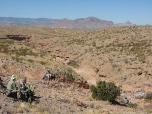
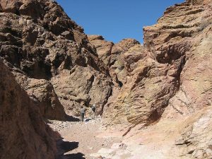
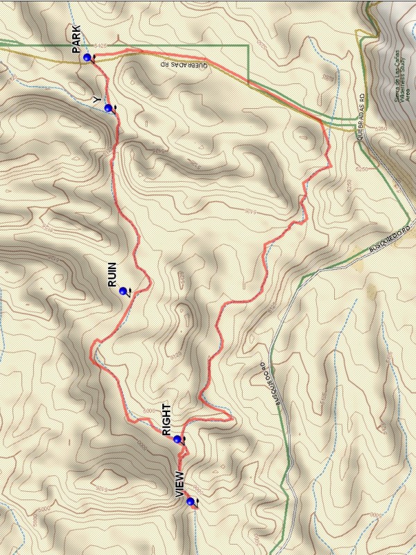
Go west from parking, working down into the arroyo. Reach a Y (0.2 mi) where and the main arroyo joins from the right. Continue east in the main arroyo which is broad and for the most part smooth. Near the notch there is a ranch RUIN (1.1 mi) off to the right out of the arroyo. At the 2 mile point is the entry to the notch. There is usually a pool of water filling the entry to the notch, which is impassable. To enter the notch go up the left side of the entry area and find a crevice which is a path into the notch. Once in the notch, it is impressive with high walls. At 2.2 miles the notch ends. Going on down the arroyo at this point is very difficult. Instead go up the left side of the end of the notch to VIEW (2.2 mi). The hike ends there. To continue on down the arroyo go up onto the ridge to the south, then work back down into the arroyo. Return back through the notch. Turn RIGHT (2.5 mi) into a side arroyo, passed previously at 1.9 miles. It appears to be small at this point, but becomes another significant arroyo in the area. Go right. A fence must be negotiated near the end of this segment of the hike. At 4.3 miles the road is reached. Go left (north) down the road and back to parking.
Comments
This hike is in the Presilla WSA, wilderness restrictions apply. This hike can be done as an in-out hike. In that case stay in the main arroyo at RIGHT. Be careful to go right at the Y, it is easy to miss going out.
WaypointsPARK: N34 02.997, W106 46.554
Y: N34 02.926, W106 46.760
RUIN: N34 02.877, W106 47.506
VIEW: N34 02.649, W106 48.362
RIGHT: N34 02.693, W106 48.110
Hike GPS File Name: ArroyodelTajoLoopWayTrack_DBDB.gpx
Hike GPS File: Click link to download hike waytrack file
Text Author: Dick Brown
Map Author: Marilyn Warrant
Waypoints Author: Dick Brown
Track Author: Dick Brown
Maintainer: Randy Simons
Editor: Marilyn Warrant