La Mesita Blanca Short Loop Hike
In Tohajillee Region
Map File Source: DeLorme
 Hike Key: H10058
Last Updated: 02/07/2022 12:00am
Last Updated By: Marilyn Fixer
Hike Class: B (Moderate)
Hike Distance: 4.4 mi
Minimum Elevation: 5833 ft
Elevation Change: 265 ft
Total Uphill: 481 ft
Total Downhill: 481 ft
Avg. Grade: 4 %
Route Type: CCW Loop
On Trail: No
Paved or Gravel Roads: No
GPS Advised: Yes
Drive Distance Round Trip: 90 mi
Drive Time One-Way: 1:00
Hiking Seasons: Spring, Fall, and Winter
New Mexico Game Unit: 9
Hike Status: Published
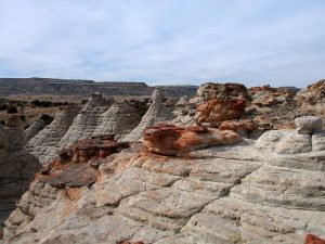
Attractions: Arroyos, Rock Formations, and Wildflowers
Highlights
Wander among outstanding red rock, tent rock and beehive formations.
CautionsMost of this hike is off trail.
Trailhead Directions
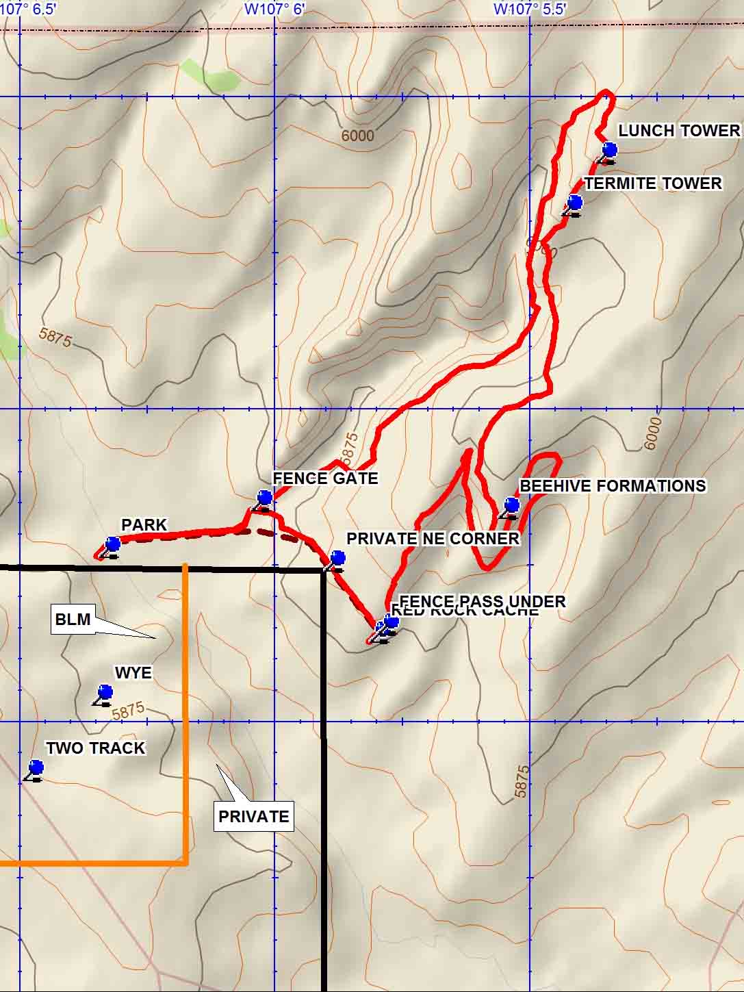
From Albuquerque take I-40 West to the Tohajillee exit. Go north to the village. Just before school area, turn right over a CATTLE GUARD with yellow sides (7.8 mi from I-40 interchange). Then an immediate left. Drive for approx. 8 mi., taking the obvious main road at any turns. At ‘T’ with another main road, go left for about 0.5 mi. and look for a TWO TRACK on the right that goes off towards a red rock area across the arroyo. Drive the two track, staying left at the WYE in the road and PARK (0.0 mi).
Actual Hike
Begin by heading east to the FENCE GATE (0.3 mi). Go through the gate, then southeast, going by the PRIVATE NE CORNER (0.5 mi). Just past the RED ROCK CACHE (0.7 mi), take a FENCE PASS UNDER (0.7 mi). Then go up to the shapes and spires to the northeast. This hike is just looking around for another interesting area to head to. The map just shows how it has been done in the past, but it need not be done the same way twice. Wander around up toward the mesa edge lined with white tent rocks. Go along the base of the BEEHIVE FORMATIONS (1.9 mi) curving around to the north bearing arroyo. Then go up to the mesa top and along the edge to the south, then curving to the west for great views of the red rock tops of the beehive formations. From there continue upward to the north to the TERMITE TOWER (2.5 mi) and on to the LUNCH TOWER (2.7 mi) for a lunch break. Continue back to PARK heading southwest along the east side of the arroyo.
Comments
The track shown goes on the east side of a deep arroyo over rough terrain. A “B” difficulty hike with great scenic value. Lots of volcanic plugs can be seen, most notable are Cabezon and Nuestra Senora. Enjoy!
WaypointsCATTLE GUARD: N35 05.820, W107 06.662
TWO TRACK: N35 11.907, W107 06.497
WYE: N35 12.027, W107 06.361
PARK: N35 12.263, W107 06.346
FENCE GATE: N35 12.339, W107 06.049
PRIVATE NE CORNER: N35 12.242, W107 05.905
FENCE PASS UNDER: N35 12.141, W107 05.800
RED ROCK CACHE: N35 12.128, W107 05.816
BEEHIVE FORMATIONS: N35 12.327, W107 05.564
TERMITE TOWER: N35 12.810, W10 05.441
LUNCH TOWER: N35 12.895, W107 05.373
Hike GPS File Name: LaMesitaBlancaShortLoopWayTrack_DBDB.gpx
Hike GPS File: Click link to download hike waytrack file
Text Author: Frances Arnold
Map Author: Dick Brown
Waypoints Author: Dick Brown
Track Author: Dick Brown
Maintainer: Carl Gervais
Editor: Marilyn Warrant