Mano Trail Loop Hike
In Sandia Mountain West Region
Map File Source: NG Topo
 Hike Key: H10055
Last Updated: 03/20/2023 2:32pm
Last Updated By: Marilyn Fixer
Hike Class: C (Challenging)
Hike Distance: 4.9 mi
Minimum Elevation: 6168 ft
Elevation Change: 886 ft
Total Uphill: 1216 ft
Total Downhill: 1216 ft
Avg. Grade: 12 %
Route Type: Loop
On Trail: Yes
Paved or Gravel Roads: Yes
GPS Advised: No
Hiker Limit (NF/BLM/NP): 15 (Sandia Wilderness)
Drive Distance Round Trip: 20 mi
Drive Time One-Way: 0:45
Hiking Seasons: Spring, Fall, and Winter
New Mexico Game Unit: 8
Hike Status: Published
Highlights
Good views to the west.
CautionsLots of scrambling over boulders, so footing can be difficult.
Trailhead Directions
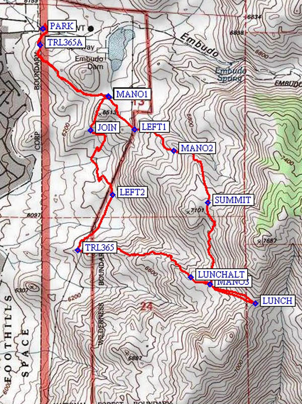
PARK (0.0 mi) in the lot at the East end of Indian School Rd.
Actual Hike
The Mano Trail gets it name from the hand-held rocks found here that were used by natives to grind corn and other food. The northern part of this trail gets little use and the southern part is heavily used. From the trailhead hike south and up TRL365A (0.1 mi) about 0.4 miles to a saddle with views of ABQ to the west and South Sandia Peak to the northeast. Walk southeast about 0.2 miles to a set of three poles supporting the power-line at MANO1 (0.6 mi). This is the start of the Mano Trail. Proceed east and up a steep grade. The trail turns to the south and then to the southeast to a critical waypoint (MANO2 (1.1 mi)). Here the trail appears to go south, but stay to the left and head northeast and eventually southeast up a steep hill to the SUMMIT (1.5 mi). Eventually the trail goes south for about 0.3 miles across a rather level plateau. The trail descends into a gentle canyon. On the far, south, side of the canyon you will run into a heavily used cross trail, part of the Mano Trail (MANO3 (2.0 mi)). If the weather is good, proceed to the east, up to the saddle for LUNCH (2.2 mi). Otherwise, have lunch out of the wind down lower, say at LUNCHALT (2.6 mi). After lunch descend the same trail going west, until you reach the power-line. This is the end of the Mano Trail. “U Mound” is to the southeast. From the power-line, hike down to the north on the well-traveled TRL365 (3.3 mi) that leads back to 365A and the trailhead at Indian School Rd.
Comments
ABQ., the Sunport, the Ladrones and Mt. Taylor in the distance. This hike is based on a similar hike of the same name in Mike Coltrin’s book: Sandia Mountain Hiking Guide, U of NM Press, 2005.
WaypointsPARK: N35 05.939, W106 28.823
TRL365A: N35 05.874, W106 28.839
MANO1: N35 05.660, W106 28.491
LEFT1: N35 05.525, W106 28.362
MANO2: N35 05.435, W106 28.166
SUMMIT: N35 05.223, W106 27.995
MANO3: N35 04.886, W106 27.983
LUNCH: N35 04.807, W106 27.758
LUNCHALT: N35 04.914, W106 28.081
TRL365: N35 05.027, W106 28.650
LEFT2: N35 05.254, W106 28.475
JOIN: N35 05.520, W106 28.584
Hike GPS File Name: ManoTrailLoopWayTrack_MWMW.gpx
Hike GPS File: Click link to download hike waytrack file
Text Author: John Holmes
Map Author: Marilyn Warrant
Waypoints Author: Marilyn Warrant
Track Author: Marilyn Warrant
Maintainer: Bill Gloyd
Editor: Marilyn Warrant