Otero Canyon To Tunnel Canyon Hike
In Cedro Peak Region
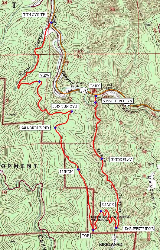
Map File Source: NG Topo
 Hike Key: H10054
Last Updated: 06/29/2021 12:00am
Last Updated By: Marilyn Fixer
Hike Class: C (Challenging)
Hike Distance: 6.2 mi
Minimum Elevation: 6593 ft
Elevation Change: 746 ft
Total Uphill: 866 ft
Total Downhill: 1108 ft
Avg. Grade: 6 %
Route Type: Oneway
On Trail: Yes
Paved or Gravel Roads: Yes
GPS Advised: No
Drive Distance Round Trip: 40 mi
Drive Time One-Way: 0:45
Hiking Seasons: Spring and Fall
New Mexico Game Unit: 14
Hike Status: Published
Highlights
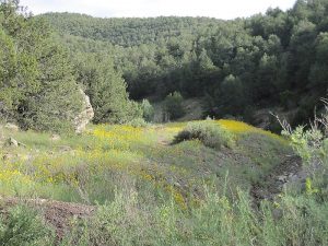
Japanese-like gardens, antique trees, old axe marks and early chain-saw cuts, an interesting granite wall and lovely flowers when in bloom.
CautionsIn winter, the trail may be covered with snow/ice. Therefore, hike trekking poles and/or boot traction devices are highly recommended.
Trailhead Directions
From Albuquerque take I-40 east. Take exit 175 south to Tijeras. From the traffic light in Tijeras go south on NM 337 (Old Highway 14) for 4 miles to Otero Canyon, [PARK] (0.0 mi) on the right.
Actual Hike
Start out by heading south on the 5056-OTERO CYN (0.1 mi) trail. GKIDS PLAY (0.8 mi) is where, on a future hike, the grandkids would enjoy playing on the rocks. Ponder the granite wall and areas which resemble Japanese gardens, as you amble up the Otero Canyon to the intersection of 5268-WESTRIDGE (1.7 mi).
At this point you are close to the Kirtland Air Force Base boundary and will turn right (west), up the ridge. It is an arduous climb up, but about half-way you can take a water break and SNACK (2.3 mi). Then it is another climb to the TOP (2.6 mi). Nearly a mile later, you will find a spot for LUNCH (3.3 mi), although other areas may suit your preference just as well.
After passing the turn-off on your left to 5411-BRDHS RID (3.9 mi) trail, you will head down a steep grade to the intersection with 5145-TUN CYN (4.2 mi). Turn left heading west and later north. You will come to VIEW (4.9 mi) revealing vistas to the north and east. The trail follows the ridge, in and out of side canyons, finally reaching TUN CYN TH (6.2 mi), where the shuttled van will be waiting.
Comments
The hike is a one-way hike, requiring shuttle arrangements. Suggestion: Drop the passengers off at the uphill trailhead (Otero Canyon) and shuttle the van back to the lower Tunnel trailhead. The additional driver and vehicle will drive the van driver back to the Otero Canyon trailhead, where the hikers will be waiting and ready to go.
Although this hike is advertised for Spring and Fall, with the proper clothing and footware the trail is good all year long. It is not a long drive from Albuquerque and it’s a fun place to bring friends and family. Hiking Otero Canyon may become addictive.
The Otero to Tunnel Canyon hike trails are shown close to the middle of the Manzanita Mountains Trail System map.
Hike data were determined using a Garmin GPSMap 62 and Garmin BaseCamp’s DEM for TOPO US 24K Southwest.
WaypointsPARK: N35 02.085, W106 22.453
5056-OTERO CYN: N35 02.085, W106 22.453
GKIDS PLAY: N35 01.474, W106 22.384
5268-WESTRIDGE: N35 00.803, W106 22.212
SNACK: N35 00.964, W106 22.396
TOP: N35 00.781, W106 22.483
LUNCH: N35 01.369, W106 22.662
5411-BRDHS RID: N35 01.774, W106 22.934
5145-TUN CYN: N35 01.931, W106 22.739
VIEW: N35 02.223, W106 23.118
TUN CYN TH: N35 02.796, W106 22.982
Hike GPS File Name: OteroTunCyn_BG.gpx
Hike GPS File: Click link to download hike waytrack file
Text Author: Bill Gloyd
Map Author: Bill Gloyd
Waypoints Author: Bill Gloyd
Track Author: Bill Gloyd
Maintainer: Bill Gloyd
Editor: Marilyn Warrant