Querencia To Dinosaur Dig Hike
In Ojito Region
Map File Source: DeLorme
 Hike Key: H10051
Last Updated: 12/15/2020 12:00am
Last Updated By: Marilyn Warrant
Hike Class: B (Moderate)
Hike Distance: 4 mi
Minimum Elevation: 5710 ft
Elevation Change: 200 ft
Total Uphill: 440 ft
Total Downhill: 440 ft
Avg. Grade: 5 %
Route Type: Loop
On Trail: No
Paved or Gravel Roads: No
GPS Advised: Yes
Drive Distance Round Trip: 90 mi
Drive Time One-Way: 1:15
Hiking Seasons: Spring, Fall, and Winter
New Mexico Game Unit: 9
Hike Status: Published
Access Description: Ojito Wilderness Area Access
Cautions
None.
Trailhead Directions
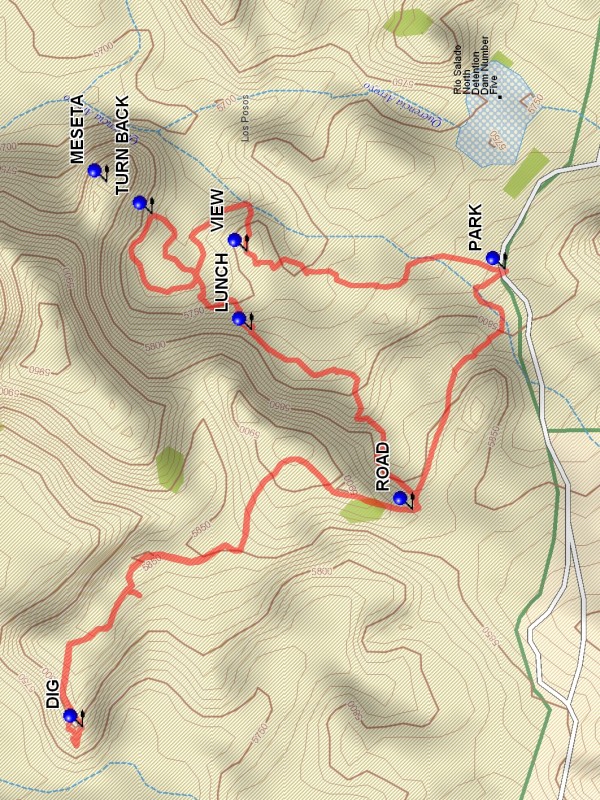
From Albuquerque go north on I-25 to the intersection of I-25 and US 550 (formerly SR 44) in Bernalillo go northwest on US 550 for 20.9 miles to Cabezon Road. This intersection is about 2 miles before San Ysidro. Turn left onto Cabezon Road. Almost immediately there is a Y in the road; go left. At 9.5 miles from the start of Cabezon Road, after going through a series of curves in the Querencia Arroyo area, the road starts uphill toward the Dinosaur Dig parking. There will be a pull off on the right at PARK (0.0 mi).
Actual Hike
Go north from parking for about 0.4 mile and ascend to the VIEW (0.4 mi) point. This affords a good view of the interesting terrain to the north, with a spidery web of eroded arroyo below feeding into Querencia Arroyo. Descend the east end of the view area and wander around the area to the TURN BACK (0.9 mi) point. From this point it is possible to ascend to the top of the MESETA, but the climb is steep and difficult. Then return through the area, staying against the mesa to the west as the route rises. This segment contains interesting rock, including areas with small polished stones. As the top is reached, a ROAD (1.7 mi) is encountered. Go right on the road. This road leads to the Dinosaur Dig. After visiting the dig return to the ROAD point and go down into the arroyo, but take the right branch instead of the left. This will eventually funnel into a narrow arroyo and back to parking.
Comments
This hike is in the Ojito Wilderness Area, wilderness restrictions apply.
WaypointsPARK: N35 29.796, W106 53.910
VIEW: N35 30.130, W106 53.882
TURN BACK: N35 30.253, W106 53.823
LUNCH: N35 30.124, W106 54.007
ROAD: N35 29.911, W106 54.270
DIG: N35 30.343, W106 54.637
Hike GPS File Name: QuerenciaToDinosaurDigWayTrack_DBDB.gpx
Hike GPS File: Click link to download hike waytrack file
Text Author: Dick Brown
Map Author: Marilyn Warrant
Waypoints Author: Dick Brown
Track Author: Dick Brown
Maintainer: Bill Gloyd
Editor: Marilyn Warrant