Ceja Pelon Hike
In Cuba Region
Map File Source: DeLorme
 Hike Key: H10027
Last Updated: 12/05/2023 8:40pm
Last Updated By: Marilyn Fixer
Hike Class: B (Moderate)
Hike Distance: 4.4 mi
Minimum Elevation: 6915 ft
Elevation Change: 315 ft
Total Uphill: 430 ft
Total Downhill: 430 ft
Avg. Grade: 5 %
Route Type: Loop
On Trail: No
Paved or Gravel Roads: No
GPS Advised: Yes
Drive Distance Round Trip: 200 mi
Drive Time One-Way: 2:00
Hiking Seasons: Summer and Fall
New Mexico Game Unit: 7
Hike Status: Published
Highlights
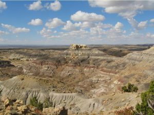
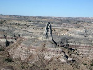
Interesting sandstone formations, extensive colorful badlands, largest collection of petrified wood in New Mexico.
CautionsOff-trail hike over rough terrain with steep pitches. Hiking poles recommended.
Trailhead Directions
From Albuquerque take I-25 north to Bernalillo. At Bernalillo take US 550 west to the intersection with SR 197 in Cuba. Turn left and drive 9 miles to the DIRT road at the bend in SR 197. Turn right onto the dirt road which immediately turns left and heads west. Drive 7.2 miles to LOVINO WOODS road on the right. Turn right and go 2.2 miles to a faint road on the LEFT. Turn left and drive 0.7 miles and PARK (0.0 mi) your vehicle at the well pad post. (see comment below re avoiding the road to PARK which is in poor condition).
Actual Hike
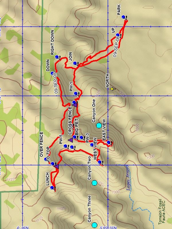
Start the hike by going northwest toward the low rise and UP (0.1 mi) onto it, Continue northwest to JOIN (0.5 mi). The hike will enter a sandy bottom arroyo which curves around to the west to a two track. Continue upward on the two track to Saddle One at about 0.8 miles. Petrified wood areas are encountered during this ascent. Drop down to a ledge area at the top of Canyon One. There are numerous petrified wood specimens in the area, some of them large. There is a good view of the area down this canyon. The hike continues up toward Saddle Two to a fence at CROSS FENCE (1.1 mi). At this point follow the fence to the south to the EAST VIEW (1.5 mi). This point affords views of the area and the black badlands below. There is much petrified wood on this “peninsula”. Retreat from the peninsula and back south to the WEST VIEW (1.8 mi) for great views of the badlands and formations. Then work back north along the edge of Canyon Two until the top of that canyon is reached. There are some very large specimens and good canyon views along this segment of the hike. Pass around the top end of the canyon and ascend over Saddle Three to the LUNCH (2.5 mi) spot at the edge of Canyon Three. Then go back to the mesa cliff to TO TOP (2.7 mi) where there is a steep traverse northeastward to the top of the mesa. Go along the mesa edge for views to the south and sandstone formations. At the DOWN (3.5 mi) point descend to a white ridge and continue east to RIGHT DOWN (3.6 mi) where there is a way to descend to the floor below. Once down bear right and follow the stream bed which will take you back to JOIN. At this point follow the stream bed back to PARK.
Comments
The road to the PARK point is in poor condition. If in doubt, park at PARK FAR. This will add 1.2 miles to the hike distance. The waypoints Pw etc are locations of a few of the petrified wood specimens, and are not all shown on the map. The hike can be shortened by returning the way you came rather than going to the top of the mesa, and bypassing the viewpoints.
WaypointsDIRT: N35 57.382, W107 05.520
LEFT: N35 59.478, W107 13.716
LOVINO-WOODS: N 35 57.423, W 107 13.182
PARK FAR: N35 59.458, W107 13.858
PARK: N35 59.391, W107 14.455
UP: N35 59.425, W107 14.585
JOIN: N35 59.676, W107 14.790
PW-1: N35 59.671, W107 15.009
PW-2: N35 59.681, W107 15.074
PW-2A: N35 59.701, W107 15.236
CROSS FENCE: N35 59.678, W107 15.323
BIG PET: N35 59.637, W107 15.327
EAST VIEW: N35 59.479, W107 15.362
PW-3: N35 59.576, W107 15.380
WEST VIEW: N35 59.530, W107 15.505
PW-4 (CACHE): N35 59.694, W107 15.397
PW-5: N35 59.731, W107 15.389
LUNCH: N35 59.810, W107 15.689
Hike GPS File Name: CejaPelonWayTrack_DBDB.gpx
Hike GPS File: Click link to download hike waytrack file
Text Author: Dick Brown
Map Author: Dick Brown
Waypoints Author: Dick Brown
Track Author: Dick Brown
Maintainer: Randy Simons
Editor: Randy Simons