Otero Canyon East Loop Hike
In Cedro Peak Region
Map File Source: NG Topo
 Hike Key: H10024
Last Updated: 06/29/2021 12:00am
Last Updated By: Marilyn Fixer
Hike Class: C (Challenging)
Hike Distance: 5.3 mi
Minimum Elevation: 6797 ft
Elevation Change: 557 ft
Total Uphill: 993 ft
Total Downhill: 993 ft
Avg. Grade: 6 %
Route Type: CW Loop
On Trail: Yes
Paved or Gravel Roads: Yes
GPS Advised: No
Drive Distance Round Trip: 40 mi
Drive Time One-Way: 0:45
Hiking Seasons: Spring, Summer, and Fall
New Mexico Game Unit: 14
Hike Status: Published
Highlights
A well-marked forested trail along the ridges of the Manzanita Mountain foothills close to Albuquerque.
CautionsIn winter, the trail may be covered with snow/ice. Therefore, hike trekking poles and/or boot traction devices are highly recommended.
Trailhead Directions
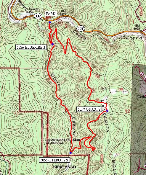
From Albuquerque take I-40 east. Take exit 175 south to Tijeras. From the traffic light in Tijeras go south on NM 337 (Old Highway 14) for 4 miles to Otero Canyon, [PARK] (0.0 mi) on the right.
Actual Hike
The Otero Canyon trail (#5056) goes south on an old road bed for a short distance, then drops off the paved road, crossing a small stream bed. It proceeds up the canyon to where 5236-BLUERIBBN (0.3 mi) comes in from the far left, around your left shoulder. Take this trail around to the north (not intuitive) for a half a mile before heading back southeast to 5057-GNASTY (2.2 mi). At this point the trail turns southwest and then west down into a ravine to 5056-OTERO CYN (3.2 mi). The return portion is a pleasant hike down the canyon to PARK (5.3 mi).
Comments
The Otero Canyon East Loop hike trails are shown in the middle left part of the Manzanita Mountains Trail System map.
Hike data were determined using a Garmin GPSMap 62 and Garmin BaseCamp’s DEM for TOPO US 24K Southwest.
WaypointsPARK: N35 02.079, W106 22.455
5236-BLUERIBBN: N35 01.862, W106 22.425
5057-GNASTY: N35 01.198, W106 21.763
5056-OTEROCYN: N35 00.779, W106 22.204
Hike GPS File Name: Otero Cyn East Loop_BG.gpx
Hike GPS File: Click link to download hike waytrack file
Text Author: Bill Gloyd
Map Author: Bill Gloyd
Waypoints Author: Bill Gloyd
Track Author: Bill Gloyd
Maintainer: Bill Gloyd
Editor: Marilyn Warrant