Aspen Vista Hike
In Sangre De Cristos Region
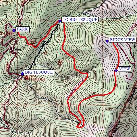
Map File Source: NG Topo
 Hike Key: H10006
Last Updated: 12/15/2020 12:00am
Last Updated By: Marilyn Warrant
Hike Class: C (Challenging)
Hike Distance: 8 mi
Minimum Elevation: 9980 ft
Elevation Change: 1400 ft
Total Uphill: 1465 ft
Total Downhill: 1465 ft
Avg. Grade: 10 %
Route Type: InOut
On Trail: Yes
Paved or Gravel Roads: Yes
GPS Advised: No
Drive Distance Round Trip: 140 mi
Drive Time One-Way: 1:30
Hiking Seasons: Summer and Fall
New Mexico Game Unit: 44
Hike Status: Published
Highlights
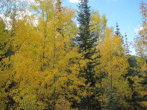
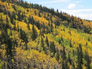
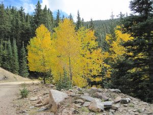
Climb through aspen forests to enjoy spectacular fall foliage and expansive views.
CautionsHigh elevation hike.
Trailhead Directions
Take I-25 north to Santa Fe. Take the Old Pecos Trail exit 284 and follow to Paseo de Peralta. Turn right and follow to Washington Avenue, just before the pink Masonic Temple. Turn north on Washington, then east on Artist Road, which becomes Hyde Park Rd. Continue past the Big Tesuque campground to Aspen Vista PARK (0.0 mi).
Actual Hike
Park at Aspen Vista Picnic Area. The hike follows a road that accesses Tesuque Peak. It begins at about 10,000′ elevation and ascends steadily through beautiful aspen forests. We saw lovely wildflowers all along the way. There are excellent views of the Santa Fe area at several openings in the forest. At about 2.4 miles and 11,000 feet the road makes a sharp switchback and begins traversing the mountainside in the opposite direction. The forest also changes to mostly evergreen. Continuing another mile on this gradually ascending “switchback” you reach about 11,250 feet and a wonderful VIEW (3.6 mi). A lovely large bristlecone pine stands beside the road. It’s a good lunch spot. Continue to the RIDGE VIEW (4.0 mi) for a more expansive view, then return to parking. If you are entertaining continuing to the top it is another 2 miles one way, making it a 12 mile E rated hike.
An option on the return trip is for the driver to hike down to the Aspen Vista trailhead, pick up the van, and meet the hikers at the BIG TESUQUE parking lot. The hikers take the trail starting at TO BIG TESUQUE (7.2 mi) downhill through a forest to the BIG TESUQUE trailhead. This option is about 0.5 mi longer, but worth it.
Comments
The aspens should be in spectacular color in the fall.
WaypointsAspen Vista
PARK: N35 46.632, W105 48.664
VIEW: N35 46.225, W105 47.383
RIDGE VIEW: N35 46.525, W105 47.496
Option
TO BIG TESUQUE: N35 46.730, W105 48.088
BIG TESUQUE: N35 46.192, W105 48.559
Hike GPS File Name: AspenVistaModOption_MW.gpx
Hike GPS File: Click link to download hike waytrack file
Text Author: Roger Holloway
Map Author: Marilyn Warrant
Waypoints Author: Dick Brown
Track Author: Dick Brown
Maintainer: Dawn McIntyre
Editor: Howard Carr