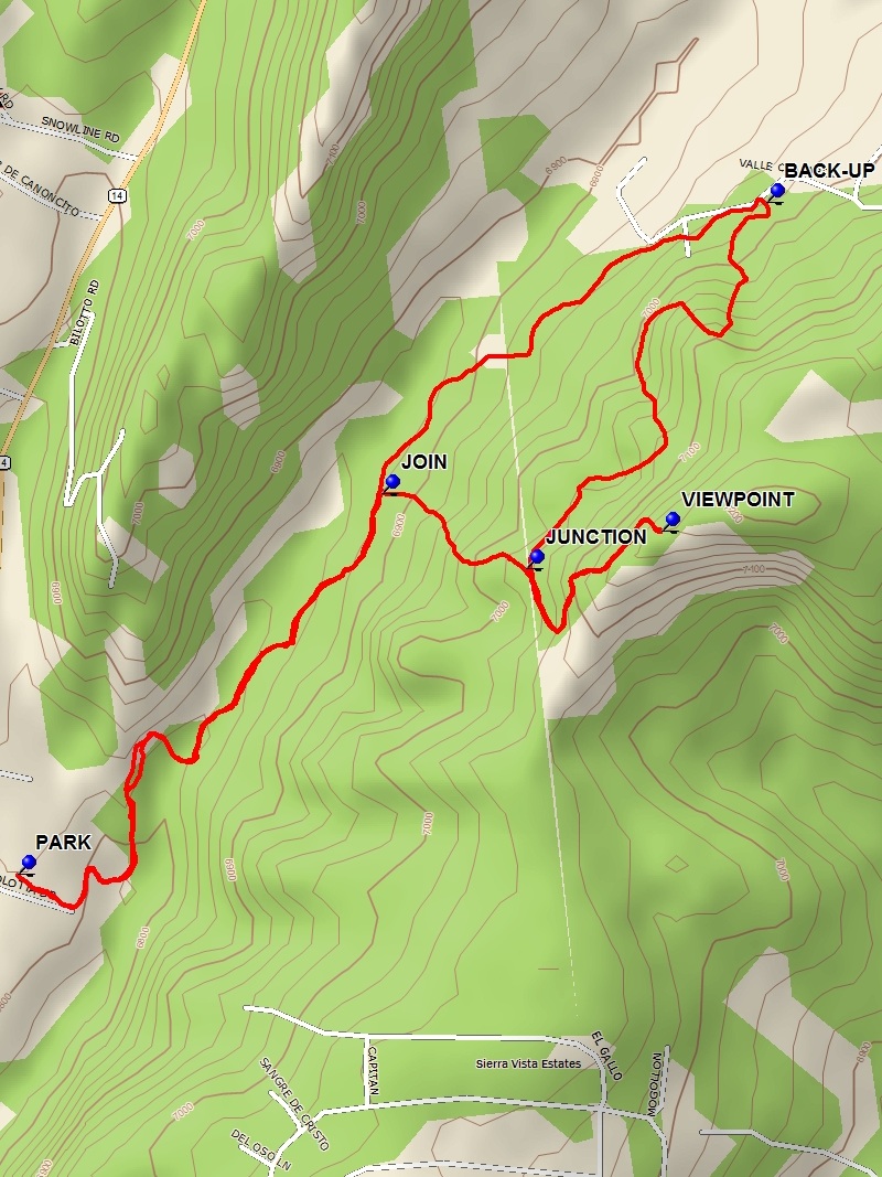
Milne – Gutierrez West Open Space Hike
In Golden Region
Map File Source: DeLorme
 Hike Key: H10632
Last Updated: 07/15/2022 9:34am
Last Updated By: Marilyn Fixer
Hike Class: B (Moderate)
Hike Distance: 3.4 mi
Minimum Elevation: 6780 ft
Elevation Change: 410 ft
Total Uphill: 555 ft
Total Downhill: 555 ft
Avg. Grade: 9 %
Route Type: Lollypop
On Trail: Yes
Paved or Gravel Roads: Yes
GPS Advised: Yes
Drive Distance Round Trip: 35 mi
Drive Time One-Way: 0:15
Hiking Seasons: Spring, Summer, Fall, and Winter
New Mexico Game Unit: 8
Hike Status: Inactive
Highlights
An interesting hike through pinion/juniper forest and rock formations.
CautionsHiking poles useful for steep sections.
Trailhead Directions
From Albuquerque, take I-40 east to the Sandia Crest exit and go north on SR-14 to a parking area on the right just south of the Post Office and park at PARK.
Actual Hike
From PARK go east through the fence opening and follow the trail down into the arroyo. Go right up the arroyo and exit to the right side of the arroyo. Proceed past JOIN (0.7 mi) to the point BACK-UP (1.3 mi) and turn back south and take the trail traverse to JUNCTION (2.0 mi). Go left on the intersecting trail and go to the VIEWPOINT (2.2 mi). After enjoying the view and perhaps some lunch start your return. At JUNCTION (2.5 mi) go straight and down a rather steep trail to the JOIN (2.7 mi) point. Turn left and retrace the way you came to PARK (3.4 mi).
Comments
See the Open Space map.
WaypointsBACK-UP: N35 08.378, W106 21.090
JOIN: N35 08.112, W106 21.519
JUNCTION: N35 08.044, W106 21.358
PARK: N35 07.765, W106 21.925
VIEWPOINT: N35 08.078, W106 21.207
Hike GPS File Name: Milne-GutierrezWestOpenSpaceWayTrackRev_DBDB.gpx
Hike GPS File: Click link to download hike waytrack file
Text Author: Dick Brown
Map Author: Dick Brown
Waypoints Author: Dick Brown
Track Author: Dick Brown
Maintainer: Cindy McConnell
Editor: Howard Carr