Elena Gallegos to Tram Loop Hike
In Sandia Mountain West Region
Map File Source: NG Topo
 Hike Key: H10588
Last Updated: 03/03/2025 7:36pm
Last Updated By: Marilyn Fixer
Hike Class:
Hike Distance: 5.9 mi
Minimum Elevation: 6401 ft
Elevation Change: 305 ft
Total Uphill: 874 ft
Total Downhill: 874 ft
Avg. Grade: 6 %
Route Type: CCW Loop
On Trail: Yes
Paved or Gravel Roads: Yes
GPS Advised: No
Drive Distance Round Trip: 26 mi
Drive Time One-Way: 0:15
Hiking Seasons: Spring, Fall, and Winter
New Mexico Game Unit: 8
Hike Status:
Highlights
Good views of Mount Taylor, Cabezon Peak, the Ladrone Mtns., Domingo Baca Canyon, and near views of the city.
CautionsSome steep areas become slick with winter snows so trekking poles are recommended. Avoid scheduling during hot summer months. Share the trail with mountain bikes on the #365 Trail portion of hike.
Trailhead Directions
Drive Tramway Blvd north of Academy Rd and watch for Elena Gallegos Picnic Area sign on the east at Simms Park Rd. Turn east here and drive for 1.7 miles to the entrance and pay station. This is a fee area ($1 weekdays, $2 weekends), so pay the attendant or use the provided envelope to pay and keep your portion of the envelope to display on your dashboard. Turn right or south and drive the one-way road to the far northeast corner (PARK EAST) which is also parking for the Pino Trail #140.
Actual Hike
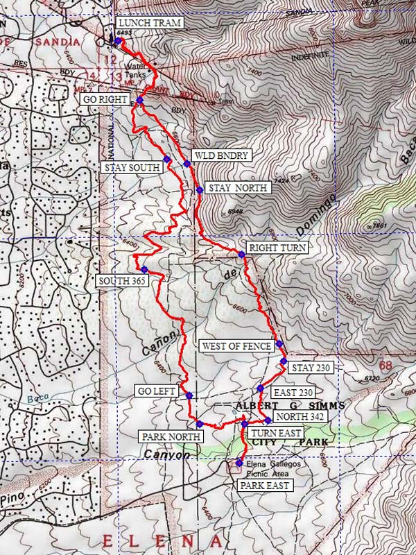
From PARK EAST (0.0 mi) go east to the #140 trailhead and make an immediate left or north turn at the small Nature Trail (Hikers Only) sign. Continue hiking north to a junction at TURN EAST (0.2 mi) and go east to NORTH 342 (0.3 mi). Continue hiking northerly to EAST 230 (0.45 mi) and turn northeasterly to STAY 230 (0.68 mi). Continue north to a fence line at WEST OF FENCE (0.75 mi) and continue north on the trail west of the fence and outside of the Sandia Mountain Wilderness Area. Continue hiking northerly and on the ridge top (max elevation of hike at 6706 ft.), make a RIGHT TURN (1.25 mi), and take the little jog right then left passing thru a fence and entering the Wilderness Area. Hike northwesterly descending the ridge to STAY NORTH (1.7 mi) ignoring the several paths leading off to the west. At WLD BNDRY (1.85 mi) you will leave the Wilderness Area and continue northwesterly to a junction with the #365 Trail at GO RIGHT (2.25 mi). Continue northerly on the #365 Trail climbing a hill and passing by some large water tanks then descend the hill to the lower tram terminal at LUNCH TRAM (2.65 mi). Restrooms, drinking fountain, and bench seating are found in the lower level. This is a good place for lunch.
After lunch, hike back up the hill passing the water tanks and descend to GO RIGHT (3.1 mi) and hike the #365 Trail south to STAY SOUTH (3.5 mi). Continue southerly thru the wide sweeping turns designed for mountain bikes. Another junction is reached at SOUTH 365 (4.45 mi) where you continue southeasterly on the #365 Trail to a junction at GO LEFT (5.25 mi). Follow this toward an old orange wind sock (for hang glider landings) at a paved parking area PARK NORTH (5.45 mi). Near the pit toilet here, turn east crossing the wooden bridge on the Cottonwood Springs/Nature Trail. Follow this east noting the several interesting info signs along the way to a wildlife blind viewing a pond. Turn south here on the well-used Nature Trail and follow it back to your vehicle at PARK EAST (5.9 mi).
Comments
This hiking trail weaves through many interesting boulder and rock formations. This is a great foothills hike especially through a fresh winter snow.
The Sandia Ranger District has set a 25-hiker limit for this area.
WaypointsPARK-EAST: N35 09.798, W106 28.203
TURN EAST: N35 09.950, W106 28.177
NORTH 342: N35 09.963, W106 28.064
EAST 230: N35 10.091, W106 28.102
STAY 230: N35 10.197, W106 27.991
WEST OF FENCE: N35 10.262, W106 28.012
RIGHT TURN: N35 10.611, W106 28.189
STAY NORTH: N35 10.866, W106 28.390
WLD BNDRY: N35 10.968, W106 28.450
GO RIGHT: N35 11.217, W106 28.675
LUNCH TRAM: N35 11.449, W106 28.780
STAY SOUTH: N35 10.984, W106 28.547
SOUTH 365: N35 10.553, W106 28.655
GO LEFT: N35 10.062, W106 28.442
PARK NORTH: N35 09.949, W106 28.390
Hike GPS File Name: ElenaGallegosToTramLoopHike_SMSM.gpx
Hike GPS File: Click link to download hike waytrack file
Text Author: Sandy McAvoy
Map Author: Ken Smith
Waypoints Author: Sandy McAvoy
Track Author: Sandy McAvoy
Maintainer: Not Assigned
Editor: Marilyn Warrant