Arroyo Piedra Lumbre East Hike
In Cabezon Region
Map File Source: DeLorme
 Hike Key: H10525
Last Updated: 03/11/2021 12:00am
Last Updated By: Marilyn Fixer
Hike Class: B (Moderate)
Hike Distance: 4.3 mi
Minimum Elevation: 6250 ft
Elevation Change: 100 ft
Total Uphill: 420 ft
Total Downhill: 420 ft
Avg. Grade: 3 %
Route Type: CW Loop
On Trail: No
Paved or Gravel Roads: No
GPS Advised: Yes
Drive Distance Round Trip: 150 mi
Drive Time One-Way: 1:30
Hiking Seasons: Spring, Summer, and Fall
New Mexico Game Unit: 9
Hike Status: Published
Highlights
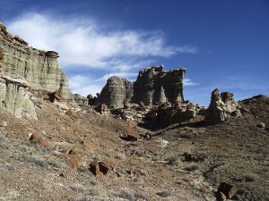
Lots of interesting rock formations and cliffs on this wandering hike.
CautionsThe hike is off trail. Poles may be useful.
Trailhead Directions
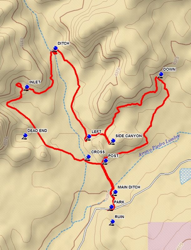
From Albuquerque take I-25 north to Bernalillo. Take US 550 to San Ysidro. Drive west 18 mi. past intersection of SR 4 and US 550 to San Luis Rd.. Turn left and drive 8.5 miles to Torreon Road just after a cattle guard, where the road turns to dirt. Turn right onto paved Torreon Rd (SR 197) and drive 3.6 miles to the top of the rise. TURN LEFT onto a dirt road. Go 4 miles to PARK below a low hill with a stone ruin on top.
Actual Hike
From PARK cross the road and go to a low man made ridge which will lead to the MAIN DITCH (0.1 mi). Descend into the ditch and continue on the animal trail on the north side, which will take you out of the ditch. Head north until you reach a POST (0.3 mi). Bear north and cross a side ditch at CROSS (0.4 mi). Continue northwest toward the cliffs ahead. Explore the DEAD END canyon if you wish. Continue northwest along the cliff. There are many interesting formations in this area. You will curve around, heading east. At the INLET (1.1 mi) go in and visit it’s formations many of which are in an inaccessible area to the north. Then return and continue on, curving to the north. Here there is a second DITCH (1.7 mi) to find your way through. Go south, enjoying the formations on the cliff to your left. You will pass a large side canyon on the left. Continue to a second side canyon at LEFT (2.4 mi). Turn east into this canyon and visit the SIDE CANYON (2.6 mi) there. You then encounter a dead end, but there is a way up and out. The next segment of the hike has a nice variety of formations. Proceed to DOWN (3.2 mi) and go right, finding your way to the bottom. Now head southwest, enjoying the many formations on the canyon side. When you reach the POST retrace your way to parking.
Comments
After returning to parking, go up on the low ridge to the south and visit the RUIN The use of a GPS is advised.
WaypointsDEAD END: N35 43.100, W107 10.772
RUIN: N35 42.674, W107 10.240
TURN LEFT: N35 42.440, W107 06.682
PARK: N35 42.746, W107 10.247
MAIN DITCH: N35 42.820, W107 10.223
POST: N35 42.976, W107 10.282
CROSS: N35 42.994, W107 10.387
INLET: N35 43.339, W107 10.761
DITCH: N35 43.531, W107 10.588
LEFT: N35 43.094, W107 10.384
SIDE CANYON: N35 43.074, W107 10.237
DOWN: N35 43.403, W107 09.945
Hike GPS File Name: ArroyoPiedraLumbreWayTrack_DBDB.gpx
Hike GPS File: Click link to download hike waytrack file
Text Author: Dick Brown
Map Author: Dick Brown
Waypoints Author: Dick Brown
Track Author: Dick Brown
Maintainer: John Cooper
Editor: Howard Carr