Santa Barbara CG to Santa Barbara Middle Fork Hike
In Pecos North Region
Map File Source: Garmin BaseCamp
 Hike Key: H10451
Last Updated: 06/30/2021 12:00am
Last Updated By: Marilyn Fixer
Hike Class: C (Challenging)
Hike Distance: 5.7 mi
Minimum Elevation: 8874 ft
Elevation Change: 572 ft
Total Uphill: 982 ft
Total Downhill: 982 ft
Avg. Grade: 5 %
Route Type: InOut
On Trail: Yes
Paved or Gravel Roads: Yes
GPS Advised: No
Hiker Limit (NF/BLM/NP): 15 (Pecos Wilderness)
Drive Distance Round Trip: 260 mi
Drive Time One-Way: 2:30
Hiking Seasons: Summer
New Mexico Game Unit: 44
Hike Status: Published
Cautions
None.
Trailhead Directions
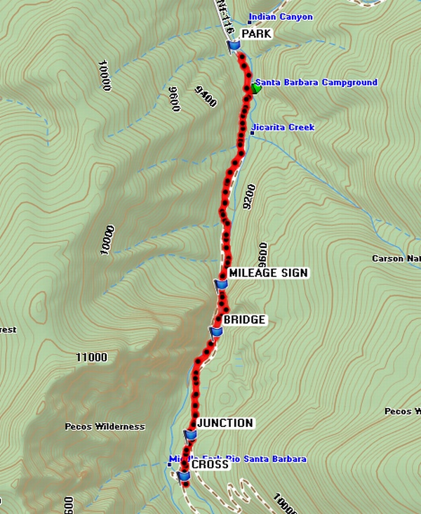
Drive north on I-25 and take the Santa Fe bypass to Espanola; continue toward Taos on Hwy 285. Turn east at 75 TO DIXON and go to Penasco. When the road makes a sharp left turn, go straight at TO 73 SB CG. Go about 1 mile and look for a brown state park sign on the right, which identifies a left turn at TO NF 116 (estimated location). The locals sometimes remove the sign. The road is paved for several miles and then turns into a forest gravel road. The scenery here is of a beautiful valley community and a view of Jicarilla Peak straight ahead at one point. Continue on the gravel road and you will reach the Santa Barbara Campground where there is a parking lot on the left prior to entering the campground. Continue into the campground and take the loop to the right. Drive to the back of the loop. Let all of the hikers out here. The driver needs to return the van to the parking lot to PARK (0.0 mi) at the entrance and walk back to the hiking group.
When returning from the hike, everyone can walk back to the van. Drive back to Albuquerque via the town of Truchas. Leave the campground and retrace the drive back to Penasco and head west on Hwy 76. After one or two miles, turn left at 76 TO TRUCHAS. Continue south and turn right in Truchas at TO CHIMAYO. Turn left at the Ortega Weavers. If desired, turn left in several blocks and visit the SANTUARIO. If you’re hungry, continue past the Santuario about 1/2 mile and turn into the Rancho de Chimayo RESTAURANT. After visiting the restaurant, continue on the highway southeast, take a right at TURN ON 503, and continue back to Hwy 285 and I-25 to Albuquerque. By taking a different road back to Albuquerque, you get to see a lot of different scenery and many small northern NM towns. This trip should leave early and return about 6pm.
Actual Hike
The trailhead is directly across from the parking lot, but DO NOT take this trail. After the driver parks the van and returns to the hiking group, find the trail at the end of the loop slightly southwest through a fence gate. The hike meanders next to the river and away from it passing through lush meadows. At one point when you are hiking down an incline, there is a good view of Chimayosos Peak on the top of the Santa Barbara Divide. The trail crosses a wooden BRIDGE (1.8 mi) over the Santa Barbara River. The trail splits at a JUNCTION (2.5 mi), take the right fork. (The left fork continues up the East and Middle Forks of the Santa Barbara River.) Immediately after the JUNCTION, the West Fork trail goes down hill and crosses the Santa Barbara River below the junction of the West Fork and the Middle/East Fork. CROSS (2.9 mi) the bridge and find a place for lunch. Return to the van by the same trail. Follow the directions back to Albuquerque via the other route to enjoy a different view on the way home.
Comments
If you continue on this trail it opens up into a large long meadow and then climbs the mountain to the west of Chimayosos Peak to the top of the Santa Barbara Divide and the Skyline Trail.
This hike is in the northern part of the Sangre de Cristos, in Carson National Forest.
Waypoints75 TO DIXON: N36 12.691, W105 54.645
73 TO SB CG: N36 10.174, W105 41.195
TO NF 116: N36 09.095, W105 40.364
PARK: N36 05.326, W105 36.630
MILEAGE SIGN: N36 04.173, W105 36.706
BRIDGE: N36 03.945, W105 36.736
JUNCTION: N36 03.447, W105 36.891
CROSS: N36 03.248, W105 36.932
76 TO TRUCHAS: N36 11.035 W105 42.351
TO CHIMAYO: N36 02.650 W105 48.764
SANTUARIO: N36 00.064 W105 55.749
RESTAURANT: N35 59.946 W105 55.798
TURN ON 503: N35 57.252 W105 56.301
Hike GPS File Name: SantaBarbaraCGtoSantaBarbaraMiddleForkWayTrack_RC.gpx
Hike GPS File: Click link to download hike waytrack file
Text Author: Rodger Carlson
Map Author: Marilyn Warrant
Waypoints Author: Rodger Carlson
Track Author: Rodger Carlson
Maintainer: Bill Gloyd
Editor: Marilyn Warrant