Challenge Loop Hike
In Sandia Mountain East Region
Map File Source: DeLorme
 Hike Key: H10438
Last Updated: 12/15/2020 12:00am
Last Updated By: Marilyn Warrant
Hike Class: C (Challenging)
Hike Distance: 6.3 mi
Minimum Elevation: 8613 ft
Elevation Change: 1390 ft
Total Uphill: 1450 ft
Total Downhill: 1450 ft
Avg. Grade: 10 %
Route Type: CCW Loop
On Trail: Yes
Paved or Gravel Roads: Yes
GPS Advised: Yes
Drive Distance Round Trip: 56 mi
Drive Time One-Way: 0:45
Hiking Seasons: Summer and Fall
New Mexico Game Unit: 8
Hike Status: Published
Highlights
Wildflowers, aspen groves, overlooks.
CautionsNone.
Trailhead Directions
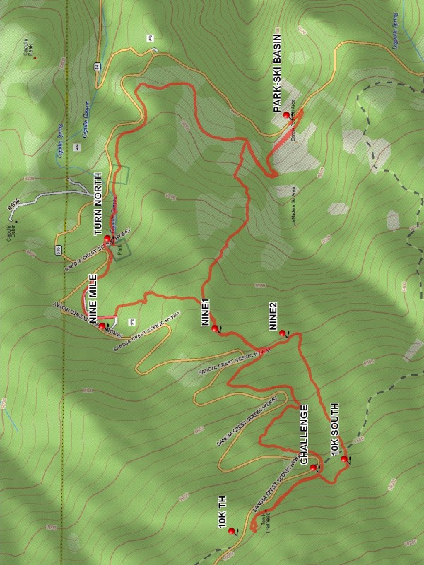
From Albuquerque take 1-40 east to Tijeras exit 175, then go north on SR 14 to SR 536. Go east up the mountain to the Sandia Ski Area, and park along the road at PARK-SKI BASIN.
Actual Hike
From parking, walk across the ski basin parking lot to the north side. Go up the road west until the Challenge Trail (an old logging road). Continue up the Challenge Trail and TURN NORTH (1.6 mi) to reach the NINE MILE (1.9 mi) picnic ground parking area. Walk on an old road until you reach NINE1 (2.4 mi). Then continue up past CHALLENGE (3.6 mi) to the 10K TH (3.9 mi) parking lot and have lunch. On the return take the 10K South Trail to CHALLENGE (4.2 mi). Continue on 10K South, then turn east at the 10K SOUTH (4.3 mi) waypoint. Follow to NINE2 (4.9 mi) then to NINE1 (5.1 mi) again. When you come to a fork (soon after the NINE1 waypoint), turn right and follow the trail back to the ski basin trail. Then turn right (south) to return to the ski basin parking lot.
Waypoints
PARK-SKI BASIN: N35 12.431, W106 24.744
TURN NORTH: N35 12.921, W106 25.158
NINE MILE: N35 12.935, W106 25.452
NINE1: N35 12.627, W106 25.460
CHALLENGE: N35 12.357, W106 25.927
10K TH: N35 12.581, W106 26.140
10K SOUTH: N35 12.272, W106 25.898
NINE2: N35 12.442, W106 25.477
Hike GPS File Name: ChallengeLoopWayTrack_DVDV.gpx
Hike GPS File: Click link to download hike waytrack file
Text Author: Dennis Vick
Map Author: Marilyn Warrant
Waypoints Author: Dennis Vick
Track Author: Dennis Vick
Maintainer: Not Assigned
Editor: Howard Carr