Quebradas Curved Cliff Hike
In Socorro Region
Map File Source: DeLorme
 Hike Key: H10415
Last Updated: 12/05/2023 9:52pm
Last Updated By: Marilyn Fixer
Hike Class: C (Challenging)
Hike Distance: 5.5 mi
Minimum Elevation: 5160 ft
Elevation Change: 340 ft
Total Uphill: 605 ft
Total Downhill: 605 ft
Avg. Grade: 5 %
Route Type: Messy
On Trail: No
Paved or Gravel Roads: No
GPS Advised: Yes
Drive Distance Round Trip: 190 mi
Drive Time One-Way: 2:00
Hiking Seasons: Spring, Fall, and Winter
New Mexico Game Unit: 18
Hike Status: Published
Access Description: Quebradas Access
Highlights
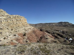
Hike to a viewpoint with a view of the curved cliff and surrounding terrain. Descend through a broad notch to a north-south plain then down a north-south arroyo.
CautionsHiking poles are advised since this hike is off trail over some rough terrain. Some of the terrain is sandy.
Trailhead Directions
From Albuquerque take I-25 south to the Lemitar exit. Go east for 0.5 mile on SR 408 E. Turn right onto SR-408 and go 3 miles to Escondido (Hidden) Lake. Turn left and go 1.6 miles (the road curves to the right after crossing the Rio Grande) to a sign “Quebradas Back Country Scenic Byway.” Turn left and go 16.2 mi. to PARK (0.0 mi). Park on the left in the bottom of the arroyo.
Actual Hike
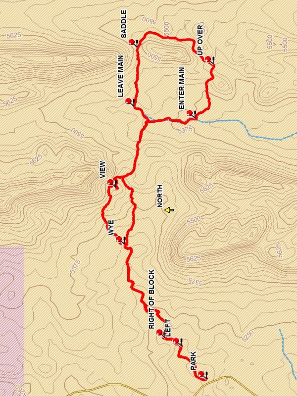
From parking start up the arroyo going to the east. At a split bear LEFT (0.3 mi). When you reach a blockage go RIGHT OF BLOCK (0.4 mi) climbing out then continue up the arroyo until the WYE (1.1 mi) is reached and bear left. Continue up and climb to the top of the hill to the right of the Curved Cliff and enjoy the VIEW (1.5 mi). Then descend down the east side of the hill to the side arroyo below and follow that arroyo down right to the main arroyo. Climb out of the main arroyo on the south side and go east over the rise ahead and take the small arroyo down to the main north/south arroyo. Go left to the LEAVE MAIN (2.1 mi) point and go directly east and over the SADDLE (2.5 mi) ahead and into a north /south arroyo. Go south down this arroyo to the UP OVER (3.0 mi) point and leave that arroyo and head west to ENTER MAIN (3.4 mi) where you head back north to the point where you first entered this arroyo. Retrace your steps except that when you reach the main east/west arroyo go down this arroyo rather than climbing up to the VIEW point.
Comments
The rating of the hike has been raised to C because the hike is off trail over rough terrain.
WaypointsPARK: N 33 59.024, W 106 45.689
LEFT: N 33 59.139, W 106 45.507
RIGHT OF BLOCK: N 33 59.215, W 106 45.460
WYE: N 33 59.399, W 106 44.946
VIEW: N 33 59.439, W 106 44.634
LEAVE MAIN: N 33 59.356, W 106 44.188
SADDLE: N 33 59.341, W 106 43.861
UP OVER: N 33 58.993, W 106 43.956
ENTER MAIN: N 33 59.077, W 106 44.253
Hike GPS File Name: QuebradasCurvedCliffWayTrack_DBDB.gpx
Hike GPS File: Click link to download hike waytrack file
Text Author: Dick Brown
Map Author: Dick Brown
Waypoints Author: Dick Brown
Track Author: Dick Brown
Maintainer: Not Assigned
Editor: Randy Simons