La Madera Road Hike
In Golden Region
Map File Source: DeLorme
 Hike Key: H10408
Last Updated: 12/15/2020 12:00am
Last Updated By: Marilyn Warrant
Hike Class: B (Moderate)
Hike Distance: 7.8 mi
Minimum Elevation: 5710 ft
Elevation Change: 240 ft
Total Uphill: 375 ft
Total Downhill: 375 ft
Avg. Grade: 2 %
Route Type: InOut
On Trail: Yes
Paved or Gravel Roads: No
GPS Advised: No
Drive Distance Round Trip: 70 mi
Drive Time One-Way: 1:00
Hiking Seasons: Spring, Summer, Fall, and Winter
New Mexico Game Unit: 8
Hike Status: Published
Highlights
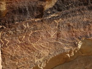
Nice scenery and vistas with unusual petroglyphs at the turnaround point. The hike follows a little-traveled dirt road for easy walking.
CautionsNone.
Trailhead Directions
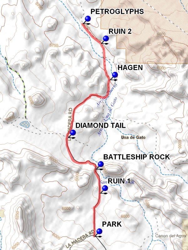
Take I-40 east to Tijeras exit #175. Travel north on NM 14 approximately 7 miles. Just past East Mountain High School turn left (west) on La Madera Road. Follow this road for 10.4 miles. There are several potentially confusing turns: at 5 miles turn right to continue on La Madera and at 6.4 miles turn left to continue on La Madera. At 7 miles the pavement ends. The dirt road will be difficult in wet weather. After descending steeply La Madera meets Puertocito Road. PARK (0.0 mi) at this junction on the Puertocito side. At the conclusion of the hike, follow Puertocito east for 6 miles to NM 14, then south to I-40.
Actual Hike
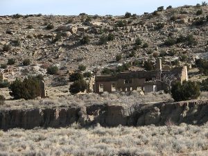
Cross the cattle guard and begin walking north on La Madera. Land on either side of the road belongs to Diamond Tail Ranch and trespassers are not welcome, but there’s much to see from the road. Ruins of Homestead appear first RUIN 1 (0.6 mi) on the right. Soon thereafter the cap rock on the right forms a cliff that locals call Suicide Rocks, while a more sculptural formation to the left is dubbed SHIPROCK (1.0 mi). An access road to the ranch crosses La Madera at DIAMOND TAIL (1.8 mi). The ruins of Hagan appear on the far side of an arroyo HAGAN (3.0 mi). This ghost town was settled first in 1902 to mine coal, but getting the product to market was a problem until a railroad spur reached the town in 1924. You can see ruins of the train depot, hotel, and adobe homes. By 1950 the boom turned to bust and Hagan was abandoned. High tension wires cross the road at this point; can you hear them humming? Ruins of a neighboring settlement can be seen from the road just after crossing the arroyo RUIN 2 (3.5 mi). Another cliff face appears on the right, this one with ancient petroglyphs where the cliff is closest to the road PETROGLYPHS (3.9 mi). Look for deer, spirals and very tall spirit figures. This is a good lunch spot.
Comments
The scenery and vistas along this hike route are quite nice. Though the hike follows a road, it is little traveled and quite easy walking. For more information on Hagan, see hike #20 in Stephen Ausherman’s 60 Hikes within 60 Miles Albuquerque and the website www.ghosttowns.com. Diamond Tail Ranch has a ritzy development near Placitas and a website at www.diamondtail.com.
WaypointsPARK: N 35 16.985, W 106 19.259
RUIN 1: N 35 17.520, W 106 19.174
SHIPROCK: N 35 17.819, W 106 19.237
DIAMOND TAIL: N 35 18.209, W 106 19.659
HAGAN: N 35 18.925, W 106 19.023
RUIN 2: N 35 19.375, W 106 19.160
PETROGLYPHS: N 35 19.620, W 106 19.434
Hike GPS File Name: LaMaderaRoadWayTrack_DBDB.gpx
Hike GPS File: Click link to download hike waytrack file
Text Author: Judie Schwartz
Map Author: Marilyn Warrant
Waypoints Author: Dick Brown
Track Author: Dick Brown
Maintainer: Not Assigned
Editor: Marilyn Warrant