Monte Negro Hike
In Socorro Region
Map File Source: NG Topo
 Hike Key: H10277
Last Updated: 03/04/2021 12:00am
Last Updated By: Marilyn Fixer
Hike Class: C (Challenging)
Hike Distance: 4 mi
Minimum Elevation: 5579 ft
Elevation Change: 895 ft
Total Uphill: 980 ft
Total Downhill: 980 ft
Avg. Grade: 10 %
Route Type: Lollypop
On Trail: No
Paved or Gravel Roads: No
GPS Advised: Yes
Drive Distance Round Trip: 140 mi
Drive Time One-Way: 2:00
Hiking Seasons: Spring, Fall, and Winter
New Mexico Game Unit: 13
Hike Status: Published
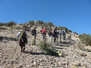
Highlights
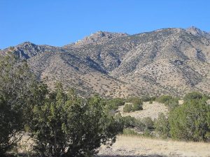
Colorful rocks, cactus, views.
CautionsA rocky route with some very steep sections; bring hiking poles.
Trailhead Directions
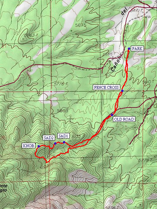
South on I-25 to exit 175 (Bernardo), about 40 yards into the exit left turn onto old US 85, at 0.4 miles right turn to dirt COUNTY B-12. At 10.4 miles of B-12 a left turn to RANCH ROAD. At 1.1 miles to gate (unlocked but close behind), then another mile (about) to the top of the hill, public lands fenced parking area on left. PARK (0.0 mi) here.
Actual Hike
From the parking area proceed due South for about 0.3 miles (the route is close to posted private land to the West). There are a few BLM route markers and cairns on this part of the hike. At the posted boundary of the Wilderness Study Area cross the fence FENCE CROSS (0.5 mi) and proceed generally South another 0.3 miles to the faint track of an OLDROAD (0.8 mi) going Southwest along the ridge. Follow the general route of the road SW until the significant ridge is reached. Then hike to the left of the higher ridge. Follow cattle/game trails above the arroyo to the SW, keeping above the larger rock in the arroyo until the low saddle SAD1 (1.4 mi) is visible to the right. There is a fair game trail up to this saddle. Going west on the ridge approach the next high point by angling to the right to avoid steep bedrock. Beyond saddle SAD2 (1.5 mi) go to the left under the rock outcrop and then up on the East side of the next rock outcrop to the ridge and the KNOB (1.7 mi), which has excellent vistas to the North and East. Return by the same route for a 3.4 mi hike, or for a slightly longer hike (additional 0.6 mi) continue by working around the head of the steep canyon to the south, turning easterly and gradually going down-slope to the mouth of the canyon where you join your incoming path and return to parking at PARK (4.0 mi).
Comments
This hike is off-trail over rocky and sometimes quite steep terrain. Hikers should be comfortable going up, down, and crossing precipitous slopes as steep as 27% grade. Good balance, good boots, protective gloves, hiking poles, hat and sunscreen will all be useful. The rewards here are great views to the north and east and interesting rock formations of granite, greenstone, quartzite, and dark slate.
WaypointsCOUNTY B-12: N34 24.270, W106 51.675
RANCH ROAD: N34 29.002, W107 00.170
PARK: N34 28.164, W107 01.865
FENCE CROSS: N34 27.767, W107 01.943
OLDROAD: N34 27.541, W107 02.059
SAD1: N34 27.286, W107 02.606
SAD2: N34 27.276, W107 02.705
KNOB: N34 27.248, W107 02.890
Hike GPS File Name: MonteNegroHike_bhks.gpx
Hike GPS File: Click link to download hike waytrack file
Text Author: Theodore (Ted) Cooley
Map Author: Ken Smith
Waypoints Author: Bill Hansen
Track Author: Ken Smith
Maintainer: Not Assigned
Editor: Marilyn Warrant